Micro-AUV Fleet to be Mobilized in SEAMAP Project

SEABER and CNRS-LEMAR et MARBEC are taking part in the France 2030 plan with the SEAMAP Project, and are set to deliver micro-AUV swarming technology for subsea expeditions By William Mackenzie / 15 Jul 2024

Autonomous Underwater Vehicles

Discover cutting-edge solutions from 9 leading global suppliers
SUPPLIER SPOTLIGHT
Follow OS&T

SEABER, working with CNRS-LEMAR et MARBEC, is set to take part in the France 2030 plan with the SEAMAP Project.

Micro-AUV Fleet to be Mobilized in SEAMAP Project

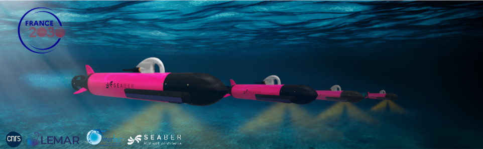
SEABER aims to move away from the costly and bulky technologies currently used in ocean mapping. Its flagship project entails the assembly of ten micro-autonomous underwater vehicles (AUVs) to form a fleet, each armed with a unique set of sensors. 

These sensors include environmental DNA (eDNA) samplers, passive acoustic monitoring systems, CTD (Conductivity, Temperature, and Depth) probes, magnetometers, and side-scan sonars. These will collectively enable the large-scale mapping and characterization of biodiversity on the ocean floor.

The micro-AUVs will form a swarm, collaboratively sharing knowledge and data. The vehicles will navigate with pinpoint accuracy to ensure that data collected is precisely mapped to its source, enhancing the reliability of findings.

The AUVs will also possess the endurance to traverse substantial distances, with up to 500km per mission, and will reportedly reduce mission costs by up to five times. 

The company is currently developing wider technologies for ocean exploration, such as:

  • 3D Spatialization of Measurements (Water Column Structure)
  • Fine-scale Mapping of Deep Benthic Habitats
  • Non-intrusive Sampling for Biodiversity
  • Passive Listening to Acoustic Landscapes (PAM)

SEABER will also develop CARTHA, an online service with a web interface, to bring together the data obtained by the micro-UAVs. This platform will serve as a hub for gathering and sharing geo-referenced oceanographic data obtained from the fleet of underwater micro-drones.

SEABER is setting out to develop novel tools and methodologies that enable the mass exploration of the seabed, in both marine biology and ecology. The project is funded by the French government through the France 2030 program.

The company aims to deploy thousands of high-performance, reliable, and cost-effective micro AUVs. SEABER will conduct future expeditions to remote and challenging locales, including Saint Pierre et Miquelon and Antarctica, to trial its technologies. 

Posted by William Mackenzie Edited by William Mackenzie, Junior Editor and Copywriter practised in digital content creation and writing about defense and marine technology. Connect & Contact

Latest Articles

Partnership to Advance Sustainable Practices in Subsea Operations

Ashtead Technology is partnering with Hydrollica to introduce a new generation of seawater-powered subsea tooling, promoting sustainability in subsea operations

Jul 18, 2025
Profile Spotlight: ALSEAMAR’s SEAEXPLORER Gliders for Oceanographic Monitoring

ALSEAMAR is presenting its SEAEXPLORER glider range on OST, offering autonomous underwater vehicles for long-duration environmental and industrial data acquisition

Jul 17, 2025
Profile Spotlight: SCIO Technology’s Modular Battery Systems for Maritime Vessels & Infrastructure

SCIO Technology is showcasing its SCIO Brick® battery system on OST, delivering modular electric power solutions for maritime vessels and infrastructure applications

Jul 16, 2025
Real-Time Video Streaming Now Available on SubC Imaging Systems

SubC Imaging has expanded streaming capabilities to Rayfin cameras, DVR+ Overlay and its Blackbox, through a straightforward, unified and consistent process across subsea configurations

Jul 16, 2025
SBG Systems Demonstrates Enhanced Performance of New Ellipse INS Firmware

SBG Systems evaluates its New Ellipse INS firmware through testing in AHRS and GNSS-aided modes, highlighting improved accuracy in dynamic, magnetic, and GNSS-denied conditions

Jul 15, 2025
Building Accurate 3D Seafloor Maps Using GIS & Geodetic Software

Researchers in Australia used Blue Marble Geographics’ Global Mapper® and Geographic Calculator® to convert raw bathymetric data into seamless 3D models for seabed mapping

Jul 15, 2025

Featured Content

Real-Time Video Streaming Now Available on SubC Imaging Systems

SubC Imaging has expanded streaming capabilities to Rayfin cameras, DVR+ Overlay and its Blackbox, through a straightforward, unified and consistent process across subsea configurations

Jul 16, 2025
Deep Trekker ROVs Streamline Offshore Inspections for Maritime Services Firm

Ynamly Yol Hyzmaty has adopted Deep Trekker’s ROV technology to enhance underwater inspection and non-destructive testing, reducing diver use and improving operational turnaround

Jul 14, 2025
New Unmanned Surface Vessel Outfitted with Voyager AI Survey System

Robosys Automation’s Voyager AI Survey has been integrated onboard Uncrewed Survey Solutions’ USS Accession, enhancing the vessel with advanced autonomous navigation and control capabilities

Jul 09, 2025