Discover World-Leading Technologies for Ocean Science
Discover cutting-edge solutions from leading global suppliers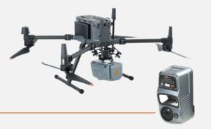 With the aim of improving waterway management, CHC Navigation is examining the use of its AlphaAir 10 LiDAR+RGB System on a DJI Drone to reveal waterway potential.
Digitizing inland waterways and utilizing technology could result in a wide range of benefits by leveraging data to enhance the sustainability, management, and safety of crucial navigation infrastructure.
Digitization streamlines the maintenance process by identifying possible challenges early, enabling the safety and reliability of waterways for transporting goods, passengers, and crucial resources.
On a Yangtze river waterway, CHCNav digitally maps the route, going on to discuss in a full case study:
- Precision Made Simple: 3D Mapping with UAV & LIDAR Technology
- Streamlined Excellence: Effortless Operation & Rapid Data Processing
- Transforming Waterway Surveying: The Power of LIDAR UAV Technology
- Elevating Surveying: LIDAR Innovation Soars Along the Yangtze River
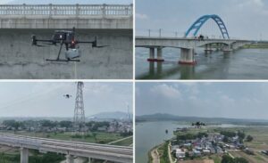
The ability to collect data at pace, paired with unparalleled precision, makes this technology an indispensable tool for surveying professionals along the Yangtze River.
The collaboration between AlphaAir 10’s LiDAR and UAV technology has brought forward a new era of accuracy and efficiency in waterway surveying.
Find out more about AlphaAir 10 (AA10) on CHCNAV’s website.