
Underwater Positioning
Discover cutting-edge solutions from 4 leading global suppliers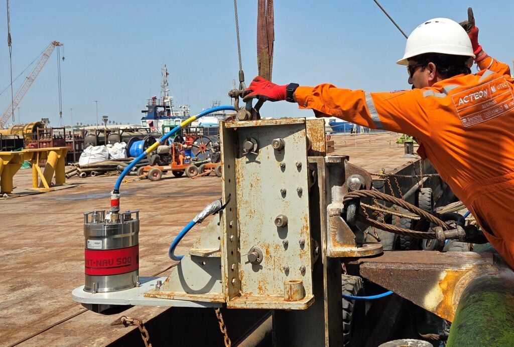
Sonardyne, a Kraken Robotics company, is working with UTEC, Acteon’s geo-services business, to support shallow-water pipelay operations in the Middle East using a hybrid acoustic-inertial positioning system designed to reduce reliance on GNSS.
The solution will be used across two projects involving more than 150 km of pipeline installation in water depths of less than 50 m. It will support the positioning requirements of pipelay barges and anchor-handling tugs, where accurate navigation is essential for managing construction activities amid potential GNSS interference, denial and spoofing.
Nadir Rahmatullah, Vice President Asia Pacific and Middle East at UTEC, commented, “The challenge is familiar to many offshore contractors working in regions where interference, denial and spoofing of GNSS signals – often the primary positioning reference for operators – are becoming operational realities. Pipelay barges must be moved precisely as pipe is installed, while support tugs need reliable position data as they run and manage anchors around the construction spread. Any loss of confidence in positioning can affect efficiency, safety and schedule.”
The positioning solution combines Sonardyne’s SPRINT-Nav navigation systems, Compatt 6+ Long Baseline (LBL) transponders and Fusion 2 LBL-INS survey software. SPRINT-Nav units mounted on the pipelay barges and support tugs will provide continuous navigation using inertial and doppler velocity log data.
When GNSS is available, operators can use satellite positioning alongside the inertial solution. Acoustic ranges to seabed-mounted Compatt 6+ transponders can be used to reference the navigation solution to fixed points on the seabed, providing an independent positioning layer that reduces reliance on GNSS when satellite signals become unreliable.
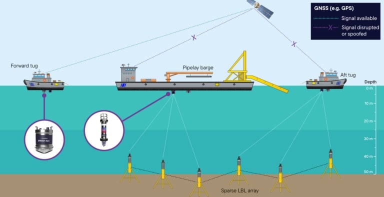
The configuration also enables Fusion 2 to use Simultaneous Localisation and Mapping (SLAM) to calibrate a sparse Compatt 6+ seabed array as the construction spread progresses along the pipeline route. This approach removes the need for dedicated conventional array calibration work, reduces the number of transponders required and helps speed up operations.
The combined architecture is designed to support routine positioning when GNSS is available, while providing an independent acoustic-inertial solution for higher-accuracy construction activities and greater resilience during periods of GNSS disruption.
Duncan Rigg, Business Development Manager, Ship Systems at Sonardyne, explained, “Using Fusion 2, Compatt 6+ and SPRINT-Nav in this way will show how acoustic and inertial technologies can be configured around the realities of a construction project, rather than forcing operations to fit a conventional survey model.
“By mounting SPRINT-Nav on the barges and tugs and using Fusion 2 to calibrate the sparse seabed array as the spread advances, UTEC will be able to maintain accurate positioning while keeping the seabed infrastructure lean.”
Mujmal Essa, Country Manager at UTEC, added, “For UTEC, this will provide a practical way to deliver resilient positioning for shallow-water pipelay while reducing array size and limiting the amount of time spent on dedicated calibration.”
The deployment is expected to demonstrate a more efficient, lower-complexity positioning approach for shallow-water pipelay operations in GNSS-challenged environments. The configuration could also provide an additional positioning solution for future offshore construction campaigns where resilience to GNSS disruption is increasingly important.