Autonomous Underwater Vehicles (AUV)
Discover cutting-edge solutions from 9 leading global suppliers
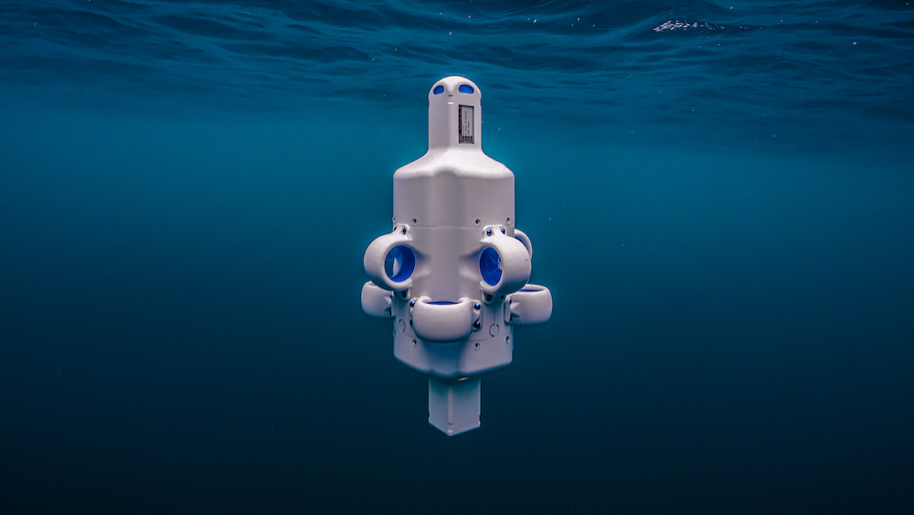
A team of ten undergraduate students at ETH Zurich has designed and field-tested an Autonomous Underwater Vehicle (AUV) capable of mapping ice thickness from beneath frozen Alpine lakes, reducing the need for people to walk across uncertain ice and drill numerous measurement holes.
Determining whether frozen surfaces can support a person or vehicle traditionally involves drilling through the ice and measuring it manually. Covering a large area can require hundreds of individual holes, placing personnel on the surface whose safety is being assessed. The POLARIS vehicle instead enters the water through a single access hole at a known-safe location and surveys the wider area from below.
Spatially resolved ice measurements also have potential research value. Consistent measurements of lake and sea ice remain comparatively scarce, limiting how accurately ice dynamics can be represented in climate models.
The team works with ETH Zurich’s Department of Earth and Planetary Sciences and the Swiss Seismological Service to help ensure that the collected data addresses relevant research questions.
For underwater localization and navigation, the 30-kilogram vehicle combines an inertial measurement unit, a Doppler Velocity Log, and a Short Baseline acoustic positioning system. This provides an estimated accuracy of approximately 2–7 meters, sufficient for the vehicle to return to its starting point but not for positioning individual measurements precisely on a scientific map.

Image credit: ETH Zurich
To improve positioning accuracy, the team mounted a Global Navigation Satellite System antenna inside an air-filled radome on top of the vehicle. The vehicle moves upward until the radome presses against the underside of the ice, separating the antenna from the water and leaving only the solid ice between it and the sky. When combined with real-time kinematic corrections from a shore-based station, the system achieved horizontal accuracy of up to 1.4 centimeters using commercially available receiver hardware.
The vehicle uses two methods to measure ice thickness. Its primary system combines a high-precision hydrostatic pressure sensor, which establishes the vehicle’s depth, with an upward-facing sonar that measures the distance to the underside of the ice. The difference between these measurements provides the ice thickness as the vehicle moves.
Because slush layers and multiple submerged ice interfaces can produce ambiguous acoustic returns, the team developed a second method based on hydrostatic pressure. The vehicle docks against the underside of the ice and measures the depth of the ice-water interface, known as the ice draft. Applying Archimedes’ principle and the known densities of ice and water enables the total thickness, including the freeboard above the waterline, to be calculated.
POLARIS was developed as an ETH Zurich Focus Project within the Department of Mechanical and Process Engineering. The team operates under the Academic Space Initiative Switzerland, with workshop and testing infrastructure at Switzerland Innovation Park Ost, mentorship from Tethys Robotics, and support from ETH Zurich’s Institute for Dynamic Systems and Control. The team comprises eight mechanical engineering students and two electrical engineering students who began the project with no previous experience building underwater robots.

Team POLARIS. Image credit: ETH Zurich
Noel Bühler, Team Lead and former Software Lead at POLARIS, said, “Nine months ago none of us knew what it means to build a submarine. We had lecture notes on calculus, physics and control theory, and that was about it. The gap between knowing an equation and getting a sealed pressure vessel to hold station and navigate under half a metre of ice, is where the actual learning happened.”
An NVIDIA Jetson AGX handles navigation, sensor fusion, and computer vision, while six thrusters provide six-degree-of-freedom control, allowing the vehicle to hold position against the ice during measurements. A slide-out electronics tray enables the internal systems to be serviced in field conditions, including inside a tent on a frozen lake.
During the 2025/26 winter season, the vehicle completed autonomous survey missions at Lake St. Moritz and Schwarzsee, near Zermatt. At Schwarzsee, located at an altitude of approximately 2,200 meters, it surveyed a 30-by-30-meter grid across 16 waypoints, with the results processed into color-coded maps showing variations in ice thickness.
The project was presented publicly at ETH Zurich’s Focus Rollout on May 27, 2026. The team sees the sensing and navigation techniques demonstrated on Alpine lakes as a possible foundation for repeated, non-invasive measurements in polar regions where conventional fieldwork can be difficult, expensive, or unsafe.