Synthetic Aperture Sonar for High-Resolution Underwater Imaging
Synthetic aperture sonar (SAS) delivers ultra-high-resolution imagery of the seafloor and submerged objects. Initially developed for military reconnaissance, SAS now supports a broad spectrum of underwater operations, from environmental monitoring to archaeological discovery. Synthetic aperture sonar achieves a level of detail and clarity far superior to traditional systems like side-scan or multibeam sonar by synthesizing data from multiple sonar pings and applying advanced beamforming techniques. This capability makes it a vital tool for commercial and research-based maritime initiatives.
If you design, build or supply Synthetic Aperture Sonar, create a profile to showcase your capabilities and connect with visitors who have an active requirement for your solutions.
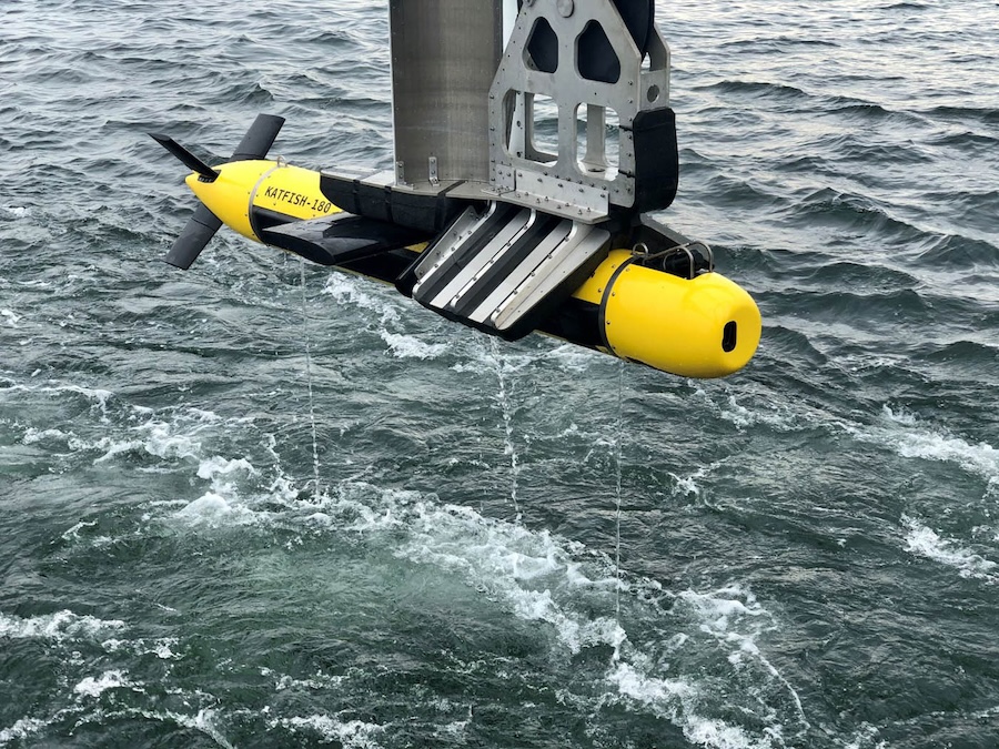
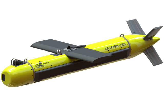
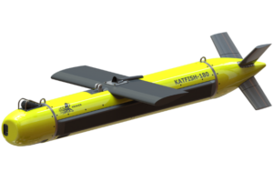
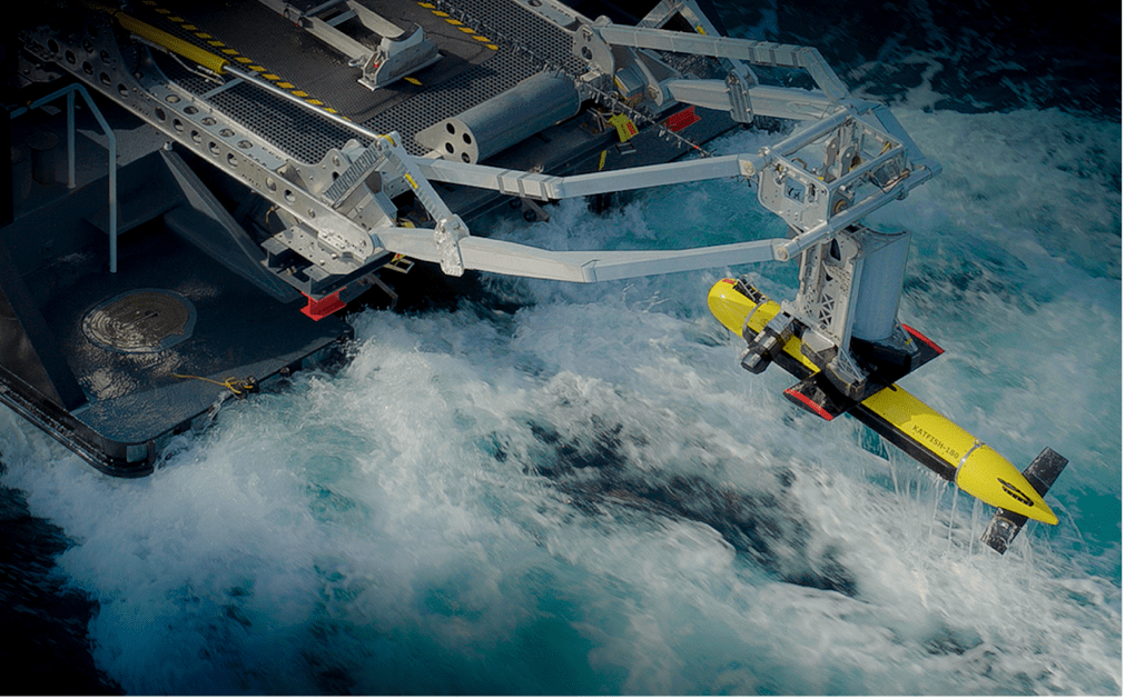
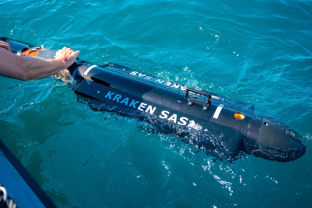
Complete towed SAS survey packages using the KATFISH towfish platform
Complete towed SAS survey packages using the KATFISH towfish platform
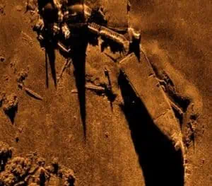
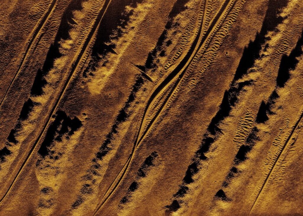
......a with unmatched seafloor resolution and wider swaths and faster speeds than towed sidescan... ...eted by Kraken sonar experts, ensuring accurate seabed classification and target discrimination as...
Overview of Synthetic Aperture Sonar for High-Resolution Subsea Imaging
Overview by
Sarah Simpson
Updated:
Synthetic aperture sonar (SAS) is an advanced sonar imaging technique that combines the data from successive pings as the sonar platform moves along a predefined path, effectively synthesizing a much larger sonar array than physically present. This synthetic array allows for significantly improved along-track resolution, independent of range, producing highly detailed two- and three-dimensional representations of underwater environments. The method draws conceptual parallels to synthetic aperture radar (SAR), but is optimized for acoustic propagation through water.
Unlike conventional systems such as side-scan sonar or multibeam sonar, which suffer from decreasing resolution with distance, SAS maintains a consistently high resolution across a wide swath. This is particularly advantageous for applications that require precision and clarity, such as mine detection, subsea infrastructure inspection, and seafloor mapping.
Introduction to Synthetic Aperture Sonar
Synthetic aperture sonar considerably outperforms traditional sonar systems in resolution and accuracy. By leveraging motion compensation, advanced signal processing, and coherent image synthesis, SAS delivers unprecedented clarity and detail over large survey areas. Its versatility and precision make it a valuable tool across various domains, including defense, oil and gas, archaeology, and scientific research.
As autonomous and remotely operated systems become more prevalent in subsea missions, the role of SAS is expanding. Its integration with navigation systems, acoustic modems, and real-time data processing tools enables smarter, more adaptive underwater operations. Whether mapping ancient shipwrecks or safeguarding critical infrastructure, synthetic aperture sonar continues to redefine what’s possible in marine exploration.
Applications of Synthetic Aperture Sonar
KATFISH towed Single Aperture Sonar (SAS), by Kraken Robotics Inc.
Military and Defense Operations
SAS was initially conceived for military reconnaissance and remains critical in defense scenarios. Its superior imaging capabilities allow for precise identification and classification of mines, unexploded ordnance, and submerged threats. The technology is often employed in multistatic sonar configurations to increase detection probability while minimizing detection by adversaries. Its compact deployment on AUVs and ROVs enhances stealth and operational flexibility in contested or hazardous waters.
Subsea Infrastructure Inspection
In commercial sectors, SAS is widely used for inspecting undersea assets such as pipelines, cables, and offshore platforms. Its high-resolution imagery enables detection of small anomalies or structural damage that traditional sonar might overlook. Cable route surveys, pipeline inspection, and platform base assessments all benefit from SAS’s ability to produce continuous, detailed mosaics of the seafloor.
Environmental Monitoring
Environmental scientists utilize SAS to monitor marine habitats, sediment transport, and ecological changes. SAS facilitates the mapping of benthic habitats and the identification of biotic and abiotic features, assisting with conservation and impact assessments. Its ability to function in low-visibility environments provides consistent data collection regardless of water clarity.
Underwater Archaeology and Cultural Heritage
SAS is pivotal in underwater archaeology, revealing shipwrecks, submerged settlements, and artifacts with minimal disturbance. Its non-invasive imaging approach preserves site integrity while providing archaeologists with detailed maps and 3D reconstructions. Coupled with inertial navigation and underwater GPS, SAS helps build precise site models that can be used for research or public exhibitions.
Scientific Seabed Mapping
Seafloor mapping and bathymetric surveys benefit significantly from the resolution and coverage SAS provides. SAS supports various marine geological and geophysical studies, from characterizing geological formations to conducting sediment analysis. The technology can generate high-fidelity topographic models essential for understanding tectonic activity, submarine landslides, and continental shelf morphology.
Object Detection and Classification
SAS is particularly suited for object classification tasks, offering high-contrast, high-resolution imagery that facilitates automatic and manual target recognition. It is used to locate lost cargo, sunken vessels, and even marine debris, often in combination with scanning sonar and interferometric techniques to determine object dimensions and reflectivity properties.
Autonomous Vehicle Navigation and Mission Planning
SAS enables real-time imaging and navigation updates when deployed on autonomous underwater vehicles. Coupled with INS and DVL systems, it allows AUVs to maintain accurate trajectories and adapt to terrain changes. Real-time SAS data can reroute vehicles, avoid obstacles, or refine search grids during missions.
Oil & Gas Exploration Support
In the oil and gas industry, SAS contributes to seafloor characterization during exploration and development phases. It helps determine suitable locations for drilling infrastructure and assess geological stability, reducing risks associated with subsea development.
Scientific Mosaicking and 3D Reconstructions
High-resolution SAS imagery is used to build large-scale mosaics of the seafloor and develop 3D reconstructions of complex underwater environments. These reconstructions assist in research, monitoring, and public outreach by visualizing underwater areas in fine detail. They are also valuable for change detection over time.
Multi-sensor Integration for Advanced Missions
Synthetic aperture sonar systems are increasingly integrated with multi-beam sonar, underwater imaging cameras, and various in situ sensors. These hybrid systems enhance data richness and enable comprehensive environmental characterization. Applications include ecosystem studies, resource assessment, and integrated oceanographic research.
Types of Synthetic Aperture Sonar
SAS systems vary in design depending on application and deployment method. Common modes include:
Stripmap mode: Provides consistent resolution across a linear swath, suitable for large-area surveys.
Spotlight mode: Focuses on a fixed region to achieve even higher resolution, ideal for target identification and inspection.
Interferometric SAS: Combines interferometry with SAS to extract bathymetric information and elevation models.
Multistatic SAS: Uses multiple distributed sonar sources and receivers to enhance coverage and reduce blind spots.
Each mode involves trade-offs in resolution, swath width, processing complexity, and system selection, depending on mission priorities.
How Synthetic Aperture Sonar Works
SAS systems transmit a sequence of sonar pings along a linear trajectory. As each ping returns, the system records echoes from the same patch of seafloor from multiple positions. Advanced signal processing algorithms, including spotlight beamforming and interferometric techniques, are then used to combine these signals coherently. This process effectively simulates a much larger aperture, dramatically enhancing image resolution.
Following a successful sea demonstration, Kraken Robotics and SEFINE SISAM have signed a memorandum of understanding to integrate advanced sonar and automated target recognition into unmanned surface vessel mission software
Kraken Robotics has secured orders totaling approximately $28 million for its SeaPower batteries and Synthetic Aperture Sonar technology from five global clients
Kraken Robotics demonstrated KATFISH sonar and autonomous launch and recovery system integration with SEFINE’s RD-22 unmanned surface vessel, enabling real-time detection and classification of mine-like objects off İstanbul in 2026
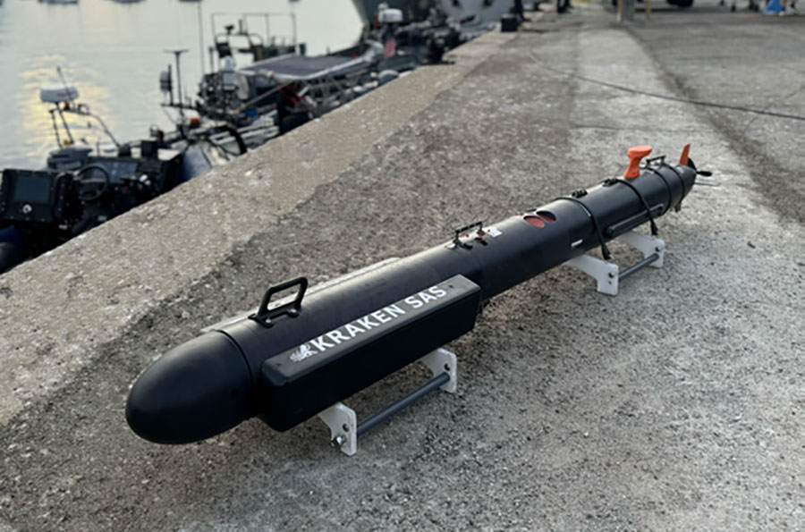
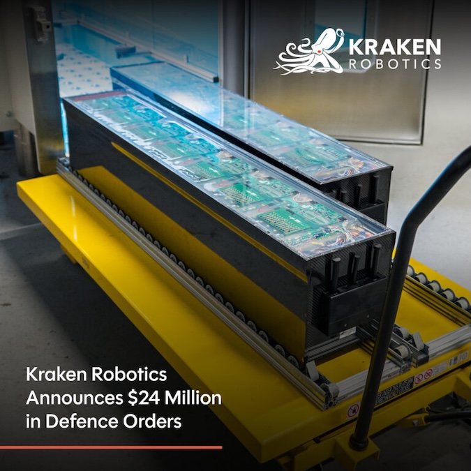
Kraken Robotics has received approximately $24 million in international defense orders from over 10 customers across five countries for SeaPower batteries, KATFISH towed synthetic aperture sonar, and Kraken SAS systems
Kraken Robotics and TKMS ATLAS UK demonstrate an autonomous USV launch and recovery system integrating towed synthetic aperture sonar for mine countermeasures and maritime security missions
Kraken Robotics has appointed BlueZone Group as an authorized reseller of its SAS and KATFISH platform, offering high-resolution underwater imaging, bathymetric mapping, and rapid data collection for defense and commercial surveys in Australia and New Zealand
A record number of international teams used Kraken Robotics’ synthetic aperture sonar during the 2025 REPMUS exercise, showcasing advanced interoperability in underwater operations
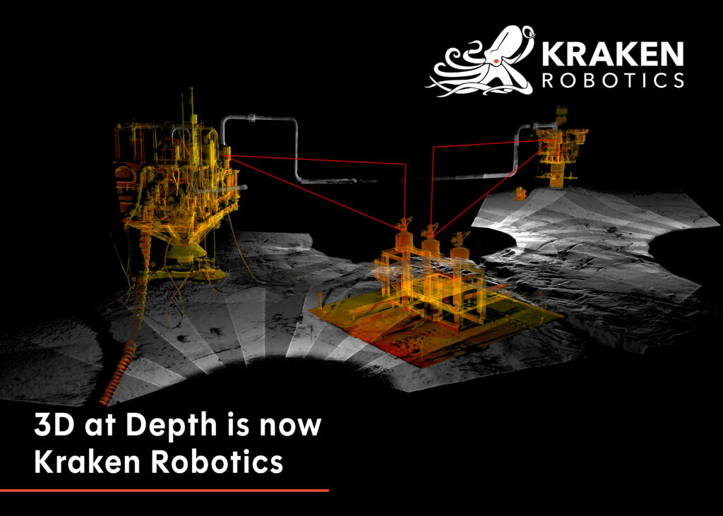
Following its acquisition of 3D at Depth, Kraken Robotics now offers an expanded portfolio of sonar, LiDAR, and subsea technologies, strengthening its position in ocean exploration and subsea solutions