Satellite Solution to Prevent Ship Groundings in Coastal Waters

TCarta Satellite Derived Bathymetry (SDB) utilizes Earth observation satellites to derive accurate water depth measurements in near-shore areas By Joe Macey / 10 Oct 2024

Connect with Leading Marine Technology Innovators

Discover cutting-edge solutions from leading global suppliers
SUPPLIER SPOTLIGHT
Follow OS&T

Multiple recent incidents in which naval and commercial vessels ran aground have highlighted the dangers of maritime operations in shallow or poorly charted coastal waters. TCarta Marine’s cost-effective, environmentally safe solution utilizes Earth observation satellites to derive accurate water depth measurements in near-shore areas.

TCarta Satellite Derived Bathymetry (SDB) on the Oman Coast indicates shallow water depths by color – red represents 0-3 meters, yellow is 3-6 meters, green is 6-10 meters, turquoise is 10-14 meters, and blue is 14-18 meters deep. Inset map indicates geographic location of data set. Credit: TCarta Marine.

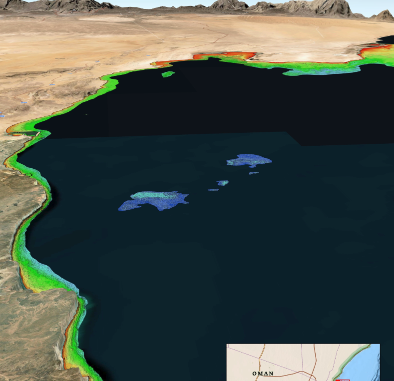
TCarta President Kyle Goodrich said; “While the exact causes of recent ship groundings off the coasts of Oman, Greenland, and Fiji are under investigation and often complex, the risk of such accidents can be significantly reduced with up-to-date bathymetric data produced from satellite imagery.

“Often in coastal areas, the regions outside commercial shipping lanes are poorly charted or not surveyed.”

Goodrich added; “Unfortunately, the collection of high-quality water depth measurements in shallow coastal areas – where they are needed the most – has traditionally been expensive and dangerous to acquire with ships or aircraft, especially in remote or contested regions.

“And the risk of groundings is only growing as military vessels and eco-tourism charters increasingly operate in unfamiliar and inadequately mapped coastal zones.”

For over 10 years, TCarta has been supplying marine charting organizations with water depth data using a technique called Satellite Derived Bathymetry (SDB). SDB applies physics-based computer algorithms to optical imagery captured by commercial remote sensing satellites. This analysis detects and measures light reflecting off the seafloor to calculate water depth. Depending on water clarity, SDB is routinely accurate to depths of 20 to 30 meters.

Goodrich said; “In addition to posing no danger to personnel, equipment, or coastal environments, satellites are more cost effective than ship-borne sonar or airborne laser scanning because they acquire image data over large regions in seconds.

“And because satellites orbit without geographic restrictions, data can be collected for areas otherwise off limits to vessels or aircraft.”

TCarta has mapped nearly one third of the world’s coastlines with SDB and offers products in custom and off-the-shelf versions. Custom SDB data sets are typically generated using high-resolution satellite imagery capable of resolving seafloor objects, such as shoals and reefs, with one-meter resolution.

The off-the-shelf bathymetry product Global Satellite Derived Bathymetry (G-SDB) offers 10-meter detail and is ideal for identifying coastal shoals in remote areas that don’t appear on nautical charts. Large-area contiguous G-SDB products are immediately available for more than a dozen critical locations, including:

  • South China Sea
  • Arabian/Persian Gulf
  • Gulf of Oman
  • Red Sea
  • Black Sea
  • Eastern Mediterranean
Posted by Joe Macey Connect & Contact

Latest Articles

Advanced Navigation Integration Enhances Side Scan Sonar Precision

Klein Marine Systems has selected Exail’s navigation technology to enhance the precision and reliability of its 5900 Side Scan Sonar system

May 02, 2025
Uncrewed Surface Vessel Employs Acoustic Tech for Real-Time Marine Mammal Monitoring

A collaboration between JASCO and SeaTrac is set to enhance real-time marine mammal monitoring using autonomous, energy-efficient surface vehicles

May 02, 2025
Profile Spotlight: Cambridge Pixel’s Radar & Sensor Data Solutions for Maritime & Offshore Operations

Cambridge Pixel is showcasing its advanced radar, sensor, and tracking technologies on OST, providing mission-critical solutions for maritime and offshore operations, including surveillance, asset protection, and USV sensor processing

May 02, 2025
Advanced Multibeam Sonar Technology Expands Capabilities in Offshore & Energy Sectors

Oceanscan Singapore expands its global rental fleet with the latest NORBIT multibeam sonar systems, enhancing survey capabilities for energy and offshore markets

May 01, 2025
AGISTAR Unveils Compact Remote-Controlled Motor for Inflatable Boats

AGISTAR has unveiled the OXR-T100, a compact, remote-controlled electric motor engineered for inflatable boats, delivering quiet, eco-friendly performance across demanding marine environments

May 01, 2025
AXYS Technologies MetOcean Observation Networks

AXYS Technologies supplies high-precision MetOcean data solutions that support marine safety, scientific research, environmental monitoring, and policy development across more than 80 countries

Apr 30, 2025

Featured Content

Advanced Multibeam Sonar Technology Expands Capabilities in Offshore & Energy Sectors

Oceanscan Singapore expands its global rental fleet with the latest NORBIT multibeam sonar systems, enhancing survey capabilities for energy and offshore markets

May 01, 2025
D-2 Ultra Low Power CTD Integrated into WHOI Arctic Research

D-2 Inc.’s advanced CTD sensor supports WHOI’s Arctic climate research, enhancing data precision in the Ice Tethered Profiler program’s latest deployments

Apr 30, 2025
Case Study: Impact Subsea Altimeter Supports Antarctic Science

Impact Subsea's ISA500 underwater altimeter plays a key role in the Icefin AUV as it collects vital data, passing through narrow boreholes drilled into Antarctic ice shelves

Apr 23, 2025