


Discover World-Leading Technologies for Ocean Science
Discover cutting-edge solutions from leading global suppliers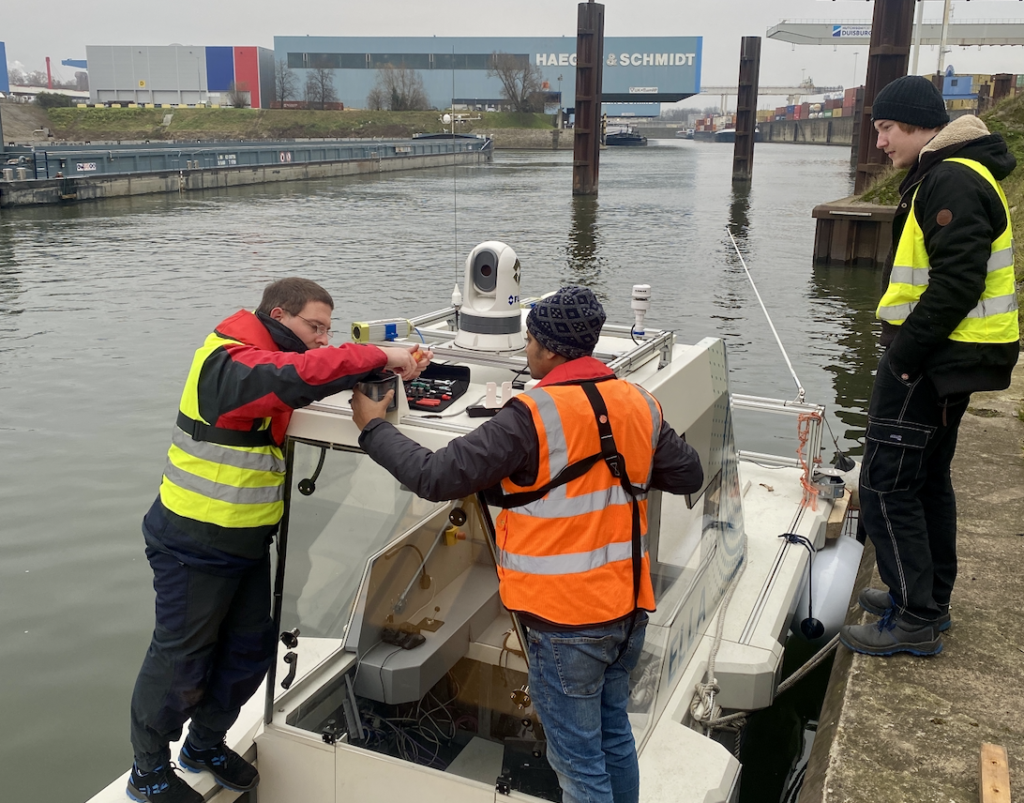
DST, a development centre for marine technology and transport systems that heads up the project FernBin for remotely controlled, coordinated inland navigation, will travel to XPONENTIAL Europe in Düsseldorf from 18-20 February, 2025, with “heavy luggage” ELLA measuring 15 LOA, which is currently being tested in autonomous navigation.
Standing at the bridge Stephan Schweig looks as if he was aboard a starship. A cone-shaped 360° projection system with a diameter of 8 metres is suspended from the ceiling of the “VeLABi” (Test and Performance Centre Autonomous Inland Navigation Vessels). 19 overhead projectors show the way to the research assistant at the DST.
Today’s navigation is on home turf, the Vincke canal, which connects the Rhine with the Duisburg Ruhrort free port area. This is a test track owned by the duisport Group operating Europe’s biggest inland port. DST regularly uses the Vincke canal for test trials.
By now, Stephan Schweig knows the 105m “Ernst Kramer” he is manoeuvring virtually inside out. The real cargo ship, built in Bodenwerder in 1974, was made available and correspondingly “tuned” by shipping company Rhenus PartnerShip as a research vessel for the FernBin project. Schweig refers to this as a retrofit –which is important because it shows that even existing inland navigation vessels – most of them between 30 and 50 years old – are suitable for remote control. The “Ernst Kramer” was retrofitted accordingly: analogue processes were replaced to allow the pilot to remotely access the main engine, rudder, bow thruster as well as radio and radar systems.
Today, the vessel features a variety of cameras, LiDAR sensors, high-precision GNSS-antennas and the respective mobile communications technology for a fast, safe and redundant transmission of large data volumes. All this serves to transmit the on-board navigation and control data. This includes not only the operating data of the engines and rudder systems but also that of the two radar systems and the electronic nautical chart display including the data generated by the navigation communication system AIS. This data is processed and displayed in real time on the remote helm stand.
To ensure safe, remotely controlled navigation, and proven driver assistance systems are used, proprietary assistance systems developed, and existing ones are enhanced. One of them being the ArgoTrackPilot by Argonics GmbH. This company from Stuttgart-Vaihingen is a market leader “made in Germany” in the field of automated track piloting. With the ArgoTrackPilot, which is now already embedded in a number of inland vessels, these vessels remain on track following a pre-set route.
Remotely Controlled Inland Navigation as a Technology of the Future
Dr. Frédéric Kracht, who is the Department Chief for Autonomous Driving at DST, already expects a quantum leap in the next few years, bringing plenty of dynamism, stated, “The development of automation systems in inland navigation is so advanced today that the skipper is supported by a track-piloting system when cruising on rivers or canals and, hence, performs a purely supervisory task at least part of the time and only has to intervene in more complex situations. The remote control of inland navigation vessels is therefore considered a key future technology in this industry to counter skilled labour shortages.”
German inland navigation, experts estimate, is already short of around 1,500 skippers today. A good third of skippers are over the age of 55. A total of 8% of cargo services are rendered by inland vessels. Another reason why FernBin was funded by the Federal Ministry of Economic Affairs and Climate Action with a total of EUR 6 million. Altogether, eight partners are involved on the project led by DST, including the
University Duisburg-Essen with its chairs for Marine Engineering, Mechatronics and Dynamics and Control, the Institute of Automatic Control at RWTH Aachen, the German Federal Waterways Engineering and Research Institute as well as the companies Argonics, Ingenieurbüro Kauppert, IN – Innovative Navigation, Argonav and shipping company Rhenus as an associated partner making the inland vessel “Ernst Kramer” available.
The quantum leap, however, that Kracht refers to, requires regulatory changes. Unlike in Belgium where three uncrewed cargo ships already operate in the hinterland of Oostende, and further vessels are run with reduced crews between Liège and Antwerp, German authorities are still struggling with approvals. At present, the application period is open for further stretches of the canal system in north-west Germany, of the Mittelland Canal and for further sections of the Rhine.
ELLA – Autonomously Cruising Research Vessel
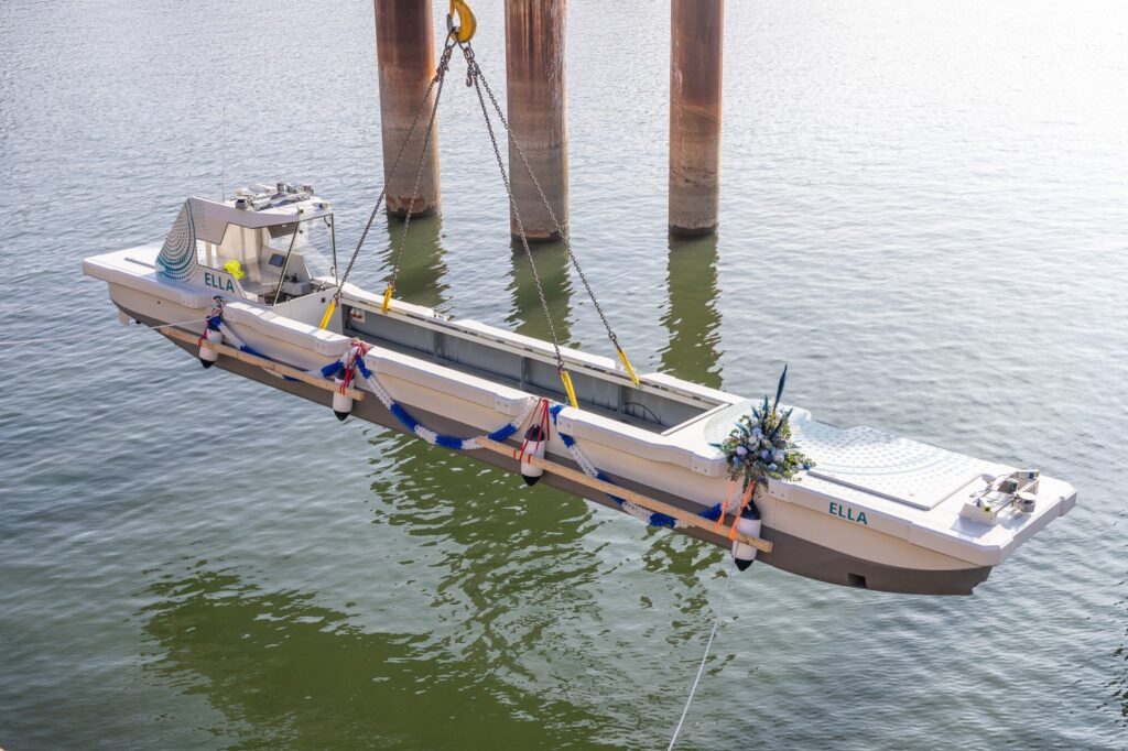
ELLA illustrates what the future might look like: the DST research vessel is considered a pioneering project for fully automatic manoeuvring on inland waterways. In the final development stage, the aim for the vessel’s pilot system is to be capable of reaching a pre-set destination independently and safely. This innovative watercraft was developed and built by DST as part of a research project co-funded by the Federal Ministry for Digital and Transport. A 1:6 scale model, the electrically propelled cargo ship is a rebuild of a freight ship – 15 metres long, 1.6 metres wide and weighing 6.5 tons. ELLA is equipped with bow and stern thrusters, six ultrasonic sensors, two 3D cameras, GNSS satellite transmission plus 4 and 5G connectors as well as an AIS link and a “lane-keeping” assistance system.
Since its christening on 3rd March, 2023, ELLA has been fed with data. Step-by-step ELLA learns to plan and execute the required manoeuvres with the help of AI, human piloting behaviour and her own test trials.
Centrestage is a special challenge for autonomous vessels: the execution of complex manoeuvres in tight spaces such as port and sluice/lock-related manoeuvres.
Unlike cruising on canals or rivers these cannot be described in linear planning specifications.
Starting in December, the trial phase for initial mooring and casting-off manoeuvres on the Vincke canal has produced promising results, although Frédéric Kracht and his team know there is still a long way to go to regular operations. But he has no doubts, saying, “At the end of the planned developments in the ELLA project we will have made a step forward on our way to completely autonomous inland navigation.”
He is delighted that ELLA will make her way to Düsseldorf, adding, “Sharing notes with colleagues who deal with autonomous systems – be it on water, track, road or in the air – is of great importance to us.”
Autonomous Technologies at XPONENTIAL Europe
This is precisely the aim of XPONENTIAL Europe, says Malte Seifert, Director Metals & Autonomous Technologies at Messe Düsseldorf, “Technology and linking the projects of various transport modes – is what this is all about. ELLA is a beacon project at the heart of a region that is developing into a research and development centre for uncrewed systems. This also shows that Düsseldorf is the right location for a trade fair with international aspirations.”
Register for XPONENTIAL Europe in Düsseldorf >>
Thanks to Dr. Mike Seidensticker, expert author.


