MantaRay™ OBN Handling System Developed

PXGEO and Saab have collaborated to unlock the full potential of Ocean Bottom Node (OBN) seismic technology with the introduction the MantaRay OBN handling system By Sarah Simpson / 10 Jul 2023

Discover World-Leading Technologies for Ocean Science

Discover cutting-edge solutions from leading global suppliers
SUPPLIER SPOTLIGHT
Potential of Ocean Bottom Node Seismic Technology Unlocked
Follow OS&T

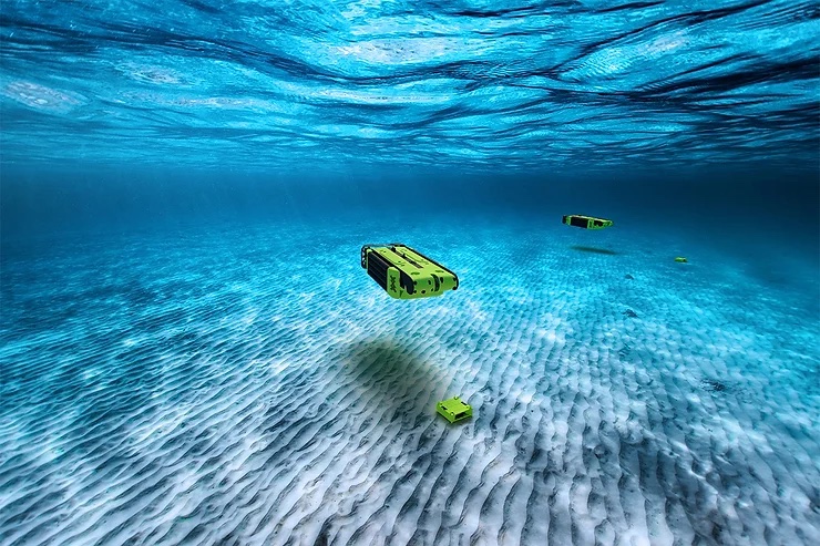
Developed by marine geophysical service provider PXGEO, in collaboration with Saab, MantaRay™ is a next-generation Ocean Bottom Node (OBN) handling system that uses Hovering Autonomous Underwater Vehicles (HAUV) capable of deploying and recovering nodes significantly faster and with better precision than traditional methods.

MantaRay is based on Saab’s proven Sabertooth platform, a powerful and versatile unmanned underwater vehicle (UUV), ideal for seabed investigations and capable of operating in water depths ranging from 4m – 3,000m.

Effective, efficient, and reliable, MantaRay is unlocking the full potential of OBN seismic data by enabling complete survey design flexibility and providing optimal imaging to eliminate geological risk. MantaRay also minimizes seabed impact and reduces crew and operational exposure while bringing results faster to the client.

Autonomous, tether-less operation delivers unparalleled efficiency, whilst pre-programmed autonomous mission planning ensures fast and accurate node placement.

Tony Bowman, CEO of PXGEO, commented; “We are very excited to present MantaRay with its unmatched effectiveness, efficiency, and reliability, it will revolutionize the OBN industry and aligns with PXGEO’s commitment to United Nations Sustainable Development Goals. I’m proud of our Engineering team’s relentless work and collaboration with Saab in developing MantaRay. We expect to have the initial fleet of MantaRays in full operation by the end of the year.“

Görgen Johansson, head of Saab’s business area Dynamics, stated: “Together with PXGEO, we are taking the step to make offshore seismic data acquisition fully autonomous. This breakthrough order is a great achievement and a significant milestone, made possible by our combined expertise.”

Posted by Sarah Simpson Sarah is Head of Content at Ocean Science Technology and has become a respected voice in marine technology and autonomous marine systems. With a career rooted in research and journalism, Sarah joined in 2023 and specializes in translating the complex world of ocean robotics, subsea exploration, and autonomous vessels into compelling, accessible content. Connect

Latest Articles

Profile Spotlight: IQUA Robotics for Autonomous Underwater Survey & Inspection

IQUA Robotics is presenting its hovering AUV technologies on OST, providing precise, maneuverable platforms for subsea mapping, inspection, and reconnaissance

Nov 20, 2025
Precision Terrain Modeling & Hydrological Analysis with Global Mapper

Blue Marble Geographics’ Global Mapper enables Egis to streamline digital terrain modeling and hydrological analysis, enhancing data processing efficiency across large-scale environmental projects

Nov 20, 2025
Real-Time Vibration Analysis Embedded in SBG Systems IMU

SBG Systems’ IMU now features built-in vibration monitoring, delivering real-time analysis to enhance accuracy, detect resonance, and support design, testing, and structural monitoring

Nov 19, 2025
Kraken Robotics Forms Reseller Partnership to Expand Access to Subsea Sonar Technology

Kraken Robotics has appointed BlueZone Group as an authorized reseller of its SAS and KATFISH platform, offering high-resolution underwater imaging, bathymetric mapping, and rapid data collection for defense and commercial surveys in Australia and New Zealand

Nov 19, 2025
Monitoring Marine Environments with Pro-Oceanus Dissolved Gas Sensors

Discover how Pro-Oceanus Systems’ advanced sensors help explore the oceans, measure dissolved gases, and uncover critical insights into marine and climate processes

Nov 18, 2025
Strategic Partnership to Deliver High-Resolution Deep-Sea Seafloor Intelligence & Insights

PlanBlue and Orpheus Ocean have collaborated to integrate advanced AI-driven imaging with autonomous underwater vehicles, enabling enhanced monitoring and analysis of critical deep-sea environments

Nov 17, 2025

Featured Content

FarSounder Integration Delivers Real-Time Seafloor & Obstacle Detection to SYNAPSIS Users

FarSounder has integrated its Argos 3D Forward Looking Sonar with Anschütz’s SYNAPSIS navigation platform, bringing real-time subsurface insights directly into the (W)ECDIS NX interface

Nov 17, 2025
Boxfish ROV Captures Marine Research Footage for Upcoming Premiere

Scientists from the University of Tasmania used a custom Boxfish ROV to survey Beagle Marine Park, capturing underwater footage premiering on YouTube this November

Nov 12, 2025
SubC Imaging Observatory Camera Systems Support Long-Term Ocean Observation

SubC Imaging’s Observatory Camera Systems capture detailed subsea imagery for cabled ocean observatories, enabling continuous observation and long-term marine environmental studies

Nov 11, 2025