Connect with Leading Marine Technology Innovators
Discover cutting-edge solutions from leading global suppliers
NOAA’s National Coral Reef Monitoring Program (NCRMP) launched a new data visualization tool today, which will provide free and easy-to-access information on the status of U.S. coral reefs.
It is the first tool focusing on shallow tropical coral reef data to be hosted on the NOAA GeoPlatform, which is NOAA’s central hub for geospatial data and tools.
Now stakeholders, scientists, managers and students have a one-stop information hub to access and understand NOAA’s shallow tropical coral data that they can customize to focus on coral trends across specific timescales, locations, coral or fish species, climate data and socioeconomics.
NCRMP is one of the few initiatives in the world to integrate a human dimensions component of research into a coral reef ecosystem monitoring program. This data visualization tool is the first NOAA coral product to feature social parameters as part of a comprehensive analysis of coral status.
It can be used to see how residents interact with coral reefs and examine their perceptions of coral reef conditions over time, which are key data points for managers who develop locally-appropriate conservation and management strategies.
Accessing data is a key component of this new visualization tool. For the first time, users can download streamlined data summaries for each available year at different geographic scales.
Users asked for and received ways to filter and download data in an easy-to-understand format, allowing researchers and decision-makers to develop custom datasets with actionable, situation-specific information.
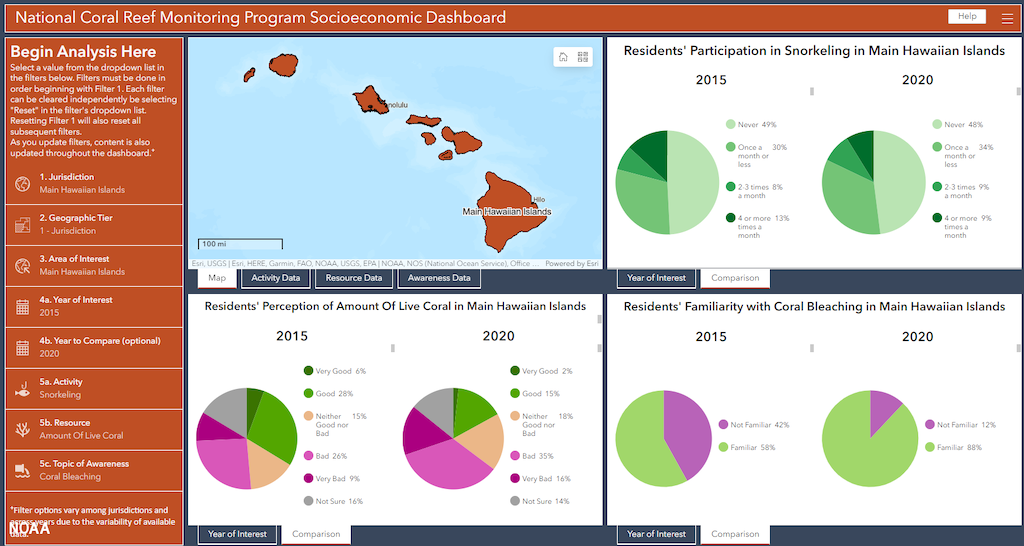
The tool covers data collected since 2013 across four themes: benthic communities (corals, macroalgae and more); fish populations; climate and ocean chemistry; and socioeconomics. It encompasses the diverse range of coral reefs within the nation’s states and territories of Florida, the U.S. Virgin Islands, Puerto Rico, and more. It also includes data from various other organizations and sanctuaries.
The NCRMP’s new data visualization tool is a portal into NOAA’s vast portfolio of information on coral reef status and trends, and a powerful tool for ongoing efforts to conserve these remarkable and fragile ecosystems.
“NOAA’s coral monitoring activities represent a truly comprehensive array of data and information — from biological and physical characteristics of reefs to insights into how surrounding communities perceive and protect their reef resources,” said Nicole LeBoeuf, assistant administrator, NOAA’s National Ocean Service.
Jennifer Koss, director of NOAA’s Coral Reef Conservation Program, said; “To have this data available in an accessible, visual format will enable scientists and managers to make on-the-ground assessment and conservation decisions more easily. This is also a chance for researchers, students and engaged conservationists to gain an understanding of U.S. coral reef ecosystems and how people value them.”