New AI Software for Smart Ship Conversion

Seadronix’s AI software Rec-SEA draws on its onboard LiDAR and RADAR sensors to modify standard ships into smart ships, providing enhanced safety and efficiency across maritime operations By William Mackenzie / 16 Apr 2024

Discover World-Leading Technologies for Ocean Science

Discover cutting-edge solutions from leading global suppliers
SUPPLIER SPOTLIGHT
Follow OS&T

AI maritime solutions manufacturer Seadronix has launched the Rec-SEA Plugin, a cutting-edge AI software that converts regular ships into smart ships.

New AI Software for Smart Ship Conversion

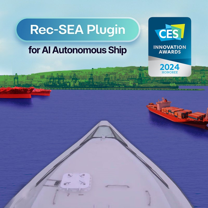
Utilizing existing onboard sensors, such as LiDAR and RADAR, the Rec-SEA Plugin offers enhanced safety and efficiency across maritime operations. 

The plugin features five modules designed to augment navigation and safety. These modules provide key functions such as generating precise 3D maritime maps, optimizing navigation paths, detecting maritime objects and personnel, and enabling real-time tracking of multiple objects around the ship. Seadronix say that each module represents a step towards integrating AI and robotics within the maritime domain, showcasing the company’s innovative technologies.

The Rec-SEA Plugin is now available, with the first international installations anticipated in the latter half of 2024. Seadronix assert that by integrating AI into everyday maritime operations, the company is not just innovating for the present but is steering the future course of the entire industry towards a smarter and safer maritime future.

This innovation was recognized with a CES 2024 Innovation Award in the Unmanned and Drones category. The Rec-SEA Plugin was showcased at the Sea Japan Exhibition and Singapore Maritime Week 2024, where Seadronix’s COO, Kyongsoo Noh, delivered a keynote speech.

Seadronix COO Kyongsoo Noh discussed the company’s participation in Singapore Maritime Week, commenting; “Presenting our latest technology at such a prestigious event is a proud moment for us. Our commitment to developing leading AI-enabled solutions is unwavering, and we aim to propel the maritime industry into a new era of innovation and safety.”

Byelteo Park, Seadronix CEO, added; “The introduction of the Rec-SEA Plugin is a monumental step towards autonomous maritime navigation. It embodies our vision of equipping navigators with cutting-edge tools to maximize vessel potential, assist navigators to reduce errors, and thereby enhance safety and operational efficiency.”

Posted by William Mackenzie Will is a Content Specialist at Ocean Science Technology. Joining in 2024 with a background in professional copywriting and creative content, Will brings expertise in oceanographic monitoring, aquaculture, and environmental analysis. He provides in-depth coverage of breakthroughs in marine research, subsea systems, and autonomous platforms, drawing on his specialist understanding of ocean technology to highlight innovations shaping the future of the marine industry. Connect

Latest Articles

Profile Spotlight: IQUA Robotics for Autonomous Underwater Survey & Inspection

IQUA Robotics is presenting its hovering AUV technologies on OST, providing precise, maneuverable platforms for subsea mapping, inspection, and reconnaissance

Nov 20, 2025
Precision Terrain Modeling & Hydrological Analysis with Global Mapper

Blue Marble Geographics’ Global Mapper enables Egis to streamline digital terrain modeling and hydrological analysis, enhancing data processing efficiency across large-scale environmental projects

Nov 20, 2025
Real-Time Vibration Analysis Embedded in SBG Systems IMU

SBG Systems’ IMU now features built-in vibration monitoring, delivering real-time analysis to enhance accuracy, detect resonance, and support design, testing, and structural monitoring

Nov 19, 2025
Kraken Robotics Forms Reseller Partnership to Expand Access to Subsea Sonar Technology

Kraken Robotics has appointed BlueZone Group as an authorized reseller of its SAS and KATFISH platform, offering high-resolution underwater imaging, bathymetric mapping, and rapid data collection for defense and commercial surveys in Australia and New Zealand

Nov 19, 2025
Monitoring Marine Environments with Pro-Oceanus Dissolved Gas Sensors

Discover how Pro-Oceanus Systems’ advanced sensors help explore the oceans, measure dissolved gases, and uncover critical insights into marine and climate processes

Nov 18, 2025
Strategic Partnership to Deliver High-Resolution Deep-Sea Seafloor Intelligence & Insights

PlanBlue and Orpheus Ocean have collaborated to integrate advanced AI-driven imaging with autonomous underwater vehicles, enabling enhanced monitoring and analysis of critical deep-sea environments

Nov 17, 2025

Featured Content

FarSounder Integration Delivers Real-Time Seafloor & Obstacle Detection to SYNAPSIS Users

FarSounder has integrated its Argos 3D Forward Looking Sonar with Anschütz’s SYNAPSIS navigation platform, bringing real-time subsurface insights directly into the (W)ECDIS NX interface

Nov 17, 2025
Boxfish ROV Captures Marine Research Footage for Upcoming Premiere

Scientists from the University of Tasmania used a custom Boxfish ROV to survey Beagle Marine Park, capturing underwater footage premiering on YouTube this November

Nov 12, 2025
SubC Imaging Observatory Camera Systems Support Long-Term Ocean Observation

SubC Imaging’s Observatory Camera Systems capture detailed subsea imagery for cabled ocean observatories, enabling continuous observation and long-term marine environmental studies

Nov 11, 2025