Full INS Integrated on Small Subsea Vessels

Nortek’s Nucleus software can show a vehicle’s location in real time on a map using inputs from its sensors and the company’s navigation algorithms By Abi Wylie / 06 Oct 2023

Inertial Navigation Systems (INS)

Discover cutting-edge solutions from 5 leading global suppliers
SUPPLIER SPOTLIGHT
Full INS Integrated on Small Subsea Vessels
Follow OS&T

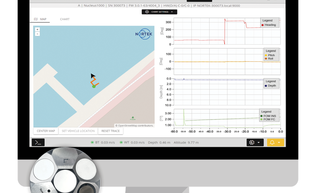
Nortek’s Nucleus1000 navigation sensor suite is now available with full inertial navigation system (INS) capabilities, enabling absolute position outputs to be obtained. 

These outputs are gained using the Nucleus’s on-board inertial and acoustic sensor package.

With these new capabilities, the company asserts people working in the subsea industry now have access to the most compact, most affordable and most accurate complete inertial/acoustic navigation system of its class available on the market.

With a heading sensor that measures relative to magnetic north, as well as integrated temperature and pressure sensors, the Nucleus with INS introduces the most compact, most affordable and most accurate complete inertial/acoustic navigation system of its class yet.

This comes with a series of new updates to the Nucleus package, including:

  • New drivers, easing the software development and integration process, including BlueOS, Python, ROS2 and third-party survey software packages
  • 1000m depth rated version
  • “No license required” option (currently only available for DVL + AHRS version)

In addition to a dedicated INS data stream, the Nucleus software can show a vehicle’s location in real time on a map using inputs from its sensors and Nortek’s navigation algorithms.

The Nucleus1000 is a preconfigured, pre-synchronized navigation package, with users now able to add a convenient source of basic positioning to their vehicle without substantial time, cost and payload demands. 

The Nucleus only needs to be provided with a GPS position to begin navigating using absolute positioning.

Providing earth-referenced position to a vehicle control system means that users who need to know where they are, where they’ve been and where they’re going now have a preconfigured, pre-synchronized navigation package.

Prior to this, users would have to fuse data from multiple different sensors to obtain a reliable position output, either through their own software or additional third-party packages.

Posted by Abi Wylie Edited by Abigail Wylie, Editor and Copywriter experienced in digital media with a keen interest in ocean science technology. Connect

Latest Articles

Profile Spotlight: IQUA Robotics for Autonomous Underwater Survey & Inspection

IQUA Robotics is presenting its hovering AUV technologies on OST, providing precise, maneuverable platforms for subsea mapping, inspection, and reconnaissance

Nov 20, 2025
Precision Terrain Modeling & Hydrological Analysis with Global Mapper

Blue Marble Geographics’ Global Mapper enables Egis to streamline digital terrain modeling and hydrological analysis, enhancing data processing efficiency across large-scale environmental projects

Nov 20, 2025
Real-Time Vibration Analysis Embedded in SBG Systems IMU

SBG Systems’ IMU now features built-in vibration monitoring, delivering real-time analysis to enhance accuracy, detect resonance, and support design, testing, and structural monitoring

Nov 19, 2025
Kraken Robotics Forms Reseller Partnership to Expand Access to Subsea Sonar Technology

Kraken Robotics has appointed BlueZone Group as an authorized reseller of its SAS and KATFISH platform, offering high-resolution underwater imaging, bathymetric mapping, and rapid data collection for defense and commercial surveys in Australia and New Zealand

Nov 19, 2025
Monitoring Marine Environments with Pro-Oceanus Dissolved Gas Sensors

Discover how Pro-Oceanus Systems’ advanced sensors help explore the oceans, measure dissolved gases, and uncover critical insights into marine and climate processes

Nov 18, 2025
Strategic Partnership to Deliver High-Resolution Deep-Sea Seafloor Intelligence & Insights

PlanBlue and Orpheus Ocean have collaborated to integrate advanced AI-driven imaging with autonomous underwater vehicles, enabling enhanced monitoring and analysis of critical deep-sea environments

Nov 17, 2025

Featured Content

FarSounder Integration Delivers Real-Time Seafloor & Obstacle Detection to SYNAPSIS Users

FarSounder has integrated its Argos 3D Forward Looking Sonar with Anschütz’s SYNAPSIS navigation platform, bringing real-time subsurface insights directly into the (W)ECDIS NX interface

Nov 17, 2025
Boxfish ROV Captures Marine Research Footage for Upcoming Premiere

Scientists from the University of Tasmania used a custom Boxfish ROV to survey Beagle Marine Park, capturing underwater footage premiering on YouTube this November

Nov 12, 2025
SubC Imaging Observatory Camera Systems Support Long-Term Ocean Observation

SubC Imaging’s Observatory Camera Systems capture detailed subsea imagery for cabled ocean observatories, enabling continuous observation and long-term marine environmental studies

Nov 11, 2025