


Discover World-Leading Technologies for Ocean Science
Discover cutting-edge solutions from leading global suppliers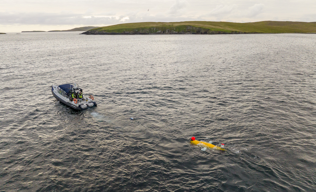
The National Oceanography Centre (NOC), working with the University of Southampton and the Department for Environment, Food and Rural Affairs (Defra), recently completed a Fully Autonomous Marine Protected Area Seafloor Survey.
This survey will help with understanding the suitability of using autonomous underwater vehicles for UK offshore marine monitoring, and establish to what extent such systems can help the UK Government meet its increasing marine monitoring ambitions.
NOC conducted the fully autonomous seafloor survey of the Central Fladen Nature Conservation Marine Protected Area, which is located some 140 km south-southeast of Lerwick (Shetland), using an Autosub Long Range (ALR), famously known as ‘Boaty McBoatface’ launched from shore.
The ALR carried the University of Southampton’s ‘BioCam’ instrument, a three-dimensional seafloor imaging system that comprises a stereo pair of cameras, dual LED strobes, and dual line lasers.
Operated together, these instruments generate georeferenced, colour corrected conventional still images, as well as texture maps and corresponding microtopographic maps of the seafloor.
The data gathered will enable subsequent assessment of seafloor type and condition, the abundance and identity of seafloor related fish and larger invertebrate animals, and provide evidence of human impacts on the seabed environment (physical disturbance of seabed by trawling and presence of litter for example).
The survey is therefore providing natural capital and conservation relevant information on asset extent, condition, and human pressures.
This project is part of Defra’s Marine Natural Capital and Ecosystem Assessment (mNCEA) programme, which is supporting the adoption of innovative marine monitoring technologies.
These technologies will help to deliver the ‘Big Data’ needed in advanced data-driven machine learning for mapping and assessment of our marine natural capital and the benefits it provides.
NOC scientists have been using autonomous underwater vehicles as key tools for gathering ocean data for over 20 years, and this mission demonstrates one of the many potential commercial applications of the ALR’s cutting-edge technology.
The fully autonomous approach made possible by using a shore launched ALR enables offshore marine environmental surveys to be completed without requiring a survey ship, significantly reducing costs whilst supporting Net Zero initiatives.
Additionally, the use of ALRs has the potential to generate higher quality seafloor mapping data and seafloor photography than comparable systems deployed by wire from a survey ship.
This survey builds on the success and learnings of the previous AT-SEA missions, which demonstrated ALRs capability to undertake ecological surveys in end-of-life oil fields. The ability to use ALRs for high-tech, low impact marine surveying and monitoring projects negates the need for a traditional survey ship and crew, generating improved quality and quantity of information at a significantly reduced cost.
Following the successful recovery of the raw data gathered during the survey, work now continues to produce data products informing users about the current conditions of the MPA.
Project lead and National Oceanography Centre scientist, Dr Brian Bett, explained; “The UK has around a quarter of a million square kilometres of offshore marine protected areas, which is equal to the total land surface of the UK.
“Finding an effective and efficient method of monitoring these areas is challenging, with autonomous vehicles likely to play a key role.”


