Connect with Leading Marine Technology Innovators
Discover cutting-edge solutions from leading global suppliers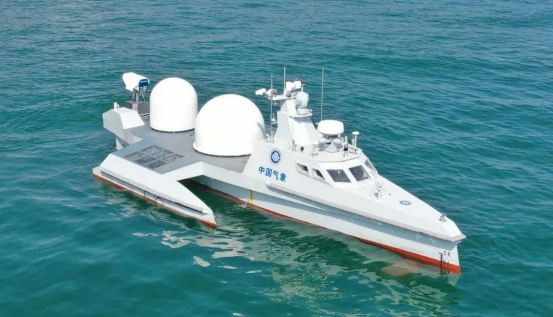
The 716th Research Institute of China State Shipbuilding Corporation successfully launched a multi-band cloud and fog observation uncrewed vessel.
It sailed from the Lianyungang Maritime Safety Administration supervision base in Jiangsu Province into the Yellow Sea and successfully carried out a three-dimensional cloud and fog observation at sea.
The total voyage was 110 nautical miles and lasted 16 hours, the first time that China’s independently developed uncrewed meteorological ship has carried out a long-range voyage observation test.
As a result, China has acquired the ability to observe large-scale meteorological and hydrological observations at sea.
The 12m boat has a displacement of 9 tons and an endurance of 400 nautical miles, and is able to sail safely in high sea conditions.
It is in use by the China Meteorological Administration Meteorological Detection Center in conjunction with the 716th Institute, Chengdu University of Information Science and Technology, and the National Space Science Center of the Chinese Academy of Sciences.
The maritime multi-band cloud and fog observation equipment was developed by nine organizations, including the Meteorological Center, and has the ability to achieve mobile detection of cloud and fog in the middle and far seas.
The equipment can solve the problem of insufficient maritime observation capabilities and lack of cloud and fog observation data, obtaining observation data on the sea fog generation and dissipation process, and revealing characteristics and parameters of these processes.
The vessel’s maneuverability ensures that the unmanned boat can complete long-duration detection in designated areas, and the observation range can be extended to about 180 nautical miles from the shore.
When high-impact weather occurs at sea, the unmanned ship can be directed to the target area – according to the observation needs of the weather-affected and forecast-sensitive areas – to carry out multi-element meteorology such as cloud height, cloud cover, sea fog, visibility, sea surface temperature, and sea salt.
Observations can also be carried out in conjunction with meteorological satellites, shore-based radars, and others to expand the scope of the observation area and improve accuracy.
Since the establishment of the project, the 716th Institute has attached great importance to it and employed highly-qualified troops to carrying out the technical research. The Institute has made the comprehensive use of multiple active and passive anti-rolling devices a reality on this unmanned platform, and has also upgraded the independent control algorithm to adapt to high sea conditions.
The project team worked together to conduct a vast array of research on the technology, load integration, navigation control, and more, combining simulation calculations with ship model pools and sea trials for experimental verification. Construction and launch occurred in June 2023.

