


Discover World-Leading Technologies for Ocean Science
Discover cutting-edge solutions from leading global suppliers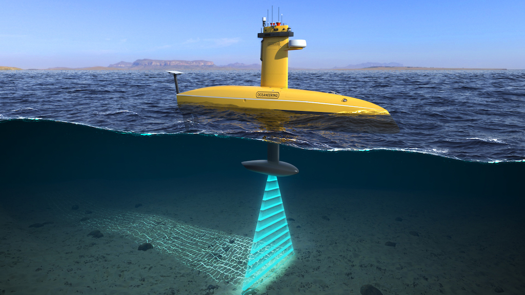
Oceaneering International has announced that its Subsea Robotics group is introducing a new Uncrewed Surface Vessel (USV) service to support remote survey work scopes.
Exail and Oceaneering have reached an agreement for Oceaneering to purchase its first DriX USV to support deepwater geophysical and asset inspection operations, including autonomous underwater vehicle (AUV) positioning, and offshore and nearshore surveys.
The use of the DriX USV on offshore survey and inspection work scopes will enable Oceaneering to improve operational efficiencies, reduce overall vessel time on site, and significantly reduce carbon emissions.
DriX USV has accumulated several thousand hours in operation since entering service in 2016. It can conduct over-the-horizon supervised autonomous operations thanks to its A.I powered CortiX software, its state-of-the-art sensors and its Communication suite. The Communication suite comprises of conventional radios, 5G, and Starlink Satellite Communication system while offering outstanding seakeeping and speed capabilities.
The USV’s shape and stability allows for continued operations alongside Oceaneering’s AUVs in poor sea conditions found offshore (up to sea state 5) without compromising data quality.
The USV’s speed and endurance also reduces transit downtime and enables high speed nearshore surveys to be conducted, maintaining optimal data quality harvested in a fraction of the usual times. It also offers a lower environmental footprint at only 2 liters of fuel usage per hour, reducing carbon emissions.
Oceaneering’s USV service will utilize dual independent positioning correction services from Oceaneering’s C-NAV® group for uninterrupted operations, improving reliability. The company says its service will be the only USV equipped with true, dual redundancy for guaranteed continuity of service.
Eric Smith, Senior Director of Survey Services at Oceaneering, said: “It is the natural progression of our extensive experience with remote operations that we combine USVs with Oceaneering’s existing ROV and AUV fleets and onshore remote operations centers to deliver significant opportunities to scale operations and drive greater efficiencies. The service will directly support the market growth of IMRGETM, our integrated and customizable Inspection, Maintenance and Repair (IMR) strategy.”
Martin McDonald, Senior Vice President of Subsea Robotics, said: “We are excited to use DriX USV as part of our integrated service offerings and to pair it with our AUV systems, such as the FreedomTM vehicle. DriX allows us to remotely gather the same high-quality data at a lower operational impact, without the need for an offshore-based crew. This reduces health, safety, and environmental risks while freeing up multi-service vessels to complete other tasks.”
Olivier Cervantes, Vice President of Maritime Autonomy at Exail, said: “Oceaneering and Exail have a long-term partnership. It is a great pleasure to collaborate now on expanding subsea exploration thanks to automated systems such as DriX and Freedom. This collaboration opens new capabilities in the subsea construction, inspection, and survey domains.”


