Drones Map Tide-Exposed Coral Reefs

A new study from AIMS and the University of Western Australia highlights the potential of drones as a tool to monitor intertidal reefs, usually under-represented in monitoring programs By Abi Wylie / 05 Jun 2024

Discover World-Leading Technologies for Ocean Science

Discover cutting-edge solutions from leading global suppliers
SUPPLIER SPOTLIGHT
Drones Map Tide-Exposed Coral Reefs
Follow OS&T

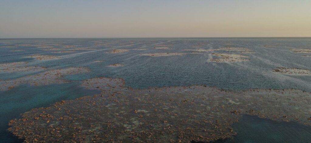
Cutting-edge analytical methods and drone technology have been used for the first time in a new study to map the intertidal coral reefs of the Rowley Shoals off the Kimberley coast of Western Australia. 

The research, by The University of Western Australia and the Australian Institute of Marine Science (AIMS) and published in Remote Sensing in Ecology and Conservation, highlights the potential of drones as a new tool to monitor intertidal reefs, which are usually challenging to access and therefore under-represented in traditional monitoring programs. 

Intertidal coral reefs are a crucial component of many reef systems and play a significant role in overall reef health. Their habitats experience dynamic changes between low and high tides, and organisms must adapt to survive both underwater and above-water conditions. 

Photo: JAMES GILMOUR

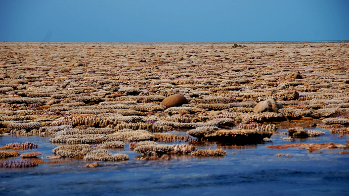
Co-author Dr Sharyn Hickey, from UWA’s Oceans Institute and Centre for Water and Spatial Science, said this type of reef had shown evidence of thermal adaptation and higher resistance to coral bleaching than coral in subtidal environments. 

“In the few studies conducted on intertidal reefs, the main impacts on them were found to be marine heatwaves driven by climate change and sea level rise, so they are an important element of coral reef systems to get to know better,” Dr Hickey said. 

Lead author, UWA graduate research assistant Amy Stone, compared machine learning and AI approaches to analyse drone-captured imagery of 3D reef structure, finding that the simplest methods were the most accurate in estimating coral cover; “The findings are important because we have lacked comparative studies to know how to best optimise drones as a tool to map coral reefs.”

Photo: AMY STONE

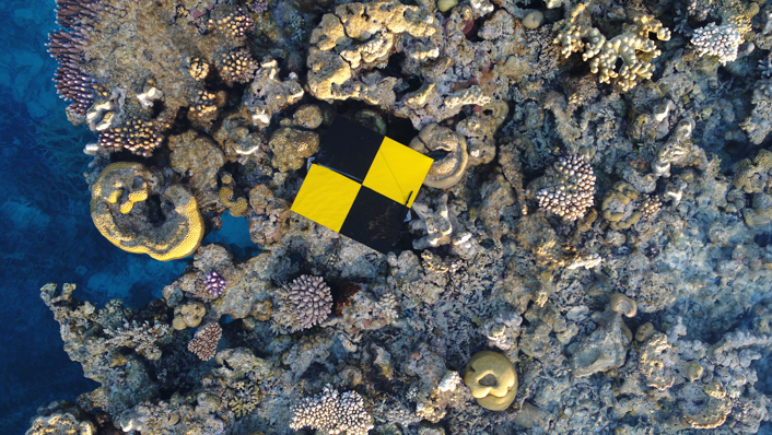
AIMS’ Dr Ben Radford, a senior researcher on the paper, said the work opened doors for more comprehensive and efficient monitoring of these vulnerable intertidal ecosystems; “This will aid in conservation efforts and further our understanding of their role within broader reef systems. By harnessing drone technology, we can enhance our understanding of these critical ecosystems and inform targeted management strategies.” 

The study was undertaken as part of AIMS@UWA, Indian Ocean Marine Research Centre ICoAST collaborative project, and the AIMS NorthWest Shoals to Shore research program, supported by Santos. 

Posted by Abi Wylie Edited by Abigail Wylie, Editor and Copywriter experienced in digital media with a keen interest in ocean science technology. Connect

Latest Articles

Profile Spotlight: IQUA Robotics for Autonomous Underwater Survey & Inspection

IQUA Robotics is presenting its hovering AUV technologies on OST, providing precise, maneuverable platforms for subsea mapping, inspection, and reconnaissance

Nov 20, 2025
Precision Terrain Modeling & Hydrological Analysis with Global Mapper

Blue Marble Geographics’ Global Mapper enables Egis to streamline digital terrain modeling and hydrological analysis, enhancing data processing efficiency across large-scale environmental projects

Nov 20, 2025
Real-Time Vibration Analysis Embedded in SBG Systems IMU

SBG Systems’ IMU now features built-in vibration monitoring, delivering real-time analysis to enhance accuracy, detect resonance, and support design, testing, and structural monitoring

Nov 19, 2025
Kraken Robotics Forms Reseller Partnership to Expand Access to Subsea Sonar Technology

Kraken Robotics has appointed BlueZone Group as an authorized reseller of its SAS and KATFISH platform, offering high-resolution underwater imaging, bathymetric mapping, and rapid data collection for defense and commercial surveys in Australia and New Zealand

Nov 19, 2025
Monitoring Marine Environments with Pro-Oceanus Dissolved Gas Sensors

Discover how Pro-Oceanus Systems’ advanced sensors help explore the oceans, measure dissolved gases, and uncover critical insights into marine and climate processes

Nov 18, 2025
Strategic Partnership to Deliver High-Resolution Deep-Sea Seafloor Intelligence & Insights

PlanBlue and Orpheus Ocean have collaborated to integrate advanced AI-driven imaging with autonomous underwater vehicles, enabling enhanced monitoring and analysis of critical deep-sea environments

Nov 17, 2025

Featured Content

FarSounder Integration Delivers Real-Time Seafloor & Obstacle Detection to SYNAPSIS Users

FarSounder has integrated its Argos 3D Forward Looking Sonar with Anschütz’s SYNAPSIS navigation platform, bringing real-time subsurface insights directly into the (W)ECDIS NX interface

Nov 17, 2025
Boxfish ROV Captures Marine Research Footage for Upcoming Premiere

Scientists from the University of Tasmania used a custom Boxfish ROV to survey Beagle Marine Park, capturing underwater footage premiering on YouTube this November

Nov 12, 2025
SubC Imaging Observatory Camera Systems Support Long-Term Ocean Observation

SubC Imaging’s Observatory Camera Systems capture detailed subsea imagery for cabled ocean observatories, enabling continuous observation and long-term marine environmental studies

Nov 11, 2025