Topobathymetric Dataset Powered by Teledyne Lidar System Published

Dewberry surveyed 55 miles of the Potomac River using Teledyne’s Optech CZMIL SuperNova lidar system, acquiring 12.5 square miles of submerged topobathymetric lidar data By Abi Wylie / 10 Jan 2024

Underwater LiDAR

Discover cutting-edge solutions from leading global suppliers
SUPPLIER SPOTLIGHT
Topobathymetric Dataset Powered by Teledyne Lidar System Published
Follow OS&T

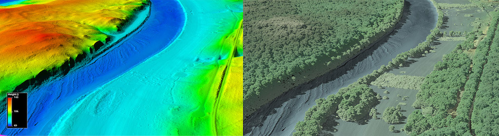
A new topobathymetric lidar dataset for the Potomac River has been collected using Teledyne’s Optech CZMIL SuperNova lidar system, and published by the U.S. Geological Survey (USGS).

Dewberry, a privately held professional services firm, surveyed 55 miles of the Potomac River from Hancock, MD down to Shepherdstown, WV, acquiring a total of 12.5 square miles of submerged topobathymetric lidar data. 

The project deliverables included a 3D point cloud and seamless topobathymetric Digital Elevation Models (DEMs) for that section of the river.

This was the 2nd Potomac River project, with the first extending from Shepherdstown, WV to the Little Falls dam near Washington, D.C. 

It is expected that these maps will provide a much-needed tool to predict the presence and movement of oil spills in the Potomac River and support ICPRB’s mission to protect and enhance the waters and related resources of the Potomac River basin through science, regional cooperation, and education.

The project required an aggregate nominal point density (ANPD) of 1.5 points/m2 in shallow water (~1.5x secchi depth). The survey was able to exceed this specification and deliver 6.25 points/m2. 

The topographic portion of this dataset was tested to meet ASPRS Positional Accuracy Standards for Digital Geospatial Data (2014) for a 10 cm RMSEz Vertical Accuracy Class. Actual non-vegetated vertical accuracy was found to be 8.8 cm (RMSEz). The bathymetric vertical accuracy was found to be 6.1 cm (RMSEz), equating to ± 12.0 cm at 95% confidence level.

The Potomac River flows from the Potomac Highlands in West Virginia to the Chesapeake Bay in Maryland. The lidar survey was conducted for USGS’s 3D Elevation Program (3DEP), with stakeholders including the USGS Earth Resources Observation and Science Center (EROS), National Geospatial Program (NGP), and Eastern Ecological Science Center (EESC) programs, as well as the Interstate Commission on the Potomac River (ICPRB).

“Given the depths, water conditions, and bottom substrate of the Potomac River, we were hopeful we’d get bottom returns with the enhanced CZMIL SuperNova system and couldn’t have been happier with the level of complete, seamless coverage achieved,” said Emily Klipp, Dewberry Senior Associate and Senior Project Manager.

Malek Singer, Airborne Product Manager at Teledyne Geospatial, added; “I am very pleased to see the CZMIL SuperNova take on another challenging riverine environment mapping its banks and bed with such high detail. Congratulations to Dewberry for this great success in topo-bathymetric data production!”

Posted by Abi Wylie Edited by Abigail Wylie, Editor and Copywriter experienced in digital media with a keen interest in ocean science technology. Connect

Latest Articles

Real-Time Vibration Analysis Embedded in SBG Systems IMU

SBG Systems’ IMU now features built-in vibration monitoring, delivering real-time analysis to enhance accuracy, detect resonance, and support design, testing, and structural monitoring

Nov 19, 2025
Kraken Robotics Forms Reseller Partnership to Expand Access to Subsea Sonar Technology

Kraken Robotics has appointed BlueZone Group as an authorized reseller of its SAS and KATFISH platform, offering high-resolution underwater imaging, bathymetric mapping, and rapid data collection for defense and commercial surveys in Australia and New Zealand

Nov 19, 2025
Monitoring Marine Environments with Pro-Oceanus Dissolved Gas Sensors

Discover how Pro-Oceanus Systems’ advanced sensors help explore the oceans, measure dissolved gases, and uncover critical insights into marine and climate processes

Nov 18, 2025
Strategic Partnership to Deliver High-Resolution Deep-Sea Seafloor Intelligence & Insights

PlanBlue and Orpheus Ocean have collaborated to integrate advanced AI-driven imaging with autonomous underwater vehicles, enabling enhanced monitoring and analysis of critical deep-sea environments

Nov 17, 2025
FarSounder Integration Delivers Real-Time Seafloor & Obstacle Detection to SYNAPSIS Users

FarSounder has integrated its Argos 3D Forward Looking Sonar with Anschütz’s SYNAPSIS navigation platform, bringing real-time subsurface insights directly into the (W)ECDIS NX interface

Nov 17, 2025
Underwater Optical Communication Showcases 5.2 Gbps Transmission for Marine Applications

Kyocera has demonstrated a high-speed Underwater Wireless Optical Communication (UWOC) technology capable of transmitting data at 5.2 Gbps, enabling real-time, large-volume data exchange for underwater vehicles and ocean exploration

Nov 14, 2025

Featured Content

FarSounder Integration Delivers Real-Time Seafloor & Obstacle Detection to SYNAPSIS Users

FarSounder has integrated its Argos 3D Forward Looking Sonar with Anschütz’s SYNAPSIS navigation platform, bringing real-time subsurface insights directly into the (W)ECDIS NX interface

Nov 17, 2025
Boxfish ROV Captures Marine Research Footage for Upcoming Premiere

Scientists from the University of Tasmania used a custom Boxfish ROV to survey Beagle Marine Park, capturing underwater footage premiering on YouTube this November

Nov 12, 2025
SubC Imaging Observatory Camera Systems Support Long-Term Ocean Observation

SubC Imaging’s Observatory Camera Systems capture detailed subsea imagery for cabled ocean observatories, enabling continuous observation and long-term marine environmental studies

Nov 11, 2025