Software Launched for Enhanced Tuna Detection

Dawn Sounding Detail is a new MSB+ software functionality from Marine Instruments, increasing the sounding capacity of sonar buoys at dawn for more accurate tuna identification By Abi Wylie / 18 Jul 2024

Marine Plankton Sampler Equipment

Discover cutting-edge solutions from leading global suppliers
SUPPLIER SPOTLIGHT
Follow OS&T

Marine Instruments has recently launched Dawn Sounding Detail, a new MSB+ software functionality that increases the sounding capacity by 10x during dawn for more accurate identification of tuna. 

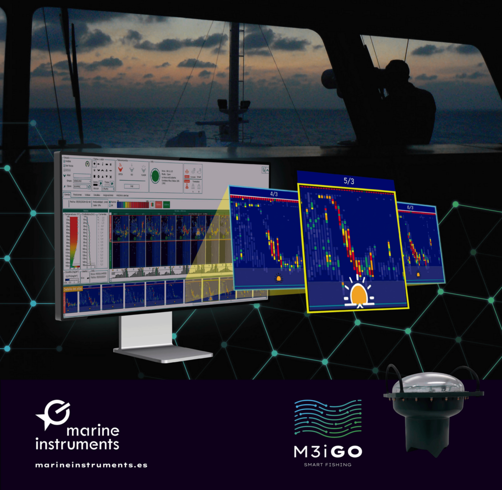
This update, already integrated into the MSB+ software used to integrate oceanographic information and management of the M3iGO satellite sonar buoy, represents a significant advancement in acoustic visualization for the skipper and fleets of tuna vessels. 

This innovation is the result of Marine Instruments’ required identification and analysis process, as well as collaboration between tuna fishing professionals and Marine Instruments’ engineers and advisors.

This innovation significantly improves sounding capacity during dawn, a critical time of day in tuna fishing, enhancing tuna identification and showing clear movements better distinguishing tuna from zooplankton and bait.

This feature, installed on tropical tuna vessels, has received positive feedback from users, who consider it a highly useful tool for tuna fishing. Combined with the experience of the skippers, Dawn Sounding Detail leads to more efficient fishing, a result of Marine Instruments’ ongoing collaboration with the tuna industry.

The M3iGO satellite sonar buoy itself was designed and manufactured by Marine Instruments, and continues to evolve. In addition to Dawn Sounding Detail, the company has incorporated other updates into its buoy management software to make the software increasingly user-friendly and intuitive. 

Posted by Abi Wylie Edited by Abigail Wylie, Editor and Copywriter experienced in digital media with a keen interest in ocean science technology. Connect

Latest Articles

Profile Spotlight: IQUA Robotics for Autonomous Underwater Survey & Inspection

IQUA Robotics is presenting its hovering AUV technologies on OST, providing precise, maneuverable platforms for subsea mapping, inspection, and reconnaissance

Nov 20, 2025
Precision Terrain Modeling & Hydrological Analysis with Global Mapper

Blue Marble Geographics’ Global Mapper enables Egis to streamline digital terrain modeling and hydrological analysis, enhancing data processing efficiency across large-scale environmental projects

Nov 20, 2025
Real-Time Vibration Analysis Embedded in SBG Systems IMU

SBG Systems’ IMU now features built-in vibration monitoring, delivering real-time analysis to enhance accuracy, detect resonance, and support design, testing, and structural monitoring

Nov 19, 2025
Kraken Robotics Forms Reseller Partnership to Expand Access to Subsea Sonar Technology

Kraken Robotics has appointed BlueZone Group as an authorized reseller of its SAS and KATFISH platform, offering high-resolution underwater imaging, bathymetric mapping, and rapid data collection for defense and commercial surveys in Australia and New Zealand

Nov 19, 2025
Monitoring Marine Environments with Pro-Oceanus Dissolved Gas Sensors

Discover how Pro-Oceanus Systems’ advanced sensors help explore the oceans, measure dissolved gases, and uncover critical insights into marine and climate processes

Nov 18, 2025
Strategic Partnership to Deliver High-Resolution Deep-Sea Seafloor Intelligence & Insights

PlanBlue and Orpheus Ocean have collaborated to integrate advanced AI-driven imaging with autonomous underwater vehicles, enabling enhanced monitoring and analysis of critical deep-sea environments

Nov 17, 2025

Featured Content

FarSounder Integration Delivers Real-Time Seafloor & Obstacle Detection to SYNAPSIS Users

FarSounder has integrated its Argos 3D Forward Looking Sonar with Anschütz’s SYNAPSIS navigation platform, bringing real-time subsurface insights directly into the (W)ECDIS NX interface

Nov 17, 2025
Boxfish ROV Captures Marine Research Footage for Upcoming Premiere

Scientists from the University of Tasmania used a custom Boxfish ROV to survey Beagle Marine Park, capturing underwater footage premiering on YouTube this November

Nov 12, 2025
SubC Imaging Observatory Camera Systems Support Long-Term Ocean Observation

SubC Imaging’s Observatory Camera Systems capture detailed subsea imagery for cabled ocean observatories, enabling continuous observation and long-term marine environmental studies

Nov 11, 2025