


Marine Plankton Sampler Equipment
Discover cutting-edge solutions from leading global suppliers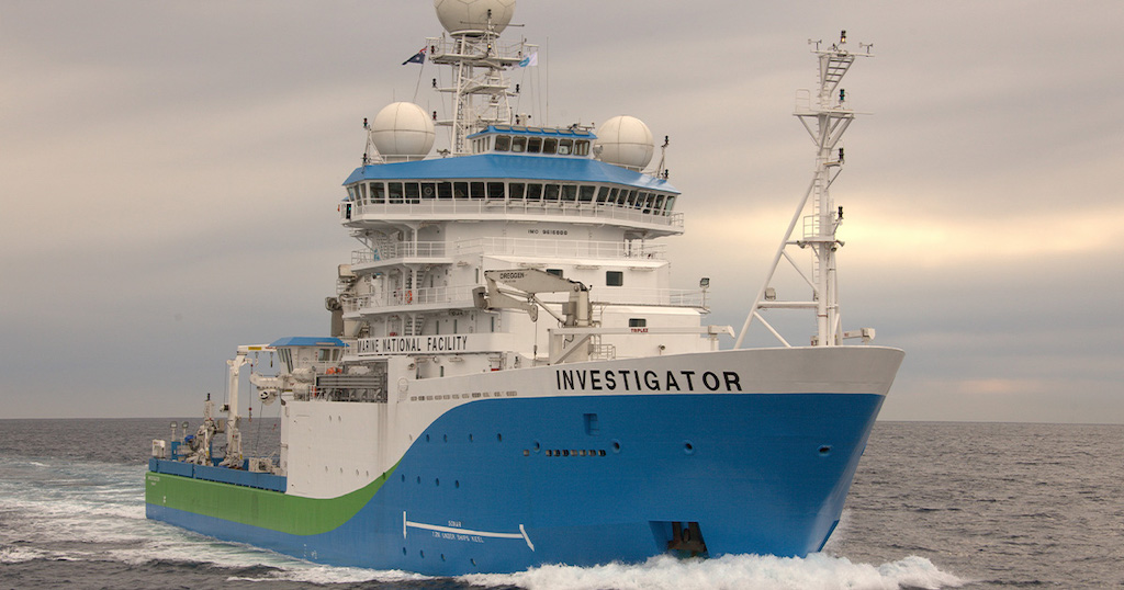
CSIRO’s research vessel (RV) Investigator sets off today on the longest voyage in its 10-year history to the Southern Ocean and sea-ice edge.
The aim of the 60-day voyage is to improve humans’ ability to anticipate the impacts of future climate change.
The science teams on board, led by the Australian Antarctic Program Partnership (AAPP) and Australia’s national science agency, CSIRO, will search for climate clues between the deep ocean, up to six kilometres below the water surface, to low-lying clouds, two kilometres above in the atmosphere.
The voyage, known as MISO (for ‘Multidisciplinary Investigations of the Southern Ocean’), will explore how links between physics, biogeochemistry, plankton, aerosols, and clouds influence the Earth’s climate. It will begin at Hobart and sail south to the edge of the Antarctic ice, travelling 9,260km before returning to Fremantle in early March.
The Southern Ocean takes up more of the heat and carbon added by human activities than any other latitude band on the earth.
Changes in the Southern Ocean would have profound implications, influencing the rate of climate change, the productivity of the Antarctic ecosystem, and the future of the Antarctic Ice Sheet. Changes in the Antarctic Ice Sheet, in turn, would affect the rate of sea level rise.
Recently published research has shown the “overturning circulation” of Antarctic waters driving global ocean currents may be slowing down, affecting the redistribution of heat, carbon and nutrients across the globe.
This research is supported by a grant of sea time on RV Investigator from the CSIRO Marine National Facility which is supported by the Australian Government’s National Collaborative Research Infrastructure Strategy (NCRIS).
This voyage is supported by the Australian Antarctic Program Partnership (AAPP). The AAPP is funded by the Australian Government through the Antarctic Science Collaboration Initiative to better understand the role of the Antarctic region in the global climate system and the implications for marine ecosystems.
The AAPP is a 10-year program established in July 2019 and is led by the University of Tasmania with core partners the Australian Antarctic Division, CSIRO, and the Bureau of Meteorology.
Scientists onboard RV Investigator from the University of Tasmania and the Bureau of Meteorology will also study gases and particles released by tiny marine organisms called phytoplankton, grown in special aquariums mounted on the ship’s deck.
Gases and particles (or aerosols) released by the phytoplankton will be analysed to see how effectively they act as ‘seeds’ for new clouds.
Dr Marc Mallet, of the University of Tasmania, said understanding cloud formation in the southern hemisphere was a blind spot for climate science and model projections; “This voyage will test the hypothesis that aerosols released by phytoplankton ’seed’ clouds and explain the unique properties of the Southern Ocean atmosphere.
“Improved understanding of cloud formation in the region will provide the foundation for more skilful weather and climate projections for Australia and the rest of the globe.”
Co-Chief Scientist Dr Steve Rintoul, of CSIRO and AAPP, said the Southern Ocean takes up vast amounts of heat and carbon dioxide and acts as a handbrake on climate change, which means it has a profound influence on climate patterns in Australia and the rest of the globe; “To anticipate how climate and sea level will change in the future, we need to understand how the Southern Ocean works and how sensitive it is to change.
“What’s amazing about the Southern Ocean is that everything is interconnected – we can’t hope to understand how the region influences climate unless we measure each piece and how it fits with the other parts of the system.”
Co-Chief Scientist Dr Annie Foppert from the Australian Antarctic Program Partnership at the University of Tasmania said the meltwater from the Antarctic Ice sheet is reducing the amount of dense water sinking to the deep ocean around Antarctica, slowing ocean currents that control climate; “Data collected on the MISO voyage will be compared to earlier measurements to track how the Southern Ocean is changing and what it means for climate and sea level rise.”
“To track these changes in the deep ocean, we will deploy a dozen deep-diving robots. These new floats, able to collect measurements down to six kilometres below the sea surface, will allow us to track how the ocean is changing for the next five years by profiling the full depth of the ocean.”


