


Discover World-Leading Technologies for Ocean Science
Discover cutting-edge solutions from leading global suppliers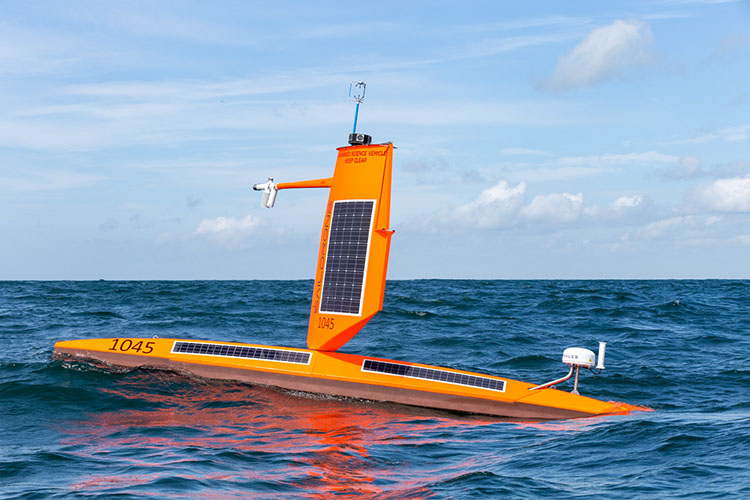
Saildrone Explorer SD 1045 measured the “highest wind speed recorded by a USV” during Hurricane Sam in 2021.
SD 1045 made global headlines when it spent 24 hours inside Category 4 Hurricane Sam, delivering the world’s first video footage from inside a major hurricane barreling across the Atlantic Ocean.
As it passed through the eyewall of the storm, SD 1045 measured 109.83 knots (126.4 mph) of wind speed, which has been officially determined to be the “highest wind speed recorded by an uncrewed surface vehicle,” a new entry in the 2024 edition of the Guinness Book of World Records.
The Technology
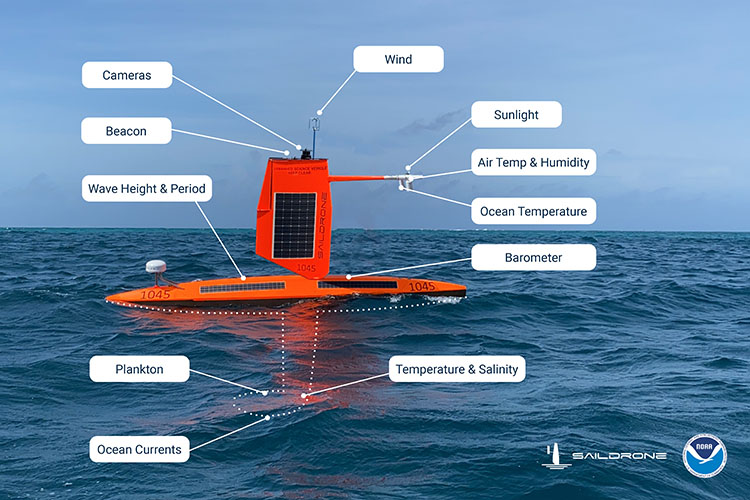
SD 1045 is an Explorer-class USV designed, manufactured, and operated by Saildrone. Saildrone Explorers are 7 meters long and typically have a 5-meter-tall wing sail, similar to an airplane wing, which provides forward propulsion.
The Explorers used for extreme weather monitoring like the NOAA Atlantic Hurricane mission are equipped with a shorter, more robust “hurricane” wing, specially designed to withstand the conditions inside a tropical cyclone.
The company believes Saildrone Explorers are the only vehicles capable of collecting atmospheric, surface, and upper ocean data inside a hurricane on broad temporal and spatial scales.
The combination of near-real-time hurricane observations of the air-sea interface had not been available from ocean surface vehicles until Saildrone and NOAA’s successful 2021 mission.
Hurricane conditions are far too dangerous and destructive for crewed ships, and atmospheric probes dropped from aircraft collect only atmospheric data and only at a single point. Saildrone USVs, powered exclusively with renewable energy, sail autonomously into and out of the hurricane with a zero operational carbon footprint.
During these missions, NOAA has orchestrated coordinated sampling by aerial, surface, and sub-surface assets to create a complete picture of a storm, from 30,000 feet above the surface, to several thousand feet below, with the saildrones as the link at the air-sea interface.
The Science
The Atlantic Hurricane mission is part of ongoing NOAA research into how and why some relatively mild tropical storms rapidly intensify into major hurricanes, which is particularly destructive when it happens just before landfall.
Hurricane track forecasting has steadily improved in recent years. However, predicting rapid intensification—when wind speeds increase at least 35 mph over a 24-hour period—is still a significant challenge.
To understand how these large and destructive storms grow, scientists need to collect data about the surface fluxes—the exchanges of energy in the forms of heat and momentum—a task that Saildrone’s uncrewed surface vehicles (USVs) are uniquely equipped to perform.
Battling massive waves and sustained winds over 100 mph, SD 1045 not only survived intact but collected important data about the physical interactions between the ocean and atmosphere that revealed salinity may play a role in fueling the storm.
“To me, this was a really exciting thing. To see the data continuously streaming in through the hurricane without interruptions, despite the extremely harsh conditions—it was a highlight of my career,” said Greg Foltz, a NOAA oceanographer and one of the mission’s principal investigators.
Back On Mission
SD 1045 vehicle returns to duty this summer, one of 12 vehicles deployed for the 2023 mission, and is stationed off the coast of South Carolina in a particularly complex area of the ocean where relatively shallow waters combined with the strong, warm currents of the Gulf Stream supply energy to passing storms.
The National Hurricane Center included observations from SD 1045 in its August 30 bulletin as Tropical Storm Idalia passed over South Carolina.
The data will also be archived by NOAA’s National Environmental Satellite, Data and Information Service (NESDIS) and sent by NOAA to the World Meteorological Organization (WMO)’s Global Telecommunication System (GTS), where it is available for the world’s major forecast centers—some 20 agencies worldwide, including NOAA.
“This record is a testament to the unique endurance of the Saildrone platform. We are proud to have engineered a vehicle capable of operating in the most extreme weather conditions on earth, to deliver data that can help to advance understanding of these powerful storms and protect our coastal communities,” said Saildrone Founder and CEO Richard Jenkins.


