Next-Gen Underwater Lidar Technology for Detailed Mapping of Ocean Floor

The partnership between the Monterey Bay Aquarium Research Institute (MBARI) and 3D at Depth aims to create the next generation of subsea lidar technology that can generate detailed high-resolution maps of underwater features By Joe Macey / 04 Jul 2023

Underwater LiDAR

Discover cutting-edge solutions from leading global suppliers
SUPPLIER SPOTLIGHT
Follow OS&T

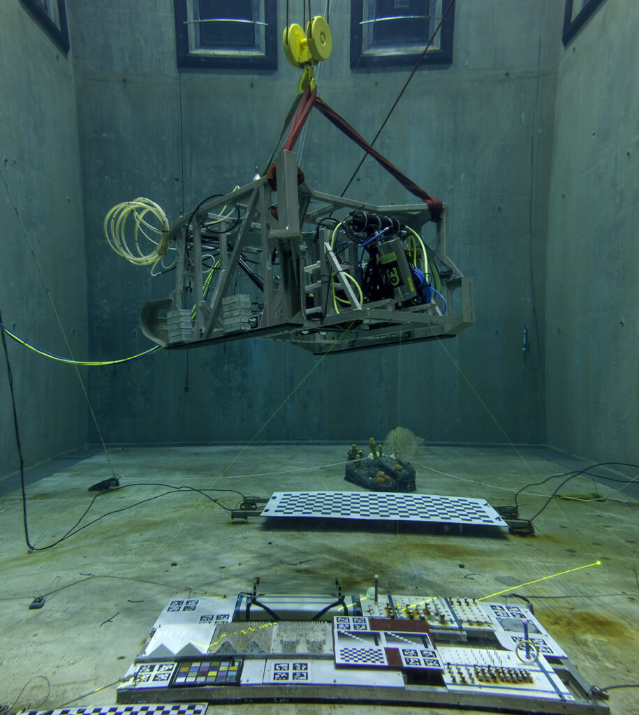
The Monterey Bay Aquarium Research Institute (MBARI), a non-profit oceanographic research center, is working with 3D at Depth, a leader in commercial subsea LiDAR laser technology, to deliver a new design for a next generation Subsea Lidar customized for marine science applications.

If successful, fabrication of the next generation system will begin later this year.

MBARI began testing 3D at Depth’s technology with the first-generation subsea LiDAR system (the SL1) in 2013 and incorporated the sensor into the institute’s Low-Altitude Survey System (LASS) that can be attached to MBARI’s remotely operated vehicles to map and image the deep ocean floor. 

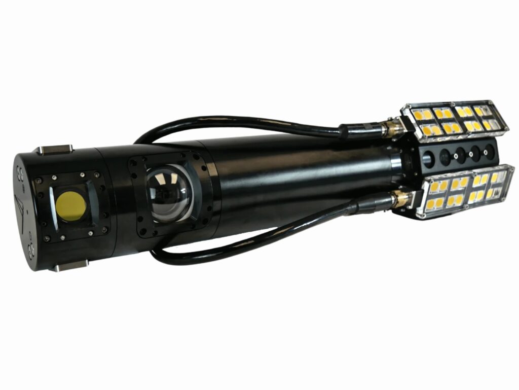
In 2017, 3D at Depth delivered a 4000m depth rated Wide Swath Subsea LiDAR (WiSSL) to meet the custom requirements for MBARI’s seabed mapping work. Starting in 2018, MBARI’s Seafloor Mapping Lab has used the WiSSL and LASS to map a variety of seafloor features and habitats at centimeter scale, including methane gas seeps, faults, submarine canyons, deep-sea coral and sponge communities, octopus brooding sites, and high-temperature hydrothermal vents.

According to MBARI, its mission is to advance marine science and engineering to understand a changing ocean. Visualizing the structure of the seafloor is critical to understanding the biology and ecology of the ocean. The success of the WiSSL and LASS has allowed MBARI and 3D at Depth to demonstrate the benefits of efficient 1-cm-scale swath mapping in the deep ocean. 

Ultimately, MBARI plans to incorporate the low-altitude survey capability on autonomous platforms to achieve efficient centimeter-scale surveys of the deep ocean floor. To this effort, MBARI is collaborating with 3D at Depth to develop the next generation system that provides enhanced capabilities in a smaller package capable of AUV deployments.

Dave Caress, Principal Investigator for MBARI’s Seafloor Mapping Lab, said: “Our desire to achieve 1-cm-scale surveys of areas with complex and rugged terrain requires generating precise bathymetry over altitudes from 2-m to 10-m, while our need for efficient use of expensive platforms requires a scan rate and a field of view comparable to other swath mapping sensors. Achieving this performance with a LiDAR that is smaller, lighter, and uses less power will enable us to integrate the system into smaller subsea vehicles, and ultimately to make fundamental new observations in the deep ocean in support of our benthic ecology and marine geology research programs.”

Carl Embry, CEO of 3D at Depth, added: “We are excited that a research organization such as MBARI continues to use and invest in our technology to meet one of their strategic goals. These projects are truly a win-win for both organizations as it provides MBARI with a tool to meet their scientific goals and this helps us accelerate the development of our next generation Subsea LiDAR (SL) systems for moving AUVs and ROVs.”

Posted by Joe Macey Joseph Macey is a Content Specialist at Ocean Science & Technology, where he has focused on emerging marine technologies since joining in 2022. He brings particular expertise in autopilot systems, AUVs, and subsea imaging. A graduate of Falmouth University in Journalism, Joseph began his career in 2019 as a local reporter. His background in journalism not only hones his reporting skills but also strengthens his ability to conduct in-depth interviews, allowing him to provide authoritative insights on the latest industry trends. Connect

Latest Articles

Profile Spotlight: IQUA Robotics for Autonomous Underwater Survey & Inspection

IQUA Robotics is presenting its hovering AUV technologies on OST, providing precise, maneuverable platforms for subsea mapping, inspection, and reconnaissance

Nov 20, 2025
Precision Terrain Modeling & Hydrological Analysis with Global Mapper

Blue Marble Geographics’ Global Mapper enables Egis to streamline digital terrain modeling and hydrological analysis, enhancing data processing efficiency across large-scale environmental projects

Nov 20, 2025
Real-Time Vibration Analysis Embedded in SBG Systems IMU

SBG Systems’ IMU now features built-in vibration monitoring, delivering real-time analysis to enhance accuracy, detect resonance, and support design, testing, and structural monitoring

Nov 19, 2025
Kraken Robotics Forms Reseller Partnership to Expand Access to Subsea Sonar Technology

Kraken Robotics has appointed BlueZone Group as an authorized reseller of its SAS and KATFISH platform, offering high-resolution underwater imaging, bathymetric mapping, and rapid data collection for defense and commercial surveys in Australia and New Zealand

Nov 19, 2025
Monitoring Marine Environments with Pro-Oceanus Dissolved Gas Sensors

Discover how Pro-Oceanus Systems’ advanced sensors help explore the oceans, measure dissolved gases, and uncover critical insights into marine and climate processes

Nov 18, 2025
Strategic Partnership to Deliver High-Resolution Deep-Sea Seafloor Intelligence & Insights

PlanBlue and Orpheus Ocean have collaborated to integrate advanced AI-driven imaging with autonomous underwater vehicles, enabling enhanced monitoring and analysis of critical deep-sea environments

Nov 17, 2025

Featured Content

FarSounder Integration Delivers Real-Time Seafloor & Obstacle Detection to SYNAPSIS Users

FarSounder has integrated its Argos 3D Forward Looking Sonar with Anschütz’s SYNAPSIS navigation platform, bringing real-time subsurface insights directly into the (W)ECDIS NX interface

Nov 17, 2025
Boxfish ROV Captures Marine Research Footage for Upcoming Premiere

Scientists from the University of Tasmania used a custom Boxfish ROV to survey Beagle Marine Park, capturing underwater footage premiering on YouTube this November

Nov 12, 2025
SubC Imaging Observatory Camera Systems Support Long-Term Ocean Observation

SubC Imaging’s Observatory Camera Systems capture detailed subsea imagery for cabled ocean observatories, enabling continuous observation and long-term marine environmental studies

Nov 11, 2025