Innovative Partnership to Complete Global Ocean Mapping

Exail has signed an MoU with the Nippon Foundation-GEBCO Seabed 2030 Project to enhance global ocean mapping efforts, and will contribute valuable bathymetric data using its innovative technologies By William Mackenzie / 24 Sep 2024

Discover World-Leading Technologies for Ocean Science

Discover cutting-edge solutions from leading global suppliers
SUPPLIER SPOTLIGHT
Innovative Partnership to Complete Global Ocean Mapping
Follow OS&T

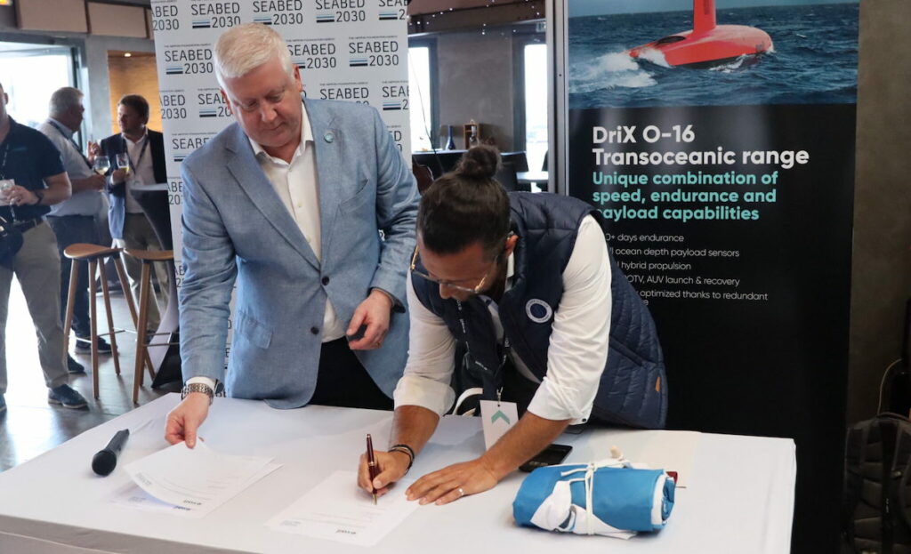
Subsea robotics, navigation and imagery solutions developer Exail has signed a Memorandum of Understanding (MoU) with The Nippon Foundation-GEBCO Seabed 2030 Project. 

The partnership aims to enhance global efforts in ocean bathymetry, contributing to the complete mapping of the world’s ocean floor by 2030.

Through the MoU, Exail and Seabed 2030 will work together to promote each other’s initiatives and share knowledge and best practices in ocean mapping and bathymetric data management.

The Seabed 2030 Project is a collaborative initiative between The Nippon Foundation and the General Bathymetric Chart of the Oceans (GEBCO). The project is dedicated to facilitating the full mapping of the global ocean floor and compiling all bathymetric data into the freely accessible GEBCO Ocean Map. 

This initiative is a vital part of understanding the world’s oceanic floor, which plays a key role in navigation, coastal management, and other applications including tsunami forecasting and environmental change monitoring.

As part of the agreement, Exail will contribute bathymetric data, promote the Seabed 2030 vision through its advanced technologies and solutions, and actively engage in promoting Seabed 2030 to the users of its sonar, navigation, and autonomy solutions.

David Vincentelli, autonomy business developer for the hydrographic market, at Exail, commented, “We are thrilled to collaborate with The Nippon Foundation-GEBCO Seabed 2030 Project.

“This partnership reflects our commitment to advancing ocean exploration and our belief in the importance of a complete and accurate map of the world’s ocean floors. By joining forces, we can accelerate progress toward a fully mapped ocean by 2030, benefiting not just our industry, but the entire planet.”

Seabed 2030 Project Director, Jamie McMichael-Phillips, added, “This partnership with Exail represents a significant milestone for Seabed 2030 as we continue to drive forward our mission of inspiring a complete map of the world’s ocean floor. Exail’s innovative solutions and expertise will not only enhance our technical capabilities, but also help raise awareness of the critical importance of ocean mapping. Together, we are committed to a better understanding of the ocean’s depths.”

Find suppliers and manufacturers of Side Scan Sonar for Ocean Mapping >>

Posted by William Mackenzie Will is a Content Specialist at Ocean Science Technology. Joining in 2024 with a background in professional copywriting and creative content, Will brings expertise in oceanographic monitoring, aquaculture, and environmental analysis. He provides in-depth coverage of breakthroughs in marine research, subsea systems, and autonomous platforms, drawing on his specialist understanding of ocean technology to highlight innovations shaping the future of the marine industry. Connect

Latest Articles

Profile Spotlight: IQUA Robotics for Autonomous Underwater Survey & Inspection

IQUA Robotics is presenting its hovering AUV technologies on OST, providing precise, maneuverable platforms for subsea mapping, inspection, and reconnaissance

Nov 20, 2025
Precision Terrain Modeling & Hydrological Analysis with Global Mapper

Blue Marble Geographics’ Global Mapper enables Egis to streamline digital terrain modeling and hydrological analysis, enhancing data processing efficiency across large-scale environmental projects

Nov 20, 2025
Real-Time Vibration Analysis Embedded in SBG Systems IMU

SBG Systems’ IMU now features built-in vibration monitoring, delivering real-time analysis to enhance accuracy, detect resonance, and support design, testing, and structural monitoring

Nov 19, 2025
Kraken Robotics Forms Reseller Partnership to Expand Access to Subsea Sonar Technology

Kraken Robotics has appointed BlueZone Group as an authorized reseller of its SAS and KATFISH platform, offering high-resolution underwater imaging, bathymetric mapping, and rapid data collection for defense and commercial surveys in Australia and New Zealand

Nov 19, 2025
Monitoring Marine Environments with Pro-Oceanus Dissolved Gas Sensors

Discover how Pro-Oceanus Systems’ advanced sensors help explore the oceans, measure dissolved gases, and uncover critical insights into marine and climate processes

Nov 18, 2025
Strategic Partnership to Deliver High-Resolution Deep-Sea Seafloor Intelligence & Insights

PlanBlue and Orpheus Ocean have collaborated to integrate advanced AI-driven imaging with autonomous underwater vehicles, enabling enhanced monitoring and analysis of critical deep-sea environments

Nov 17, 2025

Featured Content

FarSounder Integration Delivers Real-Time Seafloor & Obstacle Detection to SYNAPSIS Users

FarSounder has integrated its Argos 3D Forward Looking Sonar with Anschütz’s SYNAPSIS navigation platform, bringing real-time subsurface insights directly into the (W)ECDIS NX interface

Nov 17, 2025
Boxfish ROV Captures Marine Research Footage for Upcoming Premiere

Scientists from the University of Tasmania used a custom Boxfish ROV to survey Beagle Marine Park, capturing underwater footage premiering on YouTube this November

Nov 12, 2025
SubC Imaging Observatory Camera Systems Support Long-Term Ocean Observation

SubC Imaging’s Observatory Camera Systems capture detailed subsea imagery for cabled ocean observatories, enabling continuous observation and long-term marine environmental studies

Nov 11, 2025