Hydrographic Survey Solution For UK MoD Passes FAT

The new containerised solution enables hydrographic surveys with multiple acoustic survey sensors and instruments to be performed from many different host platforms with very short deployment time By Joe Macey / 23 Aug 2024

Discover World-Leading Technologies for Ocean Science

Discover cutting-edge solutions from leading global suppliers
SUPPLIER SPOTLIGHT
New Hydrographic Survey Solution Passes FAT
Follow OS&T

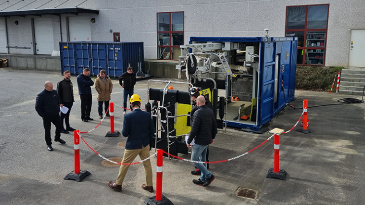
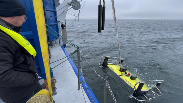
A containerised remotely operated towed vehicle (ROTV) solution, developed for the UK Ministry of Defence (MoD), has successfully completed Factory Acceptance Tests (FAT).

The comes just 6 months after the contract was awarded to Danish subsea engineering specialist EIVA. 

Through containerisation, this new type of survey solution enables hydrographic surveys with multiple acoustic survey sensors and instruments to be performed from many different host platforms with very short deployment time.

Christian Thomsen, CEO of EIVA, said; “The agility with which this total solution has been developed showcases that by combining our efforts with several strong players in the market, we can leverage our many years of experience. Together, we make way for new possibilities in defence and other maritime markets.”

The components of this survey solution include SH Group’s 20’ Cube container module and launch and recovery system for EIVA’s ScanFish L ROTV, which is equipped with Sonardyne’s SPRINT-Nav Mini hybrid INS/DVL and Voyis’ Observer Pro optical camera and Insight Pro laser scanner. Two dedicated computer workstations are built into the container and equipped with EIVA’s NaviSuite software for efficiently processing and analysing the collected data.

Factory acceptance test of the containerised ROTV solution at EIVA HQ.

Lieutenant Commander Mark Butcher, Royal Navy, added; “After visiting EIVA headquarters for the FAT, we were extremely happy with the system developed. The EIVA team have worked hard to deliver a capability that will expand the survey capability of our ships, enhancing survey operations and features within our Future Military Data Gathering programme. We look forward to the next steps including commission testing and training with the Royal Navy’s specialist Hydrographic teams.”

Posted by Joe Macey Joseph Macey is a Content Specialist at Ocean Science & Technology, where he has focused on emerging marine technologies since joining in 2022. He brings particular expertise in autopilot systems, AUVs, and subsea imaging. A graduate of Falmouth University in Journalism, Joseph began his career in 2019 as a local reporter. His background in journalism not only hones his reporting skills but also strengthens his ability to conduct in-depth interviews, allowing him to provide authoritative insights on the latest industry trends. Connect

Latest Articles

Profile Spotlight: IQUA Robotics for Autonomous Underwater Survey & Inspection

IQUA Robotics is presenting its hovering AUV technologies on OST, providing precise, maneuverable platforms for subsea mapping, inspection, and reconnaissance

Nov 20, 2025
Precision Terrain Modeling & Hydrological Analysis with Global Mapper

Blue Marble Geographics’ Global Mapper enables Egis to streamline digital terrain modeling and hydrological analysis, enhancing data processing efficiency across large-scale environmental projects

Nov 20, 2025
Real-Time Vibration Analysis Embedded in SBG Systems IMU

SBG Systems’ IMU now features built-in vibration monitoring, delivering real-time analysis to enhance accuracy, detect resonance, and support design, testing, and structural monitoring

Nov 19, 2025
Kraken Robotics Forms Reseller Partnership to Expand Access to Subsea Sonar Technology

Kraken Robotics has appointed BlueZone Group as an authorized reseller of its SAS and KATFISH platform, offering high-resolution underwater imaging, bathymetric mapping, and rapid data collection for defense and commercial surveys in Australia and New Zealand

Nov 19, 2025
Monitoring Marine Environments with Pro-Oceanus Dissolved Gas Sensors

Discover how Pro-Oceanus Systems’ advanced sensors help explore the oceans, measure dissolved gases, and uncover critical insights into marine and climate processes

Nov 18, 2025
Strategic Partnership to Deliver High-Resolution Deep-Sea Seafloor Intelligence & Insights

PlanBlue and Orpheus Ocean have collaborated to integrate advanced AI-driven imaging with autonomous underwater vehicles, enabling enhanced monitoring and analysis of critical deep-sea environments

Nov 17, 2025

Featured Content

FarSounder Integration Delivers Real-Time Seafloor & Obstacle Detection to SYNAPSIS Users

FarSounder has integrated its Argos 3D Forward Looking Sonar with Anschütz’s SYNAPSIS navigation platform, bringing real-time subsurface insights directly into the (W)ECDIS NX interface

Nov 17, 2025
Boxfish ROV Captures Marine Research Footage for Upcoming Premiere

Scientists from the University of Tasmania used a custom Boxfish ROV to survey Beagle Marine Park, capturing underwater footage premiering on YouTube this November

Nov 12, 2025
SubC Imaging Observatory Camera Systems Support Long-Term Ocean Observation

SubC Imaging’s Observatory Camera Systems capture detailed subsea imagery for cabled ocean observatories, enabling continuous observation and long-term marine environmental studies

Nov 11, 2025