Collaboration to Streamline Hydrographic Surveys with Real-Time Data Processing

Surveyors can now run Hypack's hydrographic survey software directly in the cloud through Terradepth's Absolute Ocean platform, enabling near real-time processing of ocean data By William Mackenzie / 22 Jul 2024

Discover World-Leading Technologies for Ocean Science

Discover cutting-edge solutions from leading global suppliers
SUPPLIER SPOTLIGHT
Collaboration to Streamline Hydrographic Surveys with Real-Time Data Processing
Follow OS&T

Ocean data as a service company Terradepth is working with Hypack to streamline the hydrographic survey workflow, addressing a key challenge in the industry. 

As part of the collaboration, Hypack’s hydrographic survey software will be integrated with Terradepth’s cloud-native Absolute Ocean platform. With this, Hydrographic surveyors can now process ocean data in near-real time during surveys and seamlessly contextualize it with existing geophysical data. 

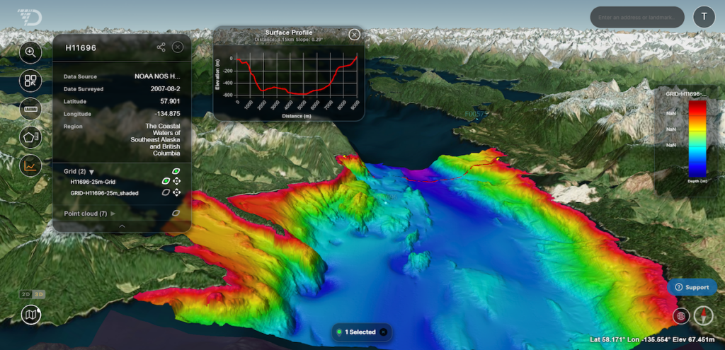
This integration is set to reduce the time from data collection to actionable insights, and shrink lead times from weeks to hours.

Surveyors typically process data locally on laptops and face significant hurdles in receiving the data in a timely manner, and then sharing that data with end users when processed. This leads to surveyors often relying on slow and inefficient methods such as file hosting services or physical hard drive shipments.

The partnership offers faster decision making with near real-time access to survey data for all end users, as well as flexible team structures enabled by location-independent data processing. 

The collaboration provides scalable processing power that eliminates the need for expensive onboard hardware, and delivers enhanced data security by avoiding physical data transfers and unsecured file hosting platforms. 

Joe Wolfel, CEO of Terradepth, commented; “We are very excited to share our latest innovation in ocean data processing with the integration of Absolute Ocean and HYPACK’s sonar data software. Our goal is to revolutionize the hydrographic industry, making ocean data more accessible, efficient, and actionable than ever before, and this partnership is a great example of this.”

Straud Armstrong, Director of Business Development at HYPACK, added; “We are excited to collaborate with Terradepth in offering an industry first: a complete, end-to-end subsea geophysical data processing, management, and delivery solution with HYPACK and Absolute Ocean, running in the cloud. 

“This partnership will provide our customers a dramatic efficiency gain from data collection to delivery, while enabling a secure processing from anywhere approach, and an easy way to ramp-up/ramp-down environments.” 

Posted by William Mackenzie Will is a Content Specialist at Ocean Science Technology. Joining in 2024 with a background in professional copywriting and creative content, Will brings expertise in oceanographic monitoring, aquaculture, and environmental analysis. He provides in-depth coverage of breakthroughs in marine research, subsea systems, and autonomous platforms, drawing on his specialist understanding of ocean technology to highlight innovations shaping the future of the marine industry. Connect

Latest Articles

Profile Spotlight: IQUA Robotics for Autonomous Underwater Survey & Inspection

IQUA Robotics is presenting its hovering AUV technologies on OST, providing precise, maneuverable platforms for subsea mapping, inspection, and reconnaissance

Nov 20, 2025
Precision Terrain Modeling & Hydrological Analysis with Global Mapper

Blue Marble Geographics’ Global Mapper enables Egis to streamline digital terrain modeling and hydrological analysis, enhancing data processing efficiency across large-scale environmental projects

Nov 20, 2025
Real-Time Vibration Analysis Embedded in SBG Systems IMU

SBG Systems’ IMU now features built-in vibration monitoring, delivering real-time analysis to enhance accuracy, detect resonance, and support design, testing, and structural monitoring

Nov 19, 2025
Kraken Robotics Forms Reseller Partnership to Expand Access to Subsea Sonar Technology

Kraken Robotics has appointed BlueZone Group as an authorized reseller of its SAS and KATFISH platform, offering high-resolution underwater imaging, bathymetric mapping, and rapid data collection for defense and commercial surveys in Australia and New Zealand

Nov 19, 2025
Monitoring Marine Environments with Pro-Oceanus Dissolved Gas Sensors

Discover how Pro-Oceanus Systems’ advanced sensors help explore the oceans, measure dissolved gases, and uncover critical insights into marine and climate processes

Nov 18, 2025
Strategic Partnership to Deliver High-Resolution Deep-Sea Seafloor Intelligence & Insights

PlanBlue and Orpheus Ocean have collaborated to integrate advanced AI-driven imaging with autonomous underwater vehicles, enabling enhanced monitoring and analysis of critical deep-sea environments

Nov 17, 2025

Featured Content

FarSounder Integration Delivers Real-Time Seafloor & Obstacle Detection to SYNAPSIS Users

FarSounder has integrated its Argos 3D Forward Looking Sonar with Anschütz’s SYNAPSIS navigation platform, bringing real-time subsurface insights directly into the (W)ECDIS NX interface

Nov 17, 2025
Boxfish ROV Captures Marine Research Footage for Upcoming Premiere

Scientists from the University of Tasmania used a custom Boxfish ROV to survey Beagle Marine Park, capturing underwater footage premiering on YouTube this November

Nov 12, 2025
SubC Imaging Observatory Camera Systems Support Long-Term Ocean Observation

SubC Imaging’s Observatory Camera Systems capture detailed subsea imagery for cabled ocean observatories, enabling continuous observation and long-term marine environmental studies

Nov 11, 2025