ANELLO Introduces INS for Maritime Applications

The ANELLO Maritime Inertial Navigation System (INS), launched at CES 2025 in Las Vegas, features a compact and lightweight design, an IP68 waterproof rating, and resilience in heavy shock environments By Joe Macey / 14 Jan 2025

Inertial Navigation Systems (INS)

Discover cutting-edge solutions from 5 leading global suppliers
SUPPLIER SPOTLIGHT
Maritime INS from ANELLO Photonics.
Follow OS&T

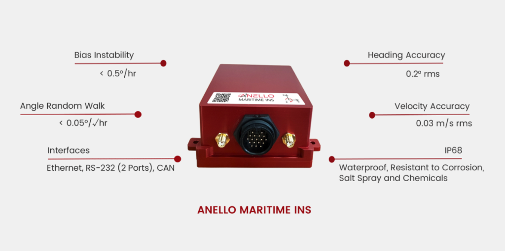
Creator of the Silicon Photonic Optical Gyroscope (SiPhOG) and developer of inertial navigation systems (INS), ANELLO Photonics, has launched the ANELLO Maritime Inertial Navigation System (INS).

The product is seen as a significant advancement in navigation technology for marine applications in GPS-denied or spoofed environments.

The ANELLO Maritime INS integrates the company’s SiPhOG™ technology with its advanced sensor fusion engine to deliver unparalleled precision and reliability for autonomous surface vessels (ASVs) and autonomous underwater vessels (AUVs).

The design of the ANELLO Maritime INS combines the high-performance capabilities of optical gyroscopes with the compact form factor and low power consumption of silicon photonics. This results in a versatile Inertial Reference System (IRS) that delivers exceptional performance in GPS-challenged maritime environments.

Dr. Mario Paniccia, CEO of ANELLO Photonics, said, “The launch of the ANELLO Maritime INS signifies a pivotal advancement in our mission to transform navigation, enhancing precision and reliability for autonomous vessels operating in GPS-denied or spoofed environments.

“Our technology has been rigorously field-tested across land, air, and now in sea environments. We are excited to offer a navigation solution for autonomous systems in challenging maritime environments.”

Mike Flanigan, CEO of Seasats, commented, “Integrating the ANELLO technology into our autonomous surface vessels has significantly enhanced our navigation capabilities in GPS-denied scenarios. This technology is a game-changer for maritime operations, enabling safer and more efficient autonomous missions at sea.” 

This launch is said to reinforce ANELLO’s commitment to providing comprehensive solutions for GPS-denied navigation across various domains. By expanding its portfolio to now include maritime applications, ANELLO Photonics states that it is continuing to demonstrate its leadership in developing next-generation navigation technologies for autonomous systems across land, air, and sea environments.

Posted by Joe Macey Joseph Macey is a Content Specialist at Ocean Science & Technology, where he has focused on emerging marine technologies since joining in 2022. He brings particular expertise in autopilot systems, AUVs, and subsea imaging. A graduate of Falmouth University in Journalism, Joseph began his career in 2019 as a local reporter. His background in journalism not only hones his reporting skills but also strengthens his ability to conduct in-depth interviews, allowing him to provide authoritative insights on the latest industry trends. Connect

Latest Articles

Precision Terrain Modeling & Hydrological Analysis with Global Mapper

Blue Marble Geographics’ Global Mapper enables Egis to streamline digital terrain modeling and hydrological analysis, enhancing data processing efficiency across large-scale environmental projects

Nov 20, 2025
Real-Time Vibration Analysis Embedded in SBG Systems IMU

SBG Systems’ IMU now features built-in vibration monitoring, delivering real-time analysis to enhance accuracy, detect resonance, and support design, testing, and structural monitoring

Nov 19, 2025
Kraken Robotics Forms Reseller Partnership to Expand Access to Subsea Sonar Technology

Kraken Robotics has appointed BlueZone Group as an authorized reseller of its SAS and KATFISH platform, offering high-resolution underwater imaging, bathymetric mapping, and rapid data collection for defense and commercial surveys in Australia and New Zealand

Nov 19, 2025
Monitoring Marine Environments with Pro-Oceanus Dissolved Gas Sensors

Discover how Pro-Oceanus Systems’ advanced sensors help explore the oceans, measure dissolved gases, and uncover critical insights into marine and climate processes

Nov 18, 2025
Strategic Partnership to Deliver High-Resolution Deep-Sea Seafloor Intelligence & Insights

PlanBlue and Orpheus Ocean have collaborated to integrate advanced AI-driven imaging with autonomous underwater vehicles, enabling enhanced monitoring and analysis of critical deep-sea environments

Nov 17, 2025
FarSounder Integration Delivers Real-Time Seafloor & Obstacle Detection to SYNAPSIS Users

FarSounder has integrated its Argos 3D Forward Looking Sonar with Anschütz’s SYNAPSIS navigation platform, bringing real-time subsurface insights directly into the (W)ECDIS NX interface

Nov 17, 2025

Featured Content

FarSounder Integration Delivers Real-Time Seafloor & Obstacle Detection to SYNAPSIS Users

FarSounder has integrated its Argos 3D Forward Looking Sonar with Anschütz’s SYNAPSIS navigation platform, bringing real-time subsurface insights directly into the (W)ECDIS NX interface

Nov 17, 2025
Boxfish ROV Captures Marine Research Footage for Upcoming Premiere

Scientists from the University of Tasmania used a custom Boxfish ROV to survey Beagle Marine Park, capturing underwater footage premiering on YouTube this November

Nov 12, 2025
SubC Imaging Observatory Camera Systems Support Long-Term Ocean Observation

SubC Imaging’s Observatory Camera Systems capture detailed subsea imagery for cabled ocean observatories, enabling continuous observation and long-term marine environmental studies

Nov 11, 2025