Radar for Offshore Wind Energy Research Deployed

DeTect’s MERLIN True3D radar system for offshore vessel and buoy deployments is part of an initiative to gather weather, ocean, and wildlife data near the sites of active offshore wind farms By Abi Wylie / 01 Jul 2024

Connect with Leading Marine Technology Innovators

Discover cutting-edge solutions from leading global suppliers
SUPPLIER SPOTLIGHT
Radar for Offshore Wind Energy Research Deployed
Follow OS&T

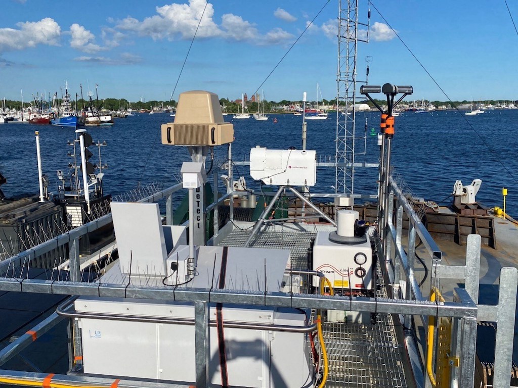
DeTect Inc. is part of a collaboration whose efforts include an 18-month initiative to gather extensive weather, ocean, and wildlife data near the sites of active offshore wind farms and lease areas off the coast of the northeast United States. 

DeTect Inc’s involvement includes the MERLIN True3D radar system specifically designed for offshore vessel and buoy deployments. The radar system is designed to handle the complexities of collecting avian and bat movements while compensating for the dynamics of being on a moving platform. 

The radar system is coupled with an electronic stabilization system that is designed for the dynamics of the ocean environment correcting the collected track data in real-time data to compensate for heading, roll, pitch, and yaw. It is a full 360 degree system with track updates of 4 timers per second. 

The system collects critical information on the positional and altitudinal information of airborne targets which permits the radar system to collect valuable data on the bird/bat flux rates as well as wildlife movement patterns and associated altitudes.

Involved are DeTect, the U.S. Department of Energy (DOE), the National Oceanic and Atmospheric Administration (NOAA), Woods Hole Oceanographic Institution (WHOI), and Pacific Northwest National Laboratory (PNNL). 

This effort is part of the third phase of the Wind Forecast Improvement Project (WFIP3), which will obtain extensive met-ocean-environmental observations onboard an autonomous moored barge to improve the design and operation of offshore wind turbines and wind farms. 

DeTect’s proven technology can be integrated with radar-directed electro-optic, infrared (EOIR) camera system. The system comes in a fixed or mobile design, fully self-contained with all system hardware, software and integration included.

Posted by Abi Wylie Edited by Abigail Wylie, Editor and Copywriter experienced in digital media with a keen interest in ocean science technology. Connect & Contact

Latest Articles

Advanced Multibeam Sonar Technology Expands Capabilities in Offshore & Energy Sectors

Oceanscan Singapore expands its global rental fleet with the latest NORBIT multibeam sonar systems, enhancing survey capabilities for energy and offshore markets

May 01, 2025
AGISTAR Unveils Compact Remote-Controlled Motor for Inflatable Boats

AGISTAR has unveiled the OXR-T100, a compact, remote-controlled electric motor engineered for inflatable boats, delivering quiet, eco-friendly performance across demanding marine environments

May 01, 2025
AXYS Technologies MetOcean Observation Networks

AXYS Technologies supplies high-precision MetOcean data solutions that support marine safety, scientific research, environmental monitoring, and policy development across more than 80 countries

Apr 30, 2025
MostaTech to Launch Advanced Gyroscopes at XPONENTIAL 2025

MostaTech will present advanced fiber optic gyroscopes and inertial measurement units at XPONENTIAL 2025, highlighting advancements in low-SWaP, high-performance navigation technology

Apr 30, 2025
D-2 Ultra Low Power CTD Integrated into WHOI Arctic Research

D-2 Inc.’s advanced CTD sensor supports WHOI’s Arctic climate research, enhancing data precision in the Ice Tethered Profiler program’s latest deployments

Apr 30, 2025
Kraken Robotics Secures $11 Million in New Battery Orders

Kraken Robotics has received new orders for its SeaPower™ batteries, powering advanced uncrewed underwater vehicles (UUVs) and driving growth in the defense sector

Apr 29, 2025

Featured Content

D-2 Ultra Low Power CTD Integrated into WHOI Arctic Research

D-2 Inc.’s advanced CTD sensor supports WHOI’s Arctic climate research, enhancing data precision in the Ice Tethered Profiler program’s latest deployments

Apr 30, 2025
Case Study: Impact Subsea Altimeter Supports Antarctic Science

Impact Subsea's ISA500 underwater altimeter plays a key role in the Icefin AUV as it collects vital data, passing through narrow boreholes drilled into Antarctic ice shelves

Apr 23, 2025
Kongsberg Discovery Supplies Technology to Convert Sailing Ship into Research Vessel

Kongsberg Discovery has upgraded the Statsraad Lehmkuhl for the One Ocean Expedition, providing advanced systems to support climate and ecosystem research

Apr 17, 2025