New Shallow Water Dynamic Positioning Technology Launched

Sonardyne has released its new shallow water DP reference system, SPRINT-Nav DP, integrating high-grade inertial navigation with DVL technology in a single, pre-calibrated unit By Abi Wylie / 09 Apr 2025

Underwater Acoustic Positioning Systems

Discover cutting-edge solutions from 7 leading global suppliers
SUPPLIER SPOTLIGHT
New Shallow Water Dynamic Positioning Technology Launched
Follow OS&T

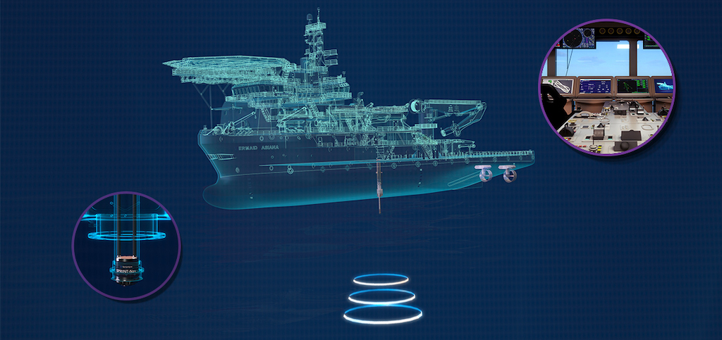
Building on Sonardyne’s decade-long expertise in hybrid acoustic-inertial navigation systems, the company has launched of its new shallow water dynamic positioning (DP) reference system.

SPRINT-Nav DP integrates high-grade inertial navigation with doppler velocity log (DVL) technology in a single, pre-calibrated unit. The system joins Sonardyne’s renowned SPRINT-Nav family, which has become the standard for underwater vehicle navigation worldwide.

Developed in response to SPRINT-Nav customer’s requests and an increasing demand for shallow water DP operations from the offshore wind farm sector, SPRINT-Nav DP has undergone extensive trials and validation tests to ensure it maintains the mandatory class requirements as an alternative position reference into a vessel’s DP system.

SPRINT-Nav DP provides accurate and reliable positioning without the need for a GNSS signal. This makes it ideal for a wide range of shallow water operations, including offshore renewable energy and nearshore work where GNSS signals are often spoofed, blocked or distorted by nearby structures.

This latest addition to the SPRINT-Nav family also saves DP vessel operators both time and money. The DVL bottom-lock technology, effective up to 230 m depth, means there is no need to deploy sensors or other equipment as the seabed itself is used as the positioning reference. Factory pre-calibration means that SPRINT-Nav DP is operational as soon as the vessel arrives on site.

Duncan Rigg, Business Development Manager – Vessel Systems, commented, “SPRINT-Nav DP represents a leap forward in shallow water vessel positioning. By removing GNSS dependencies, we’re enabling operators to work more efficiently and dependably in challenging environments.

“Many existing customers had asked about using their SPRINT-Nav’s for dynamic positioning and we are delighted to introduce SPRINT-Nav DP to enhance their operations.”

Posted by Abi Wylie Edited by Abigail Wylie, Editor and Copywriter experienced in digital media with a keen interest in ocean science technology. Connect & Contact

Latest Articles

AXYS Technologies MetOcean Observation Networks

AXYS Technologies supplies high-precision MetOcean data solutions that support marine safety, scientific research, environmental monitoring, and policy development across more than 80 countries

Apr 30, 2025
MostaTech to Launch Advanced Gyroscopes at XPONENTIAL 2025

MostaTech will present advanced fiber optic gyroscopes and inertial measurement units at XPONENTIAL 2025, highlighting advancements in low-SWaP, high-performance navigation technology

Apr 30, 2025
D-2 Ultra Low Power CTD Integrated into WHOI Arctic Research

D-2 Inc.’s advanced CTD sensor supports WHOI’s Arctic climate research, enhancing data precision in the Ice Tethered Profiler program’s latest deployments

Apr 30, 2025
Kraken Robotics Secures $11 Million in New Battery Orders

Kraken Robotics has received new orders for its SeaPower™ batteries, powering advanced uncrewed underwater vehicles (UUVs) and driving growth in the defense sector

Apr 29, 2025
SubC Imaging Enhances Data Storage Flexibility with Rayfin Software Update

SubC Imaging has released a new software update, designed to provide enhanced flexibility to the Rayfin camera family

Apr 28, 2025
MERLIN Radar Deployed Offshore for Bird Migration Monitoring

Ocergy and DeTect have deployed advanced radar technology offshore to monitor bird migration, supporting environmental assessments and expanding knowledge of avian movement patterns

Apr 28, 2025

Featured Content

D-2 Ultra Low Power CTD Integrated into WHOI Arctic Research

D-2 Inc.’s advanced CTD sensor supports WHOI’s Arctic climate research, enhancing data precision in the Ice Tethered Profiler program’s latest deployments

Apr 30, 2025
Case Study: Impact Subsea Altimeter Supports Antarctic Science

Impact Subsea's ISA500 underwater altimeter plays a key role in the Icefin AUV as it collects vital data, passing through narrow boreholes drilled into Antarctic ice shelves

Apr 23, 2025
Kongsberg Discovery Supplies Technology to Convert Sailing Ship into Research Vessel

Kongsberg Discovery has upgraded the Statsraad Lehmkuhl for the One Ocean Expedition, providing advanced systems to support climate and ecosystem research

Apr 17, 2025