New Marine Data Platform to Debut at Ocean Business 2025

Tritonia is set to unveil Hydrophis at Ocean Business, a next-generation marine data platform that revolutionizes underwater surveying with AI-powered insights, 3D photogrammetry, and seamless data integration By Joe Macey / 04 Apr 2025

Discover World-Leading Technologies for Ocean Science

Discover cutting-edge solutions from leading global suppliers
SUPPLIER SPOTLIGHT
New Marine Data Platform to Debut at Ocean Business 2025
Follow OS&T

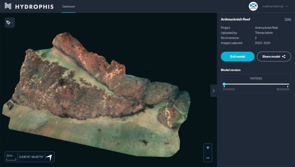
Tritonia is set to unveil Hydrophis, an advanced marine data platform, at Ocean Business 2025, on April 8.

Designed to enhance how organizations host, visualize, and analyze underwater survey data, Hydrophis brings a new level of clarity to seabed assessments and underwater asset inspections.

Hydrophis redefines marine surveying by seamlessly integrating multiple data types, including georeferenced 3D photogrammetry, AI-driven analysis, side-scan sonar, orthomosaics, and multibeam sonar data. This powerful combination provides users with an unparalleled view of the underwater world. Whether assessing seabed characteristics, inspecting offshore structures, monitoring environmental changes, or ensuring regulatory compliance, Hydrophis enables professionals to make faster, more informed decisions with unmatched precision.

Hydrophis Key Features & Benefits

  • Seamless Seabed Visualization: View high-resolution, georeferenced 3D photogrammetry for accurate underwater assessments.
  • Data Centralization: Integrate, analyze, and display all marine data within a single, customizable platform.
  • AI-Powered Insights: Automate species and object identification to enhance efficiency and improve decision-making.
  • Time-Based Change Detection: Compare photogrammetry models over time to detect seabed changes and assess infrastructure integrity instantly.
  • Collaborative & Customizable: Easily share data with teams, clients, and regulators while tailoring the platform to meet specific organizational needs.

Martin Sayer, Managing Director of Tritonia Scientific, said, “We developed Hydrophis to bridge the gap between data collection and clear insights, helping users focus on what’s important to them. By combining 3D photogrammetry, AI, and geospatial intelligence, Hydrophis empowers organisations to make faster, more informed decisions—whether for research, commercial applications, or environmental protection.”

By bringing together next-generation technology and intelligent automation, Hydrophis is seen to transform marine data management—delivering impressive accuracy, efficiency, and insight to the offshore industry.

Posted by Joe Macey Joseph Macey is a Content Specialist at Ocean Science & Technology, where he has focused on emerging marine technologies since joining in 2022. He brings particular expertise in autopilot systems, AUVs, and subsea imaging. A graduate of Falmouth University in Journalism, Joseph began his career in 2019 as a local reporter. His background in journalism not only hones his reporting skills but also strengthens his ability to conduct in-depth interviews, allowing him to provide authoritative insights on the latest industry trends. Connect

Latest Articles

Real-Time Vibration Analysis Embedded in SBG Systems IMU

SBG Systems’ IMU now features built-in vibration monitoring, delivering real-time analysis to enhance accuracy, detect resonance, and support design, testing, and structural monitoring

Nov 19, 2025
Kraken Robotics Forms Reseller Partnership to Expand Access to Subsea Sonar Technology

Kraken Robotics has appointed BlueZone Group as an authorized reseller of its SAS and KATFISH platform, offering high-resolution underwater imaging, bathymetric mapping, and rapid data collection for defense and commercial surveys in Australia and New Zealand

Nov 19, 2025
Monitoring Marine Environments with Pro-Oceanus Dissolved Gas Sensors

Discover how Pro-Oceanus Systems’ advanced sensors help explore the oceans, measure dissolved gases, and uncover critical insights into marine and climate processes

Nov 18, 2025
Strategic Partnership to Deliver High-Resolution Deep-Sea Seafloor Intelligence & Insights

PlanBlue and Orpheus Ocean have collaborated to integrate advanced AI-driven imaging with autonomous underwater vehicles, enabling enhanced monitoring and analysis of critical deep-sea environments

Nov 17, 2025
FarSounder Integration Delivers Real-Time Seafloor & Obstacle Detection to SYNAPSIS Users

FarSounder has integrated its Argos 3D Forward Looking Sonar with Anschütz’s SYNAPSIS navigation platform, bringing real-time subsurface insights directly into the (W)ECDIS NX interface

Nov 17, 2025
Underwater Optical Communication Showcases 5.2 Gbps Transmission for Marine Applications

Kyocera has demonstrated a high-speed Underwater Wireless Optical Communication (UWOC) technology capable of transmitting data at 5.2 Gbps, enabling real-time, large-volume data exchange for underwater vehicles and ocean exploration

Nov 14, 2025

Featured Content

FarSounder Integration Delivers Real-Time Seafloor & Obstacle Detection to SYNAPSIS Users

FarSounder has integrated its Argos 3D Forward Looking Sonar with Anschütz’s SYNAPSIS navigation platform, bringing real-time subsurface insights directly into the (W)ECDIS NX interface

Nov 17, 2025
Boxfish ROV Captures Marine Research Footage for Upcoming Premiere

Scientists from the University of Tasmania used a custom Boxfish ROV to survey Beagle Marine Park, capturing underwater footage premiering on YouTube this November

Nov 12, 2025
SubC Imaging Observatory Camera Systems Support Long-Term Ocean Observation

SubC Imaging’s Observatory Camera Systems capture detailed subsea imagery for cabled ocean observatories, enabling continuous observation and long-term marine environmental studies

Nov 11, 2025