Fully Integrated Multibeam Echosounder Launched with Built-in Sonar Processor, IMU, GNSS and SVS

Hydro-Tech introduces the MS400C, the industry’s first fully integrated multibeam echo sounder, combining sonar, IMU, GNSS, and SVS for streamlined, high-efficiency USV deployment By Joe Macey / 03 Apr 2025

Multibeam Echosounders

Discover cutting-edge solutions from 10 leading global suppliers
SUPPLIER SPOTLIGHT
Fully Integrated Multibeam Echosounder Launched with Built-in Sonar Processor, IMU, GNSS and SVS
Follow OS&T

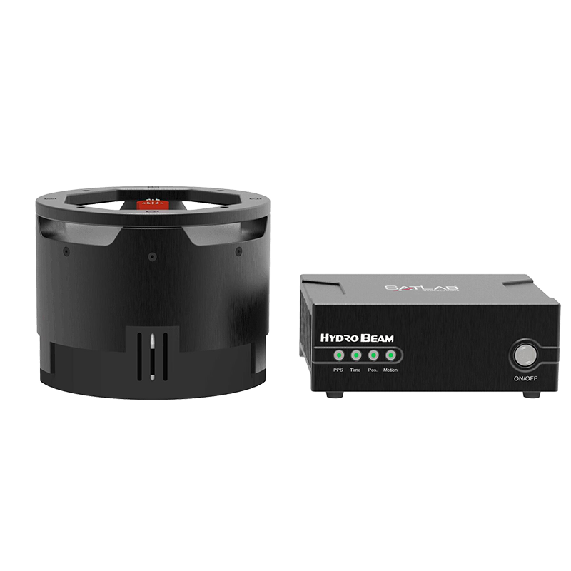
Hydro-Tech has launched the MS400C, the first fully integrated multibeam echosounder of its kind.

Designed to streamline operations and enhance efficiency, the MS400C consolidates a sonar processor, Inertial Measurement Unit (IMU), Global Navigation Satellite System (GNSS), and Sound Velocity Sensor (SVS) into a single, compact sonar head. This innovative design transforms multibeam deployment, particularly for small Unmanned Surface Vehicles (USVs), reducing complexity and improving operational flexibility.

The MS400C eliminates the need for a separate sonar processor, simplifying installation and reducing potential points of failure. Deployment is straightforward: mount the sonar head to the Unmanned Surface Vehicle, connect the power and data cables, and link the GNSS antennas. This integrated approach minimizes installation errors, shortens setup time, and reduces the need for extensive operator training. Additionally, its compact design optimizes space within the USV’s waterproof compartment.

Traditional multibeam systems often struggle with overheating, especially in harsh environments. The MS400C overcomes this challenge by housing all critical components—including the sonar processor and IMU—within the sonar head, which is continuously cooled by surrounding water. This eliminates exposure to direct sunlight and ensures stable, long-term performance, even in extreme heat conditions.

The MS400C is engineered for effortless deployment. All positional relationships between the IMU, transducer, and GNSS antenna are preconfigured in the software by the USV manufacturer. Once in the field, operators can complete setup within minutes and initiate surveys using the Auto Survey function. The system intelligently adjusts working parameters based on environmental conditions, removing the need for manual calibration and significantly boosting efficiency.

With integrated real-time roll stabilization, precise vessel attitude measurements, and accurate sound velocity corrections, the MS400C delivers high-resolution depth data with exceptional reliability. Its lightweight yet powerful design makes it an ideal solution for inland hydrographic surveys and demanding bathymetric applications.

Posted by Joe Macey Connect & Contact

Latest Articles

AXYS Technologies MetOcean Observation Networks

AXYS Technologies supplies high-precision MetOcean data solutions that support marine safety, scientific research, environmental monitoring, and policy development across more than 80 countries

Apr 30, 2025
MostaTech to Launch Advanced Gyroscopes at XPONENTIAL 2025

MostaTech will present advanced fiber optic gyroscopes and inertial measurement units at XPONENTIAL 2025, highlighting advancements in low-SWaP, high-performance navigation technology

Apr 30, 2025
D-2 Ultra Low Power CTD Integrated into WHOI Arctic Research

D-2 Inc.’s advanced CTD sensor supports WHOI’s Arctic climate research, enhancing data precision in the Ice Tethered Profiler program’s latest deployments

Apr 30, 2025
Kraken Robotics Secures $11 Million in New Battery Orders

Kraken Robotics has received new orders for its SeaPower™ batteries, powering advanced uncrewed underwater vehicles (UUVs) and driving growth in the defense sector

Apr 29, 2025
SubC Imaging Enhances Data Storage Flexibility with Rayfin Software Update

SubC Imaging has released a new software update, designed to provide enhanced flexibility to the Rayfin camera family

Apr 28, 2025
MERLIN Radar Deployed Offshore for Bird Migration Monitoring

Ocergy and DeTect have deployed advanced radar technology offshore to monitor bird migration, supporting environmental assessments and expanding knowledge of avian movement patterns

Apr 28, 2025

Featured Content

D-2 Ultra Low Power CTD Integrated into WHOI Arctic Research

D-2 Inc.’s advanced CTD sensor supports WHOI’s Arctic climate research, enhancing data precision in the Ice Tethered Profiler program’s latest deployments

Apr 30, 2025
Case Study: Impact Subsea Altimeter Supports Antarctic Science

Impact Subsea's ISA500 underwater altimeter plays a key role in the Icefin AUV as it collects vital data, passing through narrow boreholes drilled into Antarctic ice shelves

Apr 23, 2025
Kongsberg Discovery Supplies Technology to Convert Sailing Ship into Research Vessel

Kongsberg Discovery has upgraded the Statsraad Lehmkuhl for the One Ocean Expedition, providing advanced systems to support climate and ecosystem research

Apr 17, 2025