Fugro Expands Seafloor Mapping Efforts to Strengthen Florida’s Coastline

Fugro is expanding its role in Florida’s largest seafloor mapping initiative, gathering critical data to enhance coastal resilience, infrastructure planning, and environmental protection across the state By Joe Macey / 06 Feb 2025

Discover World-Leading Technologies for Ocean Science

Discover cutting-edge solutions from leading global suppliers
SUPPLIER SPOTLIGHT
Fugro Expands Seafloor Mapping Efforts to Strengthen Florida’s Coastline
Follow OS&T

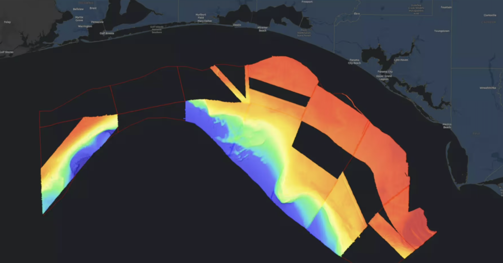
Fugro is expanding its involvement in the Florida Seafloor Mapping Initiative (FSMI), a long-term project led by the Florida Department of Environmental Protection (DEP) to survey the state’s underwater terrain.

The initiative aims to enhance coastal resilience, guide infrastructure development, and support environmental conservation efforts.

After previously securing a contract to capture 14,000 square kilometres of airborne lidar data for FSMI, Fugro has now launched vessel-based mapping across a vast 42,000-square-kilometre area offshore Florida.

This extensive new survey spans five of the six Florida DEP project regions, covering the full Atlantic coastline, the Florida Keys, and sections of the Gulf Coast. Originally initiated in late 2024 with a single research vessel, operations have rapidly scaled into a multi-ship mission. Fieldwork is coordinated through Fugro’s advanced VirGeo® system, ensuring real-time oversight and seamless collaboration with Florida DEP.

The destructive 2024 hurricane season underscored the urgent need for forward-thinking coastal management in Florida. Through strategic partnerships with organizations like Fugro, FSMI is acquiring critical data to help the state adapt to shifting shorelines and protect both communities and industries.

Mark MacDonald, Director of Hydrography for Fugro in the Americas, said, “We’re proud to contribute to the FSMI, an investment in Florida’s future and a programme that sets an example for other coastal regions.

“The programme’s fit-for-purpose data collection, deployed at scale, directly supports more effective coastal adaptation and mitigation strategies, maximising benefits to the state.”

Fugro is handling 65% of FSMI’s vessel-based survey work, highlighting its technical expertise and dedication to strengthening coastal resilience. Data collection is scheduled to wrap up in late 2025, with final results expected in 2026.

Posted by Joe Macey Joseph Macey is a Content Specialist at Ocean Science & Technology, where he has focused on emerging marine technologies since joining in 2022. He brings particular expertise in autopilot systems, AUVs, and subsea imaging. A graduate of Falmouth University in Journalism, Joseph began his career in 2019 as a local reporter. His background in journalism not only hones his reporting skills but also strengthens his ability to conduct in-depth interviews, allowing him to provide authoritative insights on the latest industry trends. Connect

Latest Articles

Real-Time Vibration Analysis Embedded in SBG Systems IMU

SBG Systems’ IMU now features built-in vibration monitoring, delivering real-time analysis to enhance accuracy, detect resonance, and support design, testing, and structural monitoring

Nov 19, 2025
Kraken Robotics Forms Reseller Partnership to Expand Access to Subsea Sonar Technology

Kraken Robotics has appointed BlueZone Group as an authorized reseller of its SAS and KATFISH platform, offering high-resolution underwater imaging, bathymetric mapping, and rapid data collection for defense and commercial surveys in Australia and New Zealand

Nov 19, 2025
Monitoring Marine Environments with Pro-Oceanus Dissolved Gas Sensors

Discover how Pro-Oceanus Systems’ advanced sensors help explore the oceans, measure dissolved gases, and uncover critical insights into marine and climate processes

Nov 18, 2025
Strategic Partnership to Deliver High-Resolution Deep-Sea Seafloor Intelligence & Insights

PlanBlue and Orpheus Ocean have collaborated to integrate advanced AI-driven imaging with autonomous underwater vehicles, enabling enhanced monitoring and analysis of critical deep-sea environments

Nov 17, 2025
FarSounder Integration Delivers Real-Time Seafloor & Obstacle Detection to SYNAPSIS Users

FarSounder has integrated its Argos 3D Forward Looking Sonar with Anschütz’s SYNAPSIS navigation platform, bringing real-time subsurface insights directly into the (W)ECDIS NX interface

Nov 17, 2025
Underwater Optical Communication Showcases 5.2 Gbps Transmission for Marine Applications

Kyocera has demonstrated a high-speed Underwater Wireless Optical Communication (UWOC) technology capable of transmitting data at 5.2 Gbps, enabling real-time, large-volume data exchange for underwater vehicles and ocean exploration

Nov 14, 2025

Featured Content

FarSounder Integration Delivers Real-Time Seafloor & Obstacle Detection to SYNAPSIS Users

FarSounder has integrated its Argos 3D Forward Looking Sonar with Anschütz’s SYNAPSIS navigation platform, bringing real-time subsurface insights directly into the (W)ECDIS NX interface

Nov 17, 2025
Boxfish ROV Captures Marine Research Footage for Upcoming Premiere

Scientists from the University of Tasmania used a custom Boxfish ROV to survey Beagle Marine Park, capturing underwater footage premiering on YouTube this November

Nov 12, 2025
SubC Imaging Observatory Camera Systems Support Long-Term Ocean Observation

SubC Imaging’s Observatory Camera Systems capture detailed subsea imagery for cabled ocean observatories, enabling continuous observation and long-term marine environmental studies

Nov 11, 2025