Cloud-Native Geospatial Platform Launched for Centralized Maritime Data

Terradepth has officially launched Absolute Ocean, centralizing seabed mapping, asset tracking, and environmental data in one cloud-native geospatial platform By William Mackenzie / 22 Nov 2024

Geospatial Technology

Discover cutting-edge solutions from leading global suppliers
SUPPLIER SPOTLIGHT
Follow OS&T

Terradepth has officially launched Absolute Ocean, a cloud-native geospatial platform for offshore energy users. 

Purpose-built to host complex maritime data, Absolute Ocean provides web-browser based access to ocean maps. 

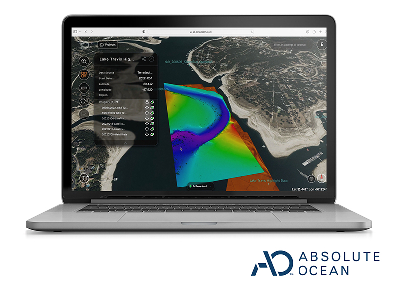
Subsea data collected for stakeholders can be shared, visualized, and collaborated on in near real-time, empowering smarter decisions and ensuring sustainable growth in challenging marine environments.

As the offshore energy sector continues to navigate the greater energy transition, there is more pressure to optimize resources and minimize costs while keeping data secure. 

The software operates in the cloud and can ingest diverse types of data, including bathymetric surveys, sonar scans, and video footage. 

By centralizing and simplifying subsea data access for teams, the secure platform offers visibility into the critical information they need to drive success.

Key Benefits of the Absolute Ocean Platform

Enhanced Decision-Making
Absolute Ocean centralizes seabed mapping, asset tracking, and environmental data in one secure platform. This enables leaders to make informed decisions swiftly and with precision.

Cross-Team Collaboration
Absolute Ocean’s cloud architecture promotes seamless collaboration between offshore and onshore teams. Data processing personnel can work anywhere in the world and concurrently to data collection to accelerate workflows. 

With a shared, up-to-date data set, stakeholders maintain alignment, greatly reducing timelines and improving the quality of decision-making across teams.

Risk & Environmental Management
The platform can visualize terrain data collected over time allowing management to anticipate and respond to environmental conditions, track changes, detect tampering and safeguard both assets and the marine ecosystem.

Joe Wolfel, CEO of Terradepth, commented, “Critical ocean data has historically taken days to months to get to decision makers. Now, using the Absolute Ocean platform our users are able to share and access visualized data within 24 hours. 

“Current systems can take weeks to realize actionable data. Our offshore partners in petroleum and wind are enabled to access their data in near real-time from any location on our new platform. This leads to safer, more cost-effective, and more environmentally conscious operations.”

Posted by William Mackenzie Will is a Content Specialist at Ocean Science Technology. Joining in 2024 with a background in professional copywriting and creative content, Will brings expertise in oceanographic monitoring, aquaculture, and environmental analysis. He provides in-depth coverage of breakthroughs in marine research, subsea systems, and autonomous platforms, drawing on his specialist understanding of ocean technology to highlight innovations shaping the future of the marine industry. Connect

Latest Articles

Real-Time Vibration Analysis Embedded in SBG Systems IMU

SBG Systems’ IMU now features built-in vibration monitoring, delivering real-time analysis to enhance accuracy, detect resonance, and support design, testing, and structural monitoring

Nov 19, 2025
Kraken Robotics Forms Reseller Partnership to Expand Access to Subsea Sonar Technology

Kraken Robotics has appointed BlueZone Group as an authorized reseller of its SAS and KATFISH platform, offering high-resolution underwater imaging, bathymetric mapping, and rapid data collection for defense and commercial surveys in Australia and New Zealand

Nov 19, 2025
Monitoring Marine Environments with Pro-Oceanus Dissolved Gas Sensors

Discover how Pro-Oceanus Systems’ advanced sensors help explore the oceans, measure dissolved gases, and uncover critical insights into marine and climate processes

Nov 18, 2025
Strategic Partnership to Deliver High-Resolution Deep-Sea Seafloor Intelligence & Insights

PlanBlue and Orpheus Ocean have collaborated to integrate advanced AI-driven imaging with autonomous underwater vehicles, enabling enhanced monitoring and analysis of critical deep-sea environments

Nov 17, 2025
FarSounder Integration Delivers Real-Time Seafloor & Obstacle Detection to SYNAPSIS Users

FarSounder has integrated its Argos 3D Forward Looking Sonar with Anschütz’s SYNAPSIS navigation platform, bringing real-time subsurface insights directly into the (W)ECDIS NX interface

Nov 17, 2025
Underwater Optical Communication Showcases 5.2 Gbps Transmission for Marine Applications

Kyocera has demonstrated a high-speed Underwater Wireless Optical Communication (UWOC) technology capable of transmitting data at 5.2 Gbps, enabling real-time, large-volume data exchange for underwater vehicles and ocean exploration

Nov 14, 2025

Featured Content

FarSounder Integration Delivers Real-Time Seafloor & Obstacle Detection to SYNAPSIS Users

FarSounder has integrated its Argos 3D Forward Looking Sonar with Anschütz’s SYNAPSIS navigation platform, bringing real-time subsurface insights directly into the (W)ECDIS NX interface

Nov 17, 2025
Boxfish ROV Captures Marine Research Footage for Upcoming Premiere

Scientists from the University of Tasmania used a custom Boxfish ROV to survey Beagle Marine Park, capturing underwater footage premiering on YouTube this November

Nov 12, 2025
SubC Imaging Observatory Camera Systems Support Long-Term Ocean Observation

SubC Imaging’s Observatory Camera Systems capture detailed subsea imagery for cabled ocean observatories, enabling continuous observation and long-term marine environmental studies

Nov 11, 2025