Xeos by Satlink has provided GNSS receiver technology to upgrade Greenland’s geodetic monitoring network, which tracks how the land responds to ice mass loss. The initiative, focused on measuring long-term postglacial rebound, is managed by the Agency of Climate Data (KDS) with support from the Technical University of Denmark (DTU) and EarthScope Consortium.
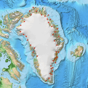
KDS assumed responsibility for the project in 2019, taking over the operation of more than 70 stations positioned around Greenland’s coastline. These stations use geodetic measurements to monitor vertical land movement caused by the reduction of ice sheet pressure, offering critical insights into ice dynamics and sea level change.
As part of the network upgrade, Xeos by Satlink contributed the Resolute Polar GNSS Receivers with Iridium satellite communications. The new receivers cut battery requirements by half, extending the service life of existing systems. At newly deployed sites in remote polar regions, the lower power consumption reduces the number of batteries needed, lowering overall logistical costs.
The receivers are also capable of transmitting more data with minimal power use and are equipped with micro-heaters that help maintain performance during extended periods of cold and darkness in the Arctic environment. These features support improved resilience while enabling higher data throughput.
The enhanced network continues to map Greenland’s vertical velocity field, strengthening scientific understanding of postglacial rebound and ice mass changes. This allows researchers to detect and model sudden variations in ice loss rates more effectively.
Beyond Greenland, EarthScope Consortium also provides operational support for Ohio State University’s geodetic monitoring program in Antarctica, where the new low-power Resolute Polar GNSS Receivers have likewise been deployed.