


Metocean Buoys
Discover cutting-edge solutions from leading global suppliers
AXYS Technologies explores how MetOcean buoys supply environmental data that offshore oil and gas operators use to support decisions throughout the lifecycle of a well.
Environmental data is required for offshore operations to meet regulatory obligations, inform the selection of drilling and production equipment, and maintain safe, effective operations. Continuous monitoring of parameters such as wave direction, current profiles, wind conditions, and salinity supports decision-making processes during planning and operations across all phases.
AXYS MetOcean Systems
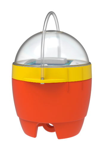
WatchKeeper™ MetOcean Buoy
Designed for coastal areas, lakes, reservoirs, and rivers, the WatchKeeper™ is a lightweight buoy intended for straightforward deployment and operation. It is configured to meet a range of monitoring requirements and allows for field servicing.
The durable and flexible WatchKeeper buoy, like all AXYS buoys, features the advanced TRIAXYS G3 Directional Wave Sensor. Its autonomous power system, consisting of solar panels and rechargeable batteries, ensures optimal performance in the harshest marine conditions.
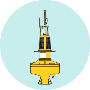
3 Metre™ MetOcean Buoy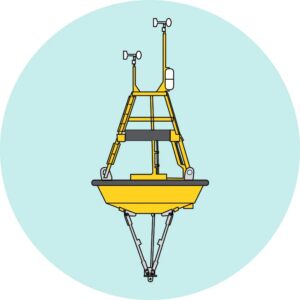
This aluminum buoy is suitable for offshore use and supports a wide range of sensors. The 3 Metre™ buoy is used to collect meteorological and oceanographic data under varying environmental conditions.
The rugged and highly capable 3 Metre aluminum buoy is an ideal offshore metocean platform for long-term data acquisition. This platform’s long term survivability and its substantial reserve capacity make it the ideal offshore metocean platform
Port Sentinel™ Automated Weather Station
The Port Sentinel™ is a self-contained, automated station for monitoring weather and water levels. It is typically installed in locations that support vessel traffic monitoring and includes sensors for wind, air temperature, humidity, pressure, current speed and direction, and tide levels.
The AXYS Port Sentinel system integrates with all IMO-approved AIS Class A transponders, supplementing their data with environmental information. This can be further enhanced by incorporating data from AXYS MetOcean buoys, offering a comprehensive view of meteorological, oceanographic, and water level conditions. The combined information can be broadcast in real time to various maritime stakeholders, including VTMS centers, pilots, port managers, ship operators, and bridge crews.
Monitored MetOcean Parameters
The following parameters are measured to support environmental monitoring in offshore oil and gas operations:
- Wind speed and direction
- Atmospheric pressure
- Air temperature
- Humidity
- Directional waves
- Current profiles
- Sea surface temperature
Project Lifecycle
MetOcean data is used throughout offshore project stages. During site selection and environmental assessment, it provides baseline time series and supports validation of historical data. In exploration, it contributes to nowcasting, model verification, and forecasting. During production, it is used for real-time monitoring, performance tracking, and analysis of structural stress and fatigue. It also remains relevant during the decommissioning phase for operational awareness and planning.


