Showcase your capabilities
If you design, build or supply LRIT Systems, create a profile to showcase your capabilities and connect with visitors who have an active requirement for your solutions.

Long-Range Identification and Tracking (LRIT) is used to report the identity, position, date, and time of applicable SOLAS vessels on international voyages. Unlike AIS, LRIT operates through controlled satellite communications, approved shipborne equipment, Application Service Providers, secure data centers, and the International LRIT Data Exchange.
This page showcases leading manufacturers of LRIT systems supporting maritime security, SAR coordination, flag and port state oversight, and long-range situational awareness.
Read the Technology Overview
Reliable Satellite Communication (SATCOM) Services & Equipment for Marine & Maritime Vessels & Platforms
If you design, build or supply LRIT Systems, create a profile to showcase your capabilities and connect with visitors who have an active requirement for your solutions.

Long-Range Identification and Tracking (LRIT) is a regulated international framework designed for tracking applicable Safety of Life at Sea (SOLAS) vessels on international voyages. Established under the International Maritime Organization (IMO) umbrella, LRIT systems enhance maritime security, search and rescue (SAR) capabilities, and marine environmental protection by operating independently of public vessel-tracking feeds or commercial fleet-management software.
Unlike the Automatic Identification System (AIS), which operates as an open ship-to-ship and ship-to-shore VHF broadcast, LRIT maritime tracking is a structured, closed reporting mechanism. Position reports containing ship identity, latitude and longitude, and the associated date and time are automatically transmitted from approved shipborne hardware through specialized communications networks and Application Service Providers (ASPs) directly to authorized governments and search-and-rescue agencies based on strict legal entitlements.

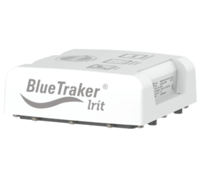
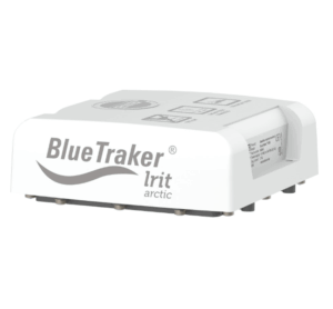
BlueTraker® LRIT Arctic Transponder from Iridium Communications
Conventional AIS relies on line-of-sight VHF radio propagation that limits its shore-based range to approximately 20 to 30 nautical miles. LRIT ship tracking bypasses these physical limitations by using approved satellite communications links and secure shoreside data infrastructure to ensure stable vessel reporting over transoceanic distances, giving authorized coastal, port, and flag states visibility over applicable Safety of Life at Sea (SOLAS) class vessels operating far beyond coastal AIS coverage.
The framework of LRIT is strictly aligned with the sovereign rights of maritime governments, categorizing data access by Flag, Port, and Coastal State roles. Telemetry is routed exclusively to entitled Contracting Governments and SAR services via secure data centers coordinated by the International LRIT Data Exchange, providing maritime administrations with a verified data stream that carries official authority and represents a strict compliance mandate for vessel operators.
When coordinating deep-ocean emergency responses, SAR authorities require validated information regarding the last known positions of vessels in distress and nearby ships available to assist. LRIT directly supports these operations by giving recognized SAR services controlled access to relevant vessel position information, helping narrow the initial search area and establish a resilient historical track that minimizes spatial uncertainty during remote ocean incidents.
The IMO mandates that LRIT on ships supports maritime security, safety of navigation, and marine environmental protection, making the systems highly valuable during pollution responses and casualty management within sensitive ecological zones. Environmental protection agencies can fuse controlled LRIT position reports with satellite synthetic aperture radar imagery and oil-spill trajectory modeling to confirm which regulated ships were present within a specific geography at a specific time.
As offshore wind farms, deep-sea cable deployments, and polar research expeditions push further away from the coast, the need for robust, long-range situational awareness increases. An LRIT system on ships enhances this operating picture by validating the positions of applicable SOLAS vessels operating near these assets, proving highly effective when offshore commercial projects or scientific research campaigns interface directly with state safety protocols and exclusive economic zone (EEZ) enforcement.
The LRIT network is not a standalone piece of shipboard hardware, but a highly integrated, end-to-end technical architecture consisting of specialized hardware and secure data routing layers.
BlueTraker® LRIT Tracking Transponder from Iridium Communications
The main difference between AIS and LRIT is that AIS is a decentralized, unencrypted VHF broadcast system used for ship-to-ship and ship-to-shore situational awareness, including collision avoidance. LRIT is not broadcast to nearby ships and uses controlled satellite communications and secure data routing through authorized LRIT data centers, providing a controlled, long-range statutory tracking layer that remains intact regardless of local VHF radio network limits or coastal congestion.
Satellite AIS (S-AIS) captures VHF radio signals from orbit to provide wide ocean coverage, but it remains vulnerable to packet corruption in high-density shipping lanes and manual data tampering by the crew. LRIT operates on a closed, dedicated reporting architecture governed by strict SOLAS performance standards, transmitting less frequently than S-AIS but delivering controlled position reports through a statutory international framework.
Vessel Monitoring Systems (VMS) assist fisheries management by providing enforcement agencies with periodic position updates from commercial fishing fleets to monitor quota compliance. The primary distinction lies in target fleets and governance because LRIT applies to passenger ships, cargo ships of 300 gross tonnage and above, and mobile drilling units engaged on international voyages, while VMS targets fishing vessels under local licensing frameworks.
Commercial platforms optimize logistics, weather routing, and fleet efficiency for shipowners using hybrid cloud dashboards and onboard IoT sensors. LRIT is entirely separate from these commercial optimization efforts, featuring no consumer-facing interfaces and no integration options for public logistics portals because it exists strictly within the regulated framework of global maritime safety and security.
Maintaining global maritime security and compliance requires continuous, structured coordination between shipboard engineering teams, satellite service providers, and national flag administrations.
A large percentage of operational non-compliance failures stem from administrative errors, such as outdated registry data or incomplete conformance tests, rather than physical hardware breakdowns during transit. Technical operations teams must ensure that LRIT documentation is integrated directly into standard change-management protocols during vessel acquisitions, satcom refits, or flag transfers.
The broader maritime domain awareness landscape is shifting rapidly from isolated data tracking streams toward highly integrated, automated sensing models.
As Autonomous Surface Vehicles (ASVs) and multi-sensor space platforms expand, the data ecosystem will rely on blending these emerging tracking technologies with the verified historical certainty of established systems. Fusing these layers ensures that remote operators maintain an accurate, controlled operational picture across open oceanic environments.
 Searching Companies & Products

 Subscribe to the Weekly eBrief
The latest engineering and technical developments straight to your inbox - join thousands of engineers who receive it.
Subscribe to the Weekly eBrief
The latest engineering and technical developments straight to your inbox - join thousands of engineers who receive it.