
Underwater Communication
Discover cutting-edge solutions from 5 leading global suppliers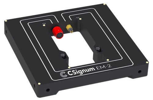
Underwater and underground data networking company CSignum has launched the EM-2 wireless platform, for IoT sensor data and control from above the surface to below.
The EM-2 interfaces to many frequently used underwater sensors to wirelessly communicate data from under the water to above the surface or directly on land.
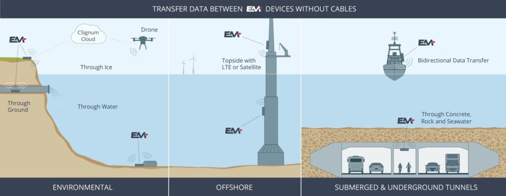
EM-2 represents a breakthrough in wireless communication technology employing electromagnetic fields to pass data through water, ice, concrete, and rock to overcome the limitations of traditional wireless technologies.
By harnessing electromagnetic field signaling (EMFS), data can be transmitted from below the water’s surface or underground to above-surface devices with impressive reliability.
EM-2 is a vital asset for the reliable transmission and retrieval of sensor data essential to monitor and protect resources and critical infrastructure across a variety of key sectors including:
Maritime Security & Defense
EM-2 offers a robust solution for enhancing maritime security by providing real-time data transmission from below the water’s surface to above-surface devices. This enables continuous monitoring of critical infrastructure such as ports and offshore structures, ensuring early detection and response to security threats.
Water Quality Monitoring
EM-2 revolutionizes water quality monitoring by facilitating wireless communication across the air-water boundary in both fresh and saltwater scenarios. It ensures reliable transmission of data from underwater sensors to above-surface devices, enabling timely assessment and management of environmental conditions in inland and coastal waterways, around offshore structures and aquaculture installations.
Offshore Wind & Energy Applications
EM-2 presents a game-changing solution for offshore energy applications by enabling seamless communication between subsea infrastructure and topside facilities. This enhances operational efficiency and safety in offshore energy operations, including wind farms and oil and gas platforms as well as inshore hydropower facilities.
Underground Applications
EM-2 extends its capabilities to underground applications, providing reliable data transmission through various layers, including buried structures. This makes it invaluable for monitoring and controlling underground infrastructure such as tunnels, storm drains, and underground utilities.
With bidirectional data transfers of up to 200 meters, EM-2 ensures successful deployment in both saltwater and freshwater environments. Its unique electromagnetic field-based communication method enables effective data transmission through mixed media scenarios.
Benefits of the EM-2 include:
- Resilience: Unaffected by biofouling, turbidity, or environmental noise, ensuring consistent performance.
- Flexibility: Easily integrated with various sensor packs and compatible with industry-standard data interfaces.
- Environmental Compatibility: No adverse effects on aquatic life, making it ideal for sustainable monitoring solutions.
- Diverse Environments: Operates through water, ice, rock and soil.
The versatility of the product lends itself to diverse applications including Internet of Underwater Things, ship monitoring, offshore structural monitoring, inland and coastal environmental monitoring, underground data monitoring, and defense and security operations.
Monitoring and assessing ecological health are essential components in combating and mitigating problems in critical inland and coastal waterways. Remote sensing observations utilizing EM-2 provides rapid, accurate data to assess and act on ecosystem changes.
Traditional methods of underwater communication face numerous challenges, from cable entanglement and unreliable communications to signal degradation. EM-2 offers a reliable, cable-less alternative, providing flexibility in deployment and superior performance across various environmental conditions.
Jonathan Reeves, CEO at CSignum, said; “EM-2 represents a quantum leap in underwater and underground communications technology. With its ability to transcend the barriers of traditional methods, EM-2 empowers industries to explore, monitor, and protect our waterways and subsea environments with unprecedented efficiency and reliability.”
Find suppliers & developers of Underwater Communications Technology >>