Satellite Buoys Find New Purpose Beyond Tuna Fishing

Marine Instruments' Blue Recovery Programme repurposes satellite buoys from tuna fishing to support ocean research, sustainability efforts, and circular economy practices worldwide By Joe Macey / 12 Jun 2025

Connect with Leading Marine Technology Innovators

Discover cutting-edge solutions from leading global suppliers
SUPPLIER SPOTLIGHT
Satellite Buoys Find New Purpose Beyond Tuna Fishing
Follow OS&T

Marine Instruments has introduced the Blue Recovery Programme, a global effort aimed at redefining marine waste management by recovering, recycling, and repurposing satellite buoys used in tropical tuna fishing.

This initiative reflects a growing commitment within the fishing sector to sustainability, turning oceanborne electronics into assets for science, conservation, and coastal communities rather than discarded waste.

Jorge Perez-Bouzada, Director of Sustainable Fishing at Marine Instruments, said, “With the Blue Recovery Programme, we take a step forward in our commitment to more sustainable fishing, where technology not only enhances fishing efficiency but also actively protects marine ecosystems.”

Satellite buoys.

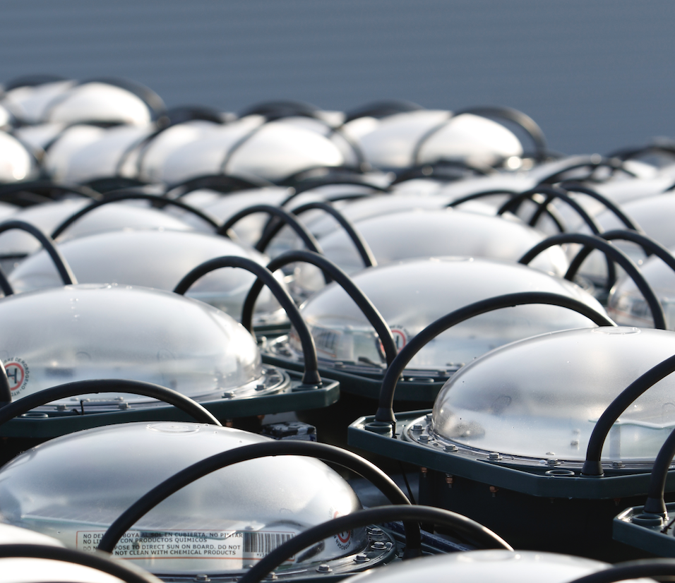
By applying a circular economy model, the programme extends the lifespan of advanced electronic devices that would otherwise contribute to marine pollution. Instead of being abandoned at sea or disposed of after use, recovered satellite buoys are evaluated, refurbished, and reintroduced into service with new, environmentally beneficial purposes. The Blue Recovery Programme is the product of a broad international collaboration between Marine Instruments and prominent organizations in the tuna fishing sector, with support from sustainability-focused associations and leading industry players.

Repurposed buoys are finding valuable second lives in a variety of applications, from tracking marine debris and monitoring coastal fishery resources to supporting Fishery Improvement Projects and studying ocean currents. They are also being used in the monitoring of whales and sea turtles, enhancing the work of environmental organizations, local communities, and marine research centers worldwide. In doing so, the initiative not only aids commercial fishing operations but also contributes to scientific knowledge and environmental stewardship.

Beyond equipment recovery, the programme actively encourages responsible operational practices, provides sustainability guidance to industry stakeholders, and fosters opportunities for circular innovation in the marine technology space. The Blue Recovery Programme stands as a model for how the fishing industry can evolve through collaboration, technology, and a shared responsibility for the ocean.

Posted by Joe Macey Connect & Contact

Latest Articles

Partnership to Advance Sustainable Practices in Subsea Operations

Ashtead Technology is partnering with Hydrollica to introduce a new generation of seawater-powered subsea tooling, promoting sustainability in subsea operations

Jul 18, 2025
Profile Spotlight: ALSEAMAR’s SEAEXPLORER Gliders for Oceanographic Monitoring

ALSEAMAR is presenting its SEAEXPLORER glider range on OST, offering autonomous underwater vehicles for long-duration environmental and industrial data acquisition

Jul 17, 2025
Profile Spotlight: SCIO Technology’s Modular Battery Systems for Maritime Vessels & Infrastructure

SCIO Technology is showcasing its SCIO Brick® battery system on OST, delivering modular electric power solutions for maritime vessels and infrastructure applications

Jul 16, 2025
Real-Time Video Streaming Now Available on SubC Imaging Systems

SubC Imaging has expanded streaming capabilities to Rayfin cameras, DVR+ Overlay and its Blackbox, through a straightforward, unified and consistent process across subsea configurations

Jul 16, 2025
SBG Systems Demonstrates Enhanced Performance of New Ellipse INS Firmware

SBG Systems evaluates its New Ellipse INS firmware through testing in AHRS and GNSS-aided modes, highlighting improved accuracy in dynamic, magnetic, and GNSS-denied conditions

Jul 15, 2025
Building Accurate 3D Seafloor Maps Using GIS & Geodetic Software

Researchers in Australia used Blue Marble Geographics’ Global Mapper® and Geographic Calculator® to convert raw bathymetric data into seamless 3D models for seabed mapping

Jul 15, 2025

Featured Content

Real-Time Video Streaming Now Available on SubC Imaging Systems

SubC Imaging has expanded streaming capabilities to Rayfin cameras, DVR+ Overlay and its Blackbox, through a straightforward, unified and consistent process across subsea configurations

Jul 16, 2025
Deep Trekker ROVs Streamline Offshore Inspections for Maritime Services Firm

Ynamly Yol Hyzmaty has adopted Deep Trekker’s ROV technology to enhance underwater inspection and non-destructive testing, reducing diver use and improving operational turnaround

Jul 14, 2025
New Unmanned Surface Vessel Outfitted with Voyager AI Survey System

Robosys Automation’s Voyager AI Survey has been integrated onboard Uncrewed Survey Solutions’ USS Accession, enhancing the vessel with advanced autonomous navigation and control capabilities

Jul 09, 2025