NOAA, RTSys & Arctic Rays Partner for Underwater Research Vehicle

The NemoSens SwordFish will gather baseline seafloor data, tracking changes to these ecosystems over time, set to play a vital role in supporting a vibrant blue economy By Abi Wylie / 05 Dec 2023

Autonomous Underwater Vehicles

Discover cutting-edge solutions from 4 leading global suppliers
SUPPLIER SPOTLIGHT
NOAA, RTSys & Arctic Rays Partner for Underwater Research Vehicle
Follow OS&T

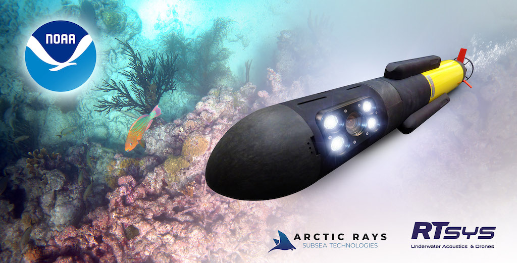
The NemoSens SwordFish autonomous underwater vehicle (AUV) is designed to revolutionize ocean exploration and research by enhancing NOAA’s efforts to understand the seabed. 

It was designed in a collaboration between NOAA’s National Centers for Coastal Ocean Science (NCCOS), AUV manufacturer RTsys, and subsea imaging technology manufacturer Arctic Rays.

NCCOS will use these vehicles to collect high-resolution digital images of the seabed as deep as 300 meters inside the United States Exclusive Economic Zone. 

These unique vehicles fill a technological gap and a growing need to provide sufficient images cost-effectively to characterize ecosystems and inform decisions about offshore energy development, sustainable fisheries and protecting special places in the ocean.

The state-of-the-art micro underwater vehicle will be equipped with SwordFish, an imaging payload developed by Arctic Rays. A fully integrated camera + lighting solution, SwordFish enables turnkey imaging acquisition for seafloor survey. 

The imaging payload features geo-referenced digital capture of 4K UHD video and still images with high-output dual-mode lighting and an onboard CPU and SSD storage.

This payload is integrated into the NemoSens micro AUV, developed by RTsys. The modular vehicle utilizes sustainable energy sources, minimizing its environmental footprint and allowing for extended mission durations.

The new NemoSens SwordFish is tailored to gather crucial baseline data about the seafloor, and track changes to these ecosystems over time. It will play a vital role in NOAA’s ongoing mission to protect and preserve our oceans and support a vibrant blue economy. 

This plan is part of the collaborators’ commitment to fostering a sustainable future for our planet. By joining forces, NCCOS, RTsysand Arctic Rays aim to better understand our oceans, mitigate climate change and protect marine life. 

Three primary units are scheduled for delivery to NOAA’s lab in Beaufort, North Carolina, early 2024. 

Pierre-Alexandre Caux, Business Director of RTsys, said; “We, in RTsys, are truly honored to have been chosen by NOAA’s National Centers for Coastal Ocean Science to elevate the research in marine biology, oceanography, and environmental science. 

“Upgrading NemoSens for studying marine life, mapping ocean floors, and collecting data on underwater ecosystems widens once again the capability of this unique and versatile micro AUV. The democratization of our combined expertise and shared technology will definitely lead to a more comprehensive understanding of our oceans and marine environments.” 

Posted by Abi Wylie Edited by Abigail Wylie, Editor and Copywriter experienced in digital media with a keen interest in ocean science technology. Connect & Contact

Latest Articles

Profile Spotlight: MetOcean Telematics & Maritime Satellite Communications

OST is helping MetOcean Telematics showcase its satellite communications and telemetry solutions, supporting marine industries like research, fisheries, and environmental monitoring

Feb 12, 2025
Understanding Deep Trekker’s BRIDGE Technology for Reliable ROV Control

Deep Trekker explains how its BRIDGE technology integrates hardware and software to enhance ROV operations, providing seamless communication between the vehicle, its controller, and third-party sensors

Feb 12, 2025
Actisense Enhances NMEA 2000 System Monitoring with New Features

Actisense has introduced new interface updates, including improved navigation, real-time NMEA data viewing, enhanced logging, network mapping, and simplified data routing for better system diagnostics and management

Feb 12, 2025
Iridium Certus® GMDSS Enhances Global Maritime Communications & Safety

Iridium Communications is launching the Iridium Certus® GMDSS, a comprehensive maritime safety and communication service that delivers global distress alerting, safety voice, and MSI capabilities through a single terminal

Feb 11, 2025
The Evolution of Maritime Autonomous Systems

Greenroom Robotics outlines the development of maritime autonomous systems, from basic autopilot functions to AI-driven platforms that significantly reduce human intervention

Feb 11, 2025
SubC Imaging Extends Maritime Reach with New Partnership

SubC Imaging’s new partnership with Dockstr, a provider of equipment solutions to the marine industries, is set to expand its reach to clients across the construction, renewables, marine, ocean science, and oil and gas sectors

Feb 10, 2025

Featured Content

Case Study: Trimble Applanix Technology Powers Hydrographic Surveys

In this case study, SEP Hydrographic Limited opted for Trimble Applanix technology to enhance its asset inspections, employing high-resolution 3D scanning for superior data quality above and below the waterline

Feb 10, 2025
Charles River to Develop MAGNETO Submarine Detection System for U.S. Navy

Charles River Analytics is set to develop its MAGNETO submarine detection system for the U.S. Navy, leveraging magnetic signals to to detect stealthier and quieter submarines

Feb 04, 2025
Teledyne Marine’s Slocum Gliders Enhance Conservation Efforts in the Roseway Basin

Researchers have deployed Teledyne Marine’s Slocum gliders in the Roseway Basin to detect and track marine mammals in near-real-time, enhancing conservation efforts through advanced acoustic monitoring technology

Feb 04, 2025