Discover World-Leading Technologies for Ocean Science
Discover cutting-edge solutions from leading global suppliers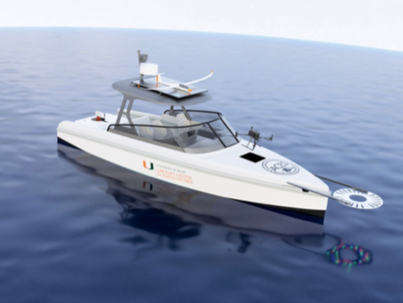
The University of Miami Rosenstiel School of Marine, Atmospheric, and Earth Science is set to receive the first flying electric research vessel in the United States, through a collaboration with Swedish company Candela.
This addition to the Rosenstiel School research fleet, will be part of the School’s Aircraft Center for Earth Studies (ACES), furthering its mission to conduct earth science studies utilizing sustainable, electric research platforms.
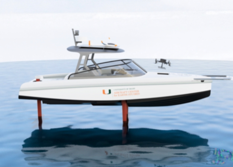
The ACES electric flying boat, based on Candela’s hydrofoil C-8, is built exclusively from carbon fiber and uses a set of retractable underwater wings with an advanced avionics and sensing system to lift the main vessel body above the water. The vessel has a cruise speed of 22 knots, with a maximum speed of 30 knots and can hydrofoil in wave heights up to 1.1 meters, beyond which it can still operate as a traditional planing vessel.
The flying boat will be used to support a number of new ACES grants from the National Aeronautics and Space Administration, National Geographic, and the National Oceanographic and Atmospheric Administration. The flying vessel will host ACES’ fleet of unpiloted aircraft, such as drones, for mapping of coral reefs and marine plastics using fluid lensing and MiDAR technologies, all while decarbonizing marine research.
“MiDAR will leverage the unique capabilities of the vessel for deeper water penetration as the flying boat does not produce a traditional bow wave while under way,” said Ved Chirayath, Director of ACES and the G. Unger Vetlessen Endowed Chair for Earth Studies. “The flying boat t-top and bow surface are used to launch ACES 3D printed solar and multirotor drones, which use the stable flight of the flying boat to reach take off airspeed and launch.”
The vessel is further equipped with radar to deconflict boat and airspace traffic. A custom solar array will be integrated onto the vessel, leveraging ACES’ previous experience building the TSERV, a tidal and solar powered research vessel. Between field sites, the vessel is towed by an electric vehicle, also charged using solar.
“ACES focuses on science-driven sensing and technology development to help better understand our changing planet. We are a growing multi-disciplinary team with a shared passion for studying and protecting life on Earth as well as aiding in the search for life elsewhere in the universe.” added Chirayath. “We develop novel instrumentation for ocean imaging, such as FluidCam and MiDAR, and artificial intelligence technologies, such as NeMO-Net, to map coral reefs and the seafloor. We test and validate our technologies through scientific field campaigns around the world, often in extreme environments that serve as analogs for planetary science and ocean worlds applications.”
In addition to the research missions, undergraduate students enrolled in Planetary Science, the Search for Life, & Oceans across the Solar System, a new course being offered at the University of Miami in Spring 2024, will be able to take a flight on the ACES flying boat through a field trip and teaching activities on the vessel.