Discover World-Leading Technologies for Ocean Science
Discover cutting-edge solutions from leading global suppliers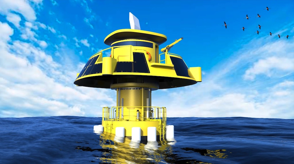
Three companies are combining their advanced detection systems and data collection technology to prevent birds and bats from colliding with the turbine blades of offshore wind farms.
Robin Radar’s MAX® bird and bat radar systems, Danish company DHI’s cameras, sensor integration and artificial intelligence (AI) species recognition solution MUSE, and Spanish company MIDO’s floating platform FLORA 1, a wave energy convertor generating all the power the systems needs.
The technologies will be deployed at Dutch offshore wind farm Ecowende, based in Rijswijk, and according to Ecowende the most ecological wind farm yet.
The floating platform with the bird and bat monitoring system aims to be operational at the end of 2024. From then on it will be collecting and providing data 24/7 and monitoring all birds across the wind farm. It will reportedly be the first floating system with such a radar in the world.
Wind farm operators have a tough line to tread. They must balance vital green energy production with the impact of turbines on surrounding wildlife. Especially birds.
Ecowende is pressing for a sustainable future for offshore wind; one that positively contributes to the North Sea’s ecology. Their planned wind farm will be the largest in the Dutch North Sea, providing a huge 3% of the current Dutch electricity demand with clean energy.
The Ecowende wind farm will be located about 53 kilometers off the Dutch coast, near IJmuiden. With an installed capacity of approximately 760 MW, Ecowende aims to have its wind farm fully operational and commissioned in 2026.
MIDO – A Partnership to Make Waves
As part of the project and for the first time ever, MAX® will deploy on a floating platform with MIDO. One of the four systems deployed will be installed on a custom-built power-generating floating platform, FLORA 1.
MIDO designs and develops specialized ocean energy technology. Based on proven engineering designs of wave energy converters, FLORA 1 will achieve renewable power generation for autonomous operation. Autonomy like this is fundamental for uninterrupted data collection.
From FLORA 1, the radar will detect, track and log the detailed data it collects on bird movements, behavioral and cyclical patterns, speed and height. All of this information is integral in forming part of Ecowende’s research to develop one of the largest wind parks in the North Sea.
This floating installation completes one of four radars to be installed on the site in total, with the other three located on turbines spread across the offshore wind farm to monitor birds and bats.
DHI – Seamless Camera Integration
Positioned on turbines, three MAX® radars will be coupled with cameras and an AI species recognition solution (MUSE) provided by DHI, technology leaders in camera operation.
MAX® can classify birds by size, and by integrating with DHI’s MUSE solution, even more information can be gathered automatically. This includes information on the actual bird species being observed.
The MUSE system provides frequent, high-quality observations without the logistical constraints and risks associated with human access to offshore turbines and substations.
Robin’s long-standing relationship with DHI will bring another level of detail and insight to Ecowende’s dedicated research. Having paired the MUSE system with MAX® on a prior project, the robust compatibility of the sensors is sure to further the quality of data collection.
MAX® – Built for Unparalleled Insight
With cutting-edge radar technologies, Robin empowers aviation, security and ecology heroes to set the pace for a better world. MAX® is built, from the start, for bird detection.
The system provides size, speed, height, location and flight path data for each bird or bat it detects. Operating 24/7 in all weather conditions, it can track thousands simultaneously, organising data into one informative and intuitive interface.
With the fastest rotation speed in the market, it gives track updates every second, allowing uniquely detailed 3D visualisation of bird flight paths, including exports to Google Earth.
Robin VP Wind and Environmental Practice, Sibylle Giraud, said; “Ecowende is the perfect example of the sheer passion for innovation you can find in this industry. There’s a real determination to keep finding new ways to protect wildlife while helping the green transition, and we’re very proud to be part of that.
“Like us, Ecowende will break ground and take risks to make essential technologies scalable and sustainable. We’re delighted to accompany them on this fantastic project, we’ll deploy no less than four flagship radars and our first-ever MAX® on a floating platform.”
For Ecowende and other future wind farms, the company envisions a flourishing ecosystem, with minimal impact on birds, bats and the underwater world.
Not only does their pilot project of ecological innovations have a positive ecological impact, but it also generates knowledge and increases understanding and support for offshore wind energy in the Netherlands and beyond.
The aim is to create a new ecological benchmark for the development and construction of wind farms at the North Sea, making it possible to build offshore wind farms in the future that have a “net positive impact” on nature. This is important because there are big ambitions for offshore wind, an acceleration is needed but in a way that contributes to nature above and below water.