1000m-Rated Saab Seaeye Falcon to Monitor Ocean around Canadian Coast

Ocean Dynamics has ordered a second, deeper-rated, Saab Seaeye Falcon for the inspection of instrumentation monitoring of the ocean around Canada’s northwest coast and First Nation coastal waters. By echoblue / 01 Apr 2023

Connect with Leading Marine Technology Innovators

Discover cutting-edge solutions from leading global suppliers
SUPPLIER SPOTLIGHT
Saab Seaeye Falcon-DR
Follow OS&T

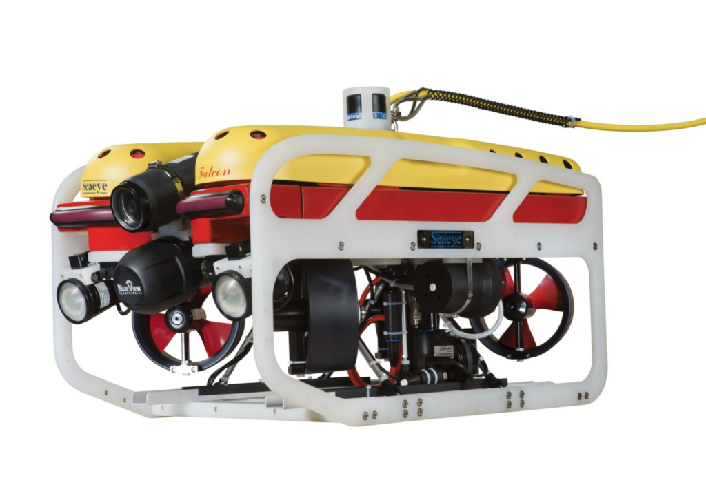
Marine Survey company, Ocean Dynamics, has purchased a 1000m-rated Saab Seaeye Falcon underwater electric robotic system, to inspect instrumentation monitoring the ocean around Canada’s northwest coast and First Nation coastal waters.

The company already owns a 300m-rated Seaeye Falcon, with the new 1000m-rated fiber-optic system selected because it can accommodate HD cameras and has the flexibility for integrating more advanced technologies.

The 1000m-rated Falcon can be fitted with a wide range of tools, sensors and cameras and remain steady in strong currents and turbulent waters

Ocean Dynamics’ President, Josh Chernov, says the Falcon has proved to be reliable and able to stay working for longer than other underwater vehicles — and has better quality video.

Ocean Dynamics supports the University of Victoria’s Ocean Networks Canada programme of 50 instrumentation platforms and six observatories, plugged into over 900 kilometres of fibre-optic cable on the seafloor. The network provides marine scientists and coastal communities internet access to data for ocean management, disaster mitigation, and environmental protection.

Along with an inspection role, the Falcon will be assisting in the removal and replacement of instrumentation platforms and cabling when needed.

The world’s most successful system of its class, the Falcon’s winning concept comes from packing five powerful thrusters and an intelligent distributed control system into a small, easily manhandled metre-sized vehicle that can adopt different tools and sensors for undertaking numerous intricate and demanding tasks whilst mastering strong cross currents.

Posted by echoblue Connect & Contact

Latest Articles

Advanced Subsea Positioning System Selected for Offshore Cable-Laying

Exail completes its first sale of the Gaps M3 USBL system, providing high-precision subsea positioning as part of a cable laying project for an Asian offshore construction group

Mar 27, 2025
MostaTech to Showcase Miniature Fiber Optic Gyroscopes at IEEE INERTIAL 2025

MostaTech will present its advanced fiber optic gyroscopes and inertial measurement units at IEEE INERTIAL 2025, highlighting precision, durability, and compact design for demanding applications

Mar 27, 2025
NMEA Selects Chief Engineer at Actisense as 0183 Committee Chair

Andy Campbell, Chief Engineer at Actisense, has been appointed NMEA 0183 Committee Chair, leading efforts to enhance the standard’s interoperability and future development

Mar 26, 2025
D-2 Enhances Manufacturing & Calibration Process for CTD Sensors

D-2 Inc. has improved its manufacturing and calibration processes, reducing CTD lead times and ensuring oceanographers receive equipment on schedule for critical research

Mar 26, 2025
ISS360 Imaging Sonar Enhances ROV Inspection Services

The ISS360 Imaging Sonar from Impact Subsea was chosen by Underwater Acoustics International (UAI) for its Seamor Chinook ROV, delivering a 360° field of view for underwater inspection

Mar 25, 2025
USVs & Multibeam Echosounders in Underwater Surveying

This case study from SatLabs Geosolutions outlines how the HydroBoat 1500 USV and multibeam echosounder were used to conduct a bathymetric survey in a narrow waterway

Mar 25, 2025

Featured Content

Elwave Provides CEDAR® Technology for Mine Countermeasures Program

Elwave is supplying its CEDAR® sensing technology to the European E=MCM program, enhancing mine countermeasure capabilities with advanced detection and classification solutions

Mar 24, 2025
Robosys Automation Unveils New Autonomous Trials Boat

Robosys Automation has unveiled its new autonomous trials boat, the ‘Pioneer’, designed to support the integration of its VOYAGER AI software for advanced maritime autonomy

Mar 18, 2025
Advancing Underwater Mapping with High-Resolution Echosounder Technology

CHC Navigation has introduced the HQ-400, a multi-beam echosounder utilized for bathymetric and hydrographic surveys which allows for reliable performance in underwater mapping and seafloor analysis

Mar 12, 2025