Discover World-Leading Technologies for Ocean Science
Discover cutting-edge solutions from leading global suppliers
Fugro, in collaboration with CGR, EOMAP (a Fugro company) and PlanBlue, is mapping Italy’s entire coastline to deliver a unified national dataset of seagrass meadows and seafloor morphology.
The large-scale survey forms a central element of Italy’s Marine Ecosystem Restoration (MER) project, led by ISPRA and funded through NextGenerationEU. The initiative supports the protection and recovery of marine habitats, focusing on Posidonia oceanica, a native seagrass species critical to Mediterranean biodiversity and carbon storage.
Building a National Baseline for Restoration
Seagrass meadows play a key role in capturing carbon, supporting marine life and stabilizing shorelines. Across the Mediterranean, Posidonia oceanica has declined by more than one-third over the past 50 years due to pollution, anchoring, coastal development and climate-related pressures. The MER project aims to reverse this trend by improving the quality and consistency of baseline data used for habitat protection and restoration.
Fragmented data has long constrained coastal management. Fugro and its partners are addressing this by producing a continuous, standardized dataset that integrates ecological and morphological information along Italy’s full coastal extent. The results provide a coherent national reference for restoration planning, environmental policy and long-term ecosystem monitoring.
The Value of an Integrated Dataset
This comprehensive mapping effort gives agencies, conservation organizations, infrastructure developers and insurers a common foundation to:
- Direct restoration and investment where ecological and economic benefits are highest.
- Design coastal infrastructure with accurate knowledge of seabed conditions and habitat sensitivities.
- Support funding cases using verified data on ecosystem services such as carbon storage, fisheries and shoreline protection.
- Measure progress using transparent baselines and repeatable performance metrics.
- Align decision-making among stakeholders using standardized, trusted data.
By consolidating geospatial information within a single reference framework, the project enhances confidence in restoration planning and accelerates environmental decision processes.
Multi-Technology Data Integration
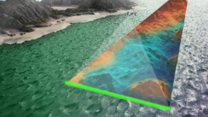
Illustration of the RAMMS technology acquiring bathymetry data
Fugro’s workflow combines satellite-derived bathymetry, Airborne Lidar Bathymetry (ALB), Multibeam Echo Sounders (MBES) and Autonomous Underwater Vehicle (AUV) validation surveys to create a seamless dataset from land to approximately 50 meters depth. Each dataset is precisely positioned using advanced GNSS and integrated into Italy’s national geodetic reference system. The resulting digital elevation models achieve centimeter-level precision, providing the spatial accuracy required for reliable analysis and ongoing monitoring.
Project coordination and data access are managed through Virgeo®, Fugro’s cloud-based geospatial platform. The system provides real-time visibility of survey data, vessel positions and project progress, improving collaboration between teams and supporting efficient operations.
Giordano Giorgi, Project Director at ISPRA, commented, “It’s not enough to use remote sensing, lidar, or autonomous systems on their own, you need to combine and integrate them into a dynamic, digital system. Without that integration, we won’t be able to turn diverse data into meaningful results. Our coastlines are complex, and mapping them requires a flexible, integrated approach that brings all these tools together.”
Transforming Data into Actionable Insights
Ensuring consistency between sensors is essential for accurate analysis. Fugro normalizes intensity values across MBES and ALB datasets to achieve uniformity, an important step for machine learning and automated seafloor classification. The processed data identifies Posidonia oceanica coverage, areas under stress and other seabed types such as rock and mobile sediment.
Autonomous underwater vehicles capture high-resolution seabed orthomosaics to validate classification results, providing detailed visual confirmation of seagrass condition. The dataset is segmented by geomorphological and ecological characteristics, supporting the creation of thematic habitat maps used in restoration planning and monitoring.
Quality assurance procedures maintain data accuracy across all sensors and processing stages. Multiple variables, including slope, aspect, backscatter and intensity, are integrated to produce reliable, high-resolution habitat models designed for repeat assessment.
Knowledge as the Basis for Restoration
The MER project demonstrates that existing technologies now enable marine restoration at national scale. By integrating remote sensing, autonomous systems and cloud-based data management, Fugro provides ISPRA and its partners with the geospatial insight needed to guide habitat protection and sustainable coastal development.
A clear understanding of Italy’s seafloor supports stronger environmental policy and a more resilient blue economy. High-quality data on seagrass distribution and health allows for targeted action to preserve biodiversity, mitigate climate impacts and sustain the ecosystems that underpin life along the Mediterranean coastline.
The activities are carried out under the framework of the NextGenerationEU investment projects – Mission 2: “Green Revolution and Ecological Transition,” Component 4: “Protection of Land and Water Resources,” Measure 3: “Safeguard air quality and biodiversity through the protection of green areas, soil, and marine areas.” Investment 3.5: “Restoration and Protection of Seabeds and Marine Habitats.”
Visit Fugro at Oceanology International 2026 (Oi26) on Stand E600. The world’s leading forum for ocean science, engineering and technology returns to Excel London from 10-12 March 2026, connecting more than 8,000 attendees and with every continent in the world represented. For more information or to register, visit the Oi26 website.